Category Archives: Thru-Hike Journal

The Pennsylvania Push

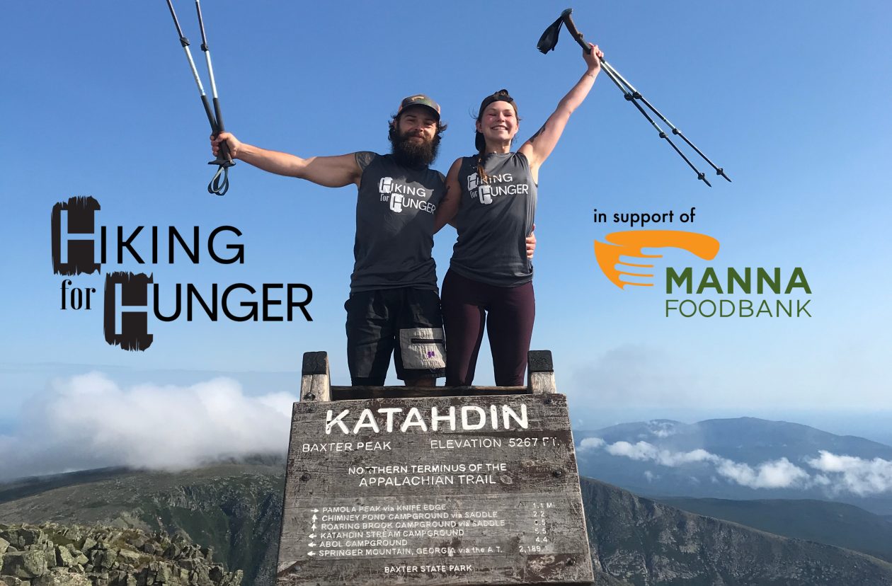
Days 86-96: Mason Dixon Line-Blue Mtn Lakes Rd., NJ

Before we dive into this next installment of the blog, a quick note from Hero and BAM!:

Hello wonderful readers! You may have noticed that we have fallen behind on the blog as of late. We wanted to take a moment to let y’all know what’s going on with that and reassure you that we will still be writing entries for the blog- they’ll just be published much later than they have been in the past.

One of the great things about the days lengthening as summer draws nearer is that we’re able to hike for longer hours during the day and cover more mileage. The downside to this is that we have less “tent time” in the evening, which is when we typically write up our notes for the day and do our journaling. We’ve also been hard at work trying to build up our social media presence, especially on Instagram. BAM! is also hard at work launching our YouTube page- stay tuned for deets! Feel free to look up Hiking for Hunger on YouTube and follow us there as we work to get some more timely videos up on our channel. Both of these things, the longer days of hiking and an extra focus on our online presence, have contributed to getting behind on the blog. We have also been taking time to enjoy the community out here on the trail, swapping stories with other hikers and building relationships this has also cut into our writing time but is something we both have been craving especially after this past year we have all experienced. 

Again, while we fully intend to continue to publish these journal entries chronicling our adventure, they will be delayed. We really appreciate y’all’s patience with us on this, and we truly can’t thank y’all enough for following along with us on this journey. Now, without further ado, we present to you “The Pennsylvania Push.”

PA Here we come!

Day 86 (Monday, May 10th, 2021)

AT Miles: 9.6

Mason Dixon Line > Chimney Rocks

1076.5 Miles Down, 1116.6 To Go

We woke up in our not so super hotel room and, remarkably, we both had slept really well. We finished our leftover Indian food for breakfast, packed up, and hit the road. We drove nearly the whole way back to Dulles then found a place to get a car wash. The car was covered in dirt and pollen, so we were worried they might take it out of our deposit if we returned it looking so dirty. After the car was squeaky clean, we got some smoothies and continued on to the car rental place. We pulled in to the parking lot to return the car. Someone came up to the driver’s side window and asked for our information. Then they said, “you’re all set just leave the keys on the dash.” We didn’t realize the process would be so quick. We hurried up and grabbed all of our stuff out of the car, trying to make sure we didn’t forget anything.

As soon as we grabbed our packs, we saw Hero’s dad (Tim) pull in – perfect timing! We threw our packs in the back and we were off. He drove us back to Waynesboro, PA where we decided to have lunch before getting back on the trail. We found a cool little spot resembling an old timey diner called Waynesbuger, and they happened to have Vegan Burgers! We were pretty excited and ordered those with some fries and a soda. We had a wonderful lunch with Tim and were so grateful that he drove us back to the trailhead and we’re just glad we had more time together.

After lunch, we drove back over to Pen-Mar Park and Tim hiked back to the Mason-Dixon line with us. We snapped a few photos together and marveled at the soggy teddy bear next to the sign – its fur looked like melting chocolate, but did not seem anywhere near as appetizing. We all stalled there and talked for a while more, not really wanting to leave each other again. Eventually, we said our “so long for nows” and started hiking down the trail. It was so hard to leave family and friends and come back to the trail after this extended break. We really miss our community of people. That being said, we were also glad to be back on trail and picking up where we left off. We have so much more beautiful trail ahead of us.

We didn’t actually start hiking until 1:30 PM, but that was ok with us- we were only planning to do about 10 miles anyways. We took our time and tried to take in being back on trail – it was beautiful! We pushed past some very well maintained shelters, some of the best we’ve seen, because we heard there were stealth campsites near Chimney Rocks, and we really wanted to catch the sunrise for our first morning back on trail. Right before we got to Chimney Rocks, I spotted a small patch of Pink Lady’s Slipper, the first ones we’d seen this year.

We pushed up to the side trail leading to the view and there are plenty of beautiful tent spots. Hero scouted out the nicest one and we put our packs down. We decided to run up the rocks and see what this view is like before getting set up – it was nice! We came back down and Hero built the tent while I made our signature first meal of the ration: vegan mac ‘n cheese. Another couple of hikers came in while we were cooking. They were so quiet we didn’t notice them at first, but then we waved and said “hi” and exchanged greetings- they seemed really nice, and the guy, we found out, helps maintain this section of trail. We were pretty tired after our long day traveling, so we crashed right after dinner.

View from Chimney Rocks

-BAM!

Sunrise at Chimney Rocks

Day 87 (Tuesday, May 11th, 2021)

AT Miles: 28.1

Chimney Rocks > Pine Grove Furnace State Park

1104.6 Miles Down, 1088.5 To Go

It’s 5:30 am. We have to readjust to waking up early, but today we are motivated by the promise of a beautiful sunrise at Chimney Rocks where we camped out for the night. We get ourselves out of the tent and up the rocks and indeed it is breathtaking! We have our pop tart breakfast up there with us and take it all in. Phase Two and Shebeast (the couple that camped near us last night) have also woken up for sunrise, so we chat with them for a bit as the sun pops up above the horizon line. It turns out that they are both avid section hikers and Phase Two is one of the trail maintainers for this section, so we talk about the trail and BAM! and I thank Phase Two for all he does to look after this section.

Soon after the sun has fully emerged over the horizon, we all head back to our respective camps to finish packing up. Both BAM! and I need to dig some cat holes, so it takes us a bit longer to get out of camp. Phase Two and Shebeast wave goodbye and say good luck to us as they head out and turn left to go southbound on the trail. We do a final sweep of camp, throw our packs on our backs, and take the right turn back out on the trail to head north.

It really is such a beautiful morning as we get going. We’re both still feeling fresh from our recent time off and excited to be back on the trail. It’s a good thing- we’ve got a lofty mileage goal for the day ahead of us. We’re going to try and make it to Pine Grove Furnace State Park if we can. We know it’ll be a push- 28.1 Miles if we can swing it- but we want to take advantage of some of the relatively flat and gradual Pennsylvania terrain while we have it.

We are walking along when we encounter a day hiker coming from the other direction. We all stop and chat for a bit and he lets on that he’s done some moderate section hiking over the years. His tone starts to shift and we notice that he’s beginning to give us some unsolicited advice regarding the Hundred Mile Wilderness up in Maine. He goes on like this, and at one point when he’s taking it upon himself to determine how fast we can make it through the Hundred Mile Wilderness, he looks me up and down. He points his trekking pole at me and says “If she’s up for it, you might be able to do it in four days. Maybe.” If she’s up for it. Not if we’re up for it- if she’s up for it. Me. He is, without a doubt, calling into question my ability based on the fact that I am a woman. He knows nothing else about me other than I look and sound like the mainstream notion of what constitutes a woman. I shake my head and give him a look while BAM! immediately jumps in and starts talking about how I am actually the faster and stronger hiker of the two of us- the guy cuts him off and continues to repeat his refrain. I know it’s kinda useless, but I’m grateful to BAM! for trying to bring some kind of awareness into the picture. Unfortunately, this guy doesn’t seem open to what BAM! is saying- he keeps interrupting him. I’m starting to move away from the guy, my body no longer facing towards him but facing northward on the trail- I’m ready to be out of this space, and I can tell BAM! is, too. I signal to him that it’s just plain time to go, and we start walking away. We get a good bit away before we start talking about what happened. We’re both upset but try to figure out how to respond when someone else further up the trail inevitably says something akin to what that guy said to me. But we’ve talked about this before, because it’s happened before, more times than I can count on both of my hands now. We brainstorm while also holding space for the fact that confrontation is not something that either of us are inclined towards. I’d like to say we figured out a solution, but you can’t know exactly how you’re going to react in the moment when these situations arise. Every time I think I will call out the sexism the next time it happens, I just would prefer to walk away and keep hiking. Time will tell, but for now I’m choosing to be kind to myself and not berate myself for just wanting to get away from the situation. I shift my focus to our goal of getting to Pine Grove Furnace State Park, where we hoped to partake in the Half Gallon Challenge.

We make good time getting to Caledonia State Park, where we fill up on water before moving on. While we are there, we call ahead to Pine Grove Furnace SP General Store to check in about ice cream. We had called them about a week prior during our time off to see if they’d be able to get some non-dairy ice cream in. It seemed at the time like it wouldn’t be a problem. Today, we called and heard a different story. Apparently, the guy we talked to last week had just gotten back from vacation and the freezer was empty- no ice cream whatsoever. When we called, he was in the middle of figuring out if he’d be getting ice cream in at all today. We expressed sympathy for the situation he was in and told him, too, that we were going to try and get to Pine Grove Furnace by 6/6:30 pm before he closed at 7 pm- if he happened to have vegan ice cream, we’d be excited to buy it. Regardless, we were excited to visit the store. He said okay and the call ended. We kept pushing on, still intent on making it all the way to Pine Grove Furnace despite the ice cream uncertainty.

We push the miles, the really nice terrain of Southern Pennsylvania working in our favor. We meet a pair of SOBOs (Bugs and Bambi) and a section hiker (Showtime) at the nicest shelter I’ve ever laid eyes on. Not only was it nice and clean, but it featured skylights, a bench swing, an immaculate spring, a sundial, and even more homey touches- so fancy! As we get close to PGF, we reach the AT Halfway Mark and soon thereafter pass 1100 Miles! We pass by another section hiker named Rambler and push on past the shelter where we initially thought we’d be staying before the call of ice cream had its hold on us.

HALFWAY!!!

We are dead on our feet by the time we see the first sign for PGF, but we’re still in good spirits- it’s only 5:45 pm, so we made it there faster than planned! We round the corner and know that the stone building just up ahead of us must be the Pine Grove General Store. My heart sinks and my jet-speed pace starts to falter- they are not open. We’re stunned- we had just talked to the guy who works here earlier that day. How are they not open? I approach the door and a small sign on the door indicates that current hours Mon-Fri are 11 am-5 pm. Crestfallen doesn’t even begin to cover it- we are beyond bummed. We unstrap our packs and throw them down next to a table while we decide what to do. Mercifully, there is a soda machine on the patio, so at least we can have a little something sugary and bad for us after our long day. I plop down in a chair and sip while I simmer and attempt to reel in my disappointment. I let go of my hopes of doing the Half Gallon Challenge here at PGF and focus my attention on the more pressing matter of where to stay the night. We’re trying to save some money, so we pass on the hostel in the creepy yet fascinating old mansion next door (we also missed the cutoff time for check-in, so that helps with the decision making process). The campground is not free, and it’s a fair walk down the road- ugh. We’d rather keep moving on and find camping further up the trail, but we would have to walk quite a ways to get off of the State Park property- no camping allowed anywhere but at the official campground. After some discussion, we decide on the PGF campground and start making our way down the road. The road walk hurts our already sore and achey feet, and as it takes longer than we initially thought it would, we start to wonder if we’ve made the right choice. But we get there, select a tent pad with a picnic table, and get to work on our camp chores.

While eating dinner, we face the next challenge head on: where are we going tomorrow? We look at both the AT guide and Guthooks and realize that there is a stretch of trail coming up where there is no camping allowed for about 18 miles, with the exception of a site around the town of Boiling Springs. Because of where we are tonight, we’d have to push waaaaaaay past a 30 mile day to make it to the other side of that 18 mile stretch- we know already that we are not going to feel up for that, and yet we need to make some bigger miles to keep on track with getting to the Delaware Water Gap in time for our second COVID shot. The only other option to get us the kind of mileage we’re hoping for is to stop in Carlisle. We look at the lodging options there and, having just stayed at the sketchiest Super 8 ever, we’re a bit tentative. We don’t want another experience like that, but we also can’t spend a lot on a room. We remember that one of our friends is from Carlisle- maybe she can tell us where we could stay that would be good but also reasonably priced. BAM! shoots her a text. Minutes later, a response: her parents would be happy to host us for the night. It’s unexpected and completely serendipitous, and we are immediately filled with gratitude and a huge sense of relief! Our friend sends BAM! her mom’s contact info and we start making plans.

Light starts to fade from the sky. I go to the bathroom (flush toilets and sinks, y’all!) a hundred yards from our campsite one last time before bed. I climb in the tent once I get back and start to bundle up- it’s already getting chilly. BAM! joins me after finishing up with getting tomorrow plans ironed out with our friend’s mom. We snuggle up and drift off to sleep, which comes easily now that the stress that once surrounded tomorrow has lifted.

-Hero

Appalachian Trail Museum- it was closed

Day 88 (Wednesday, May 12th, 2021)

AT Miles: 27.3

Pine Grove Furnace State Park > US 11 (Carlisle, PA)

1131.9 Miles Down, 1061.2 To Go

We left the State Park early, making one last stop at the bathrooms on our way out. We were still feeling a little bummed that we didn’t get to try the Half Gallon Challenge at the iconic spot, but we’re still planning to do it later. We were also a bit sad that we didn’t get a chance to check out the AT Museum- maybe next time.

We decided to make a stop at Green Mountain General Mercantile for an early lunch. We were craving snack foods, especially since we weren’t able to purchase anything from the Pine Grove Furnace store. We ordered some curly fries from the grill and got some chips and Stewart’s Orange Cream Soda. We went out to a picnic table and enjoyed our lunch in the sun. We tried not to linger since we had our friend’s parents picking us up in Carlisle tonight and we didn’t want to get in too late.

Nice little lunch stop!

We pushed through what we dubbed the “mini coaster” since it was a series of short climbs and descents. On the top of some of those climbs, there were large rocks that we had to navigate through like a maze. The white blazes literally took us around, up, and through the large boulders on a seemingly pointless route. In our guide, this section is labeled “The Rock Maze,” and there were two of them in this section. I guess the trail maintainers thought we needed an extra challenge! We met a nice couple at the Old Center Point of the trail. We chatted with them a while and listened to some of their stories from the trail. They were really nice and they told us their trail names: Cigar Lady and Old Tools. We said farewell to them and continued down to the pastures.

The next 15 miles consisted of flat fields and towns in what is known as the Cumberland Valley. We got to the first section of pastures and were super conscious about ticks – we checked nearly everytime we got to a clearing or a road crossing. Several of our friends who passed through this area before us said they found ticks after hiking through these fields. We went through the picturesque town of Boiling Springs, PA. We saw the children’s lake with all the ducks waddling about. We found the ATC Regional Headquarters there, and at the back of the building there was a spigot where we filled our water. It would have been a nice spot to hang out and have a snack or something, but we had to keep pushing because we had a warm bed and wonderful people waiting for us in Carlisle.

We went through lots more fields and crossed over many more roads and did several more tick checks. We finally arrived at the road where we planned to meet Ev and David. We walked over to the Quality Inn and arrived a couple minutes early- David wasn’t there yet. We took off our packs and sat down on a median in the parking lot- our feet were done at this point. Minutes later, David pulled up and greeted us then helped us get our packs in the back of the truck and we hopped in. We were so grateful that they offered to let us stay in their home tonight.

We chatted with David on the ride back, and he is so friendly and makes us feel right at home. When we get to their house, I opened the car door and David says, “you’re about to be attacked”. As soon as I angel myself out the door, an energetic golden retriever is in my lap wiggling excitedly and trying to lick my face. He is so adorable – I love every moment of it. It lasts only a moment because then Hero opens her door and he rushes over to see her. His name is Crosby and he is a two year old bundle of energy and a lover.

Crosby checking out the hiker smells

Ev comes out to greet us and so does her granddaughter. We grab our packs out of the back and Ev shows us to our room. The house is beautiful! She lets us know that dinner will be ready soon but to take our time and get settled in. We both start with much needed showers and get our stuff organized then head downstairs. We can smell dinner as we come down and it smells delicious. Ev has made sweet potato and black bean tacos with a guacamole sauce. We sit down and Ev offers us a glass of wine. Hero and I look at each other and say, “sure! why not”. David pours us a glass and we take a sip, it’s nice. Everyone sits down and we dig in. The tacos are delicious – Hero and I both have at least three each. It was so sweet that they made a completely vegan meal for us. We talked throughout dinner and really enjoyed the conversation and the company. After dinner, Hero and I went upstairs to work on a few Hiking for Hunger things. When we came back down, Ev and David were watching Mrs. Doubtfire in the living room – one of my favorite movies! We sat down and joined them. Ev offered us sodas and we both had a ginger ale. She also tried to find us ice cream or sherbert that we could eat in their freezer, but no luck. We told her we didn’t need anything else, we were already blown away by their generosity and the way they made us feel so welcome. After a little more Mrs. Doubtfire, our eyes were at half mast and we knew we needed to head to bed. We said thanks again and goodnight, then headed up to our room.

-BAM!

A wonderful breakfast with our Amazing hosts!

Day 89 (Thursday, May 13th, 2021)

AT Miles: 22.9

US 11 (Carlisle, PA) > Clark’s Ferry Shelter

1153.8 Miles Down, 1039.3 To Go

The faintest of light is just starting to creep into the world. It’s just visible between the yellow drapes that sway ever so slightly in the wind that gently whispers through the open windows. This is our cue to start waking up and get packed up, as much as we’d love to sleep in and enjoy being snuggly in this cozy bed. We do so and then venture downstairs for breakfast. Ev is down there- she’s laid out a whole assortment of breakfast options! It’s not often that we get to have cereal these days, so we take advantage of the opportunity to have that with some almond milk. There are bagels, too, and homemade jam- so heavenly! We enjoy this delicious treat and chat with Ev as we fill our bellies. David joins at one point, too, and Crosby the dog hovers nearby. It’s a great start to the day, and I think both BAM! and I could easily just stay here if that were possible, but we know we’ve got to get back on the trail and keep moving. We do get out a little later than we were planning because we are so enjoying hanging out with Ev and David- we’re so grateful for them and can’t get over how gracious they have been!

Eventually, it’s time to say goodbye to Ev and Crosby. We thank Ev profusely and climb in the truck with David, waving energetically as we pull out of the driveway and back onto the road. We talk with David during the ride back to the trail- like us, he’s done some hiking in Colorado, so that was a point of connection. In no time, we’re back at US 11- David throws on his four ways and pulls to the side of the road so we can safely get our packs out of the bed of the truck. We thank him again and he wishes us good luck on the rest of our journey. Then we turn and face the trail once more.

We spend the next stretch hiking the rest of the field section that doesn’t allow camping, worrying incessantly about ticks and checking ourselves frequently when we go through super tall grass. Despite the tick worry, it’s a pretty section and we are in great spirits as we plug along. We cross a lot of roads, which apparently is the name of the game here in Pennsylvania. We run into a group of Amish women enjoying a backpacking trip- we exchange big smiles and hellos as we pass each other. After some time, we arrive at Hawk Rock, a spot with a view overlooking the town of Duncannon below. We snap a few pictures but move on pretty quickly- we are eager to get into town for food and a quick resupply.

The descent into Duncannon is rocky and steep in sections, but we’re able to navigate it safely and get down alright. Soon, we’re walking on pavement and entering the town proper. Our first stop once we’re in town is Kind of Outdoorsy, the local outfitter which also now boasts a hiker hostel. We’ll stop in here to see what we can get for our small resupply, and anything we can’t find we’ll look for at the Quick Mart around the block. We’re able to find some Knorr Rice Sides and packets of oatmeal- that’ll cover breakfasts and dinners. We don’t really find any good options for vegan friendly snacks, so we resolve to check out the Quick Mart for those. We take our items to the counter and it turns out the lady who works there has been following us on Instagram! Wow! How cool is that?!?! She’s super nice and praises us for what we’re doing and we thank her so much for following along. We’re giddy as we sign their logbook and make our way out of the store.

We exit the store, but I sit on one of the benches outside with our packs while BAM! runs over to the Quick Mart to finish up our resupply. I start searching for food options for us- we’re in town, so we figure we might as well grab an early dinner, which will save us some time later on when we get to camp by not having to cook. There aren’t a whole lot of options for us, but I find out that we can go to the pizza joint across the way and we should be able to get pasta marinara without any cheese or meat- it’ll do! BAM! returns from the Quick Mart with snacks for the trail as well as some yummy things to eat while we’re still in town. As we are getting our food packed up so we can head over to the pizza place, a familiar voice calls our names. We turn to look back towards the front entrance to Kind of Outdoorsy and there’s Lost Bells! It’s great to see her again and catch up on all that she’s experienced since the last time we saw her. After a few minutes of swapping trail stories, we say farewell to her and move on.

We walk across the street to the pizza place. BAM! isn’t convinced that the pasta alone will be enough, so we order a cheese-less pizza, too. We scarf it all down and savor our last bit of town time before moving on from Duncannon. While walking the town portion of the trail, we discover that the residents are super friendly! Several people smile, wave, and wish us luck on our journey, including a guy who tells us to look out for his house as we walk down the street: “It’s the one with the 8 ft bear in the yard!” Sure enough, we spot it a little ways further, haha! Soon we are crossing over the mighty Susquehanna River. We get to look back at the mountains we came down earlier today and it is both a beautiful and deeply satisfying moment despite our being on a noisy bridge with lots of cars and trucks flying by. After getting across the bridge and crossing a few railroad tracks, we are back in the woods, climbing up Peters Mountain. It’s a steepish climb, but we’re still feeling spry, probably because we took such a nice long break in Duncannon. As we are doing the last few miles to shelter, we start to experience more rockiness- is this the start of how Rocksylvania got its name? Time will tell.

We make it to the shelter and discover that the only other person there is camping, so we spring for the empty shelter. Because we ate an early dinner in Duncannon, we spend the rest of the evening snacking, stretching, and writing. As light fades from the sky and the sounds of evening start to press in, we cozy on up in our double bag and drift off to sleep.

-Hero

Morning View of the Susquehanna

Day 90 (Friday, May 14th, 2021)

AT Miles: 25.3

Clark’s Ferry Shelter > Tent Site Near Rausch Creek

1179.1 Miles Down, 1014 To Go

We struggle to get ourselves out of bed this morning, hitting snooze several times and wishing we could just go back to sleep in our cozy cocoon. We had stayed up later than we intended, working on our writing and other H4H stuff, and then neither of us really slept all that well. Finally, we manage to pull ourselves together and get out of the sleeping bag. While we are eating breakfast and getting organized, the section hiker who tented a few hundred yards from the shelter last night joins us at the picnic table. He introduces himself as Peaceful Turtle, and we all share pleasant conversation over breakfast. We finish up our food, pack up, say farewell and good luck to Peaceful Turtle, and link back up with the trail.

The day starts with a ridge walk. There are little ups and downs, but for the most part this section is pretty level. Every so often we encounter rockier sections that make us wonder if we’re starting to really truly enter the domain of Rocksylvania, as we’d been told it was the northern section of trail in PA that is notorious for its rockiness. But so far it doesn’t seem too crazy. As we hike the ridge, we enjoy beautiful views of the Susquehanna River, and the weather is really quite mild. Despite the good conditions and pretty views every so often, we’re in a bit of a funk this morning, probably because we didn’t sleep all that well. We keep on, though, as we try our hardest to push miles and make our goal for the day.

Both of us start to realize after an hour or so on the trail that we’re going to need to brown blaze into Peter’s Mountain Shelter in a few miles. We get there and meet a thru hiker named Turtle Hawk. I seem to be more desperate for the bathroom than BAM! at this very moment, so I rush over to the privy. When I get back, Turtle Hawk and BAM! are talking about a game, something that sounds a lot to me like Dungeons and Dragons. It turns out that Turtle Hawk is working on creating a game akin to Dungeons and Dragons, but specifically for thru hikers. He asks us if we’d like to join and be characters in this game and we say yes, absolutely. BAM! is filling out his preferred “powers” and then I do, too. Other thru hikers have also filled in their “powers” in Turtle Hawk’s game. As we get ready to move on from the shelter, Turtle Hawk says that he’ll send us an update on the game and we say thank you and wish him luck on the rest of his thru hike. We really enjoy this stuff, the things that other hikers come up with to engage each other and create spontaneous and fun moments on the trail. Admittedly, this section of the trail can feel a lot like a grind, and we as well as other hikers are trying to find ways to keep our spirits high so we can keep going.

We continue hiking and eventually get to a spring a couple hundred yards off the trail near Clark’s Creek and stop there to fill up on water. We are both feeling tired, and BAM! is having trouble continuing on because of how exhausted he is. He asks me if we can take 20 minutes to power nap before continuing on. I worry about getting into camp late if we take too much more time, but I can also tell BAM! is really tired. Him advocating for a nap over pushing through is an indicator of just how tired he is- he’s usually one to just push through. I nod yes, let’s do it, and he sets an alarm, finds a flat spot, puts his butt pad down, and lays his head and shoulders on it, the rest of his body in the dirt. He slides his hat over his eyes, folds his hands over his stomach, and within 30 seconds I hear him snoring. Wow, he is seriously tired! I decide to lay down for the 20 minutes, too, and although I don’t quite enter a deep sleep like BAM!, I can feel a haziness and restfulness take over. In what feels like no time at all, the alarm is going off, and I’m jolted from that weird half-asleep, half-awake state that I had slipped into. I turn my head to the left and see BAM! stir and start to come to- he tells me that he had dreams during that short 20 minute power nap! He feels a bit better now, and we still have 11 miles to go, so we collect ourselves, make sure our water is all topped off, and get going.

Pretty soon after we’re back on trail, we throw in our earbuds and start listening to music- it helps us push the rest of our way to our goal camping spot for the night. Originally, we were thinking about staying at the Rausch Gap Shelter, but when we see that it’s a little ways off trail, we opt to get a bit further and camp at some tent sites just off the trail near the creek. The spot turns out to be perfect- it’s nice and open near the tenting area, but still has some tree coverage for privacy from the trail. There are remnants of the old stone buildings that were a part of a coal mining community that was located here but had to be abandoned when the operation wasn’t producing enough to be competitive.

After dinner, we crawl into the tent and look ahead to the next day- there’s a beaver dam just a few hundred yards further down the trail that we’ll be crossing first thing in the morning. What fun that will be! For now, we are so tired and just want to crash out and hopefully make up for some of the lost sleep from last night.

-Hero

Morning Fern Forest

Day 91 (Saturday, May 15th, 2021)

AT Miles: 27.5

Tent Site Near Rausch Creek > Tent Site Near Black Swatara Spring

1206.6 Miles Down, 986.6 To Go

After eating breakfast and packing up, we start the day by crossing the beaver dam a couple hundred yards from our campsite. Knowing that we’d be getting our feet wet for this one, we take off our hiking shoes and put on our camp shoes. We start to walk slowly and carefully across the dam, trying to stay on top of it as much as possible. There are a few spots where we have step into knee high water- it’s super mucky and quite cold! But not terrible, and honestly it’s just so neat to be crossing this incredible feat of beaver engineering. BAM! takes the opportunity to film a BAM! of the Day. I keep moving, slowly lifting my feet with each step so that I don’t lose my camp shoes in the muck. Eventually, I get to the other side of the dam and find a stump to sit on so I can wipe off my feet and put my hiking shoes back on. BAM! joins me shortly thereafter, and after our feet are cleaned off and back in our shoes, we start hiking again.

We’re both feeling sluggish this morning, and we try not to overwhelm ourselves by thinking about the 27.5 miles ahead of us. Instead, we enjoy the early morning hours in which the temperature is perfect and the sun isn’t bearing down on us ruthlessly. BAM! cracks me up at one point when he practically yells a cheerful “hello” to a couple of hunters who are trying to be stealthy. Not long after passing the hunters, we come to a road where a gentleman is offering some trail magic. He gives us each a vitamin water and some Larabars. We talk to him for a bit and find out the his name is BooRay. Really nice guy, and we so appreciate the trail magic he provides as well as information about the trail ahead!

We continue to meet nice people along the trail as we work our way through Swatara State Park. When folks hear that we’ve walked all the way from Georgia and are heading up to Maine, they express excitement and wish us good luck- it feels good and reaffirming every time we hear such positive feedback! We keep plugging along, passing under I-81 and working our way up some switchbacks up onto a ridge. The ridge walk feels endless. For as much as the flat terrain is kinder to our bodies, longer stretches can feel interminable. At some point while up on the ridge, we come to the William Penn Shelter and each take advantage of a much needed privy stop. From there, we press on, and when we finally come to the next road crossing we find TurtleHawk (the thru hiker we met the other day) and his friend set up with some trail magic. They have coolers full of treats and chairs set up so that thru hikers can sit down and relax while they take a break. It’s fun to see TurtleHawk out here, and we think it’s super awesome that he’s using his zero day to pay it forward and show other thru hikers some love. While we’re there, we meet another thru hiker named Teacher. He leaves the trail magic spot around the same time we do, so the three of us hike together for a couple of miles. Eventually, he branches off to check out a shelter a ways off the trail that supposedly has a shower. We continue on, but tell him that we’ll likely see him further up trail.

After a while, we reach the tree that marks the 1200th mile of our journey- woohoo! We snap a few quick photos and keep walking- we’ve still got a ways to go to make it to our campsite for the night. Not long after, a hiker ahead of us starts to come into view- he’s hiking fast, but we’re gaining on him. I catch glimpses of him from around BAM!, who is walking in front- there’s something familiar about the hiker just ahead of us. We catch up to him and it turns out to be Goldie! This is the first time we are seeing him since we crossed paths at the Nantahala Outdoor Center back in North Carolina! It’s awesome to see him again- we weren’t initially sure if our paths were going to cross again before reaching Maine, but here we all are! We all hike together to the next water source near the Hertline campsite. It’s fun chatting with Goldie, and it really helps pass the time. Before we know it, we’ve arrived at Hertline and we all get to work on water. Not long after we start filtering, Teacher shows up. He’s planning on staying here at Hertline for the night, but BAM! and I and Goldie are all trying to get a little further so that we’re set up to get into Port Clinton on the earlier side tomorrow. Goldie finishes filtering first and heads out- he might be heading to the campsite we’re looking at, but he might try to push further. At some point, the person staying in the tent that was already set up when we got here emerges- she goes by S8parks and we talk with her for the rest of the time that we are filtering. Once we’re all topped off, we say goodbye to Sparks and Teacher and press on.

1200 Miles!!!

It’s another 5 miles to our goal campsite and boy is it a trudge. We both throw on music to help us make it these last miles as our bodies start to tell us that they’re running low on gas. It’s a push, but we make it- we are not going any further, though. Goldie isn’t here- he must have decided to push on- but we meet a flip flop thru hiker named Arizona who is set up for the night in his hammock. He’s getting ready for bed when we show up, so it’s a quick “Hi, how are ya” before he’s crashing out. We try to be as quick and as quiet as possible while we get set up and make dinner. Soon enough, we’re heading to bed with the hopes of catching as many Z’s as possible before our early start in the morning- my mom is resupply us in Port Clinton and I can’t wait to see her!

-Hero

The train yard at Port Clinton

Day 92 (Sunday, May 16th, 2021)

AT Miles: 26.4

Tent Site Near Black Swatara Spring > Tent Site Near Panther Creek Spring

1233 Miles Down, 960.1 To Go

I woke up several times before the alarm went off, worrying for some reason I wouldn’t hear it or it wouldn’t go off. I would wake up, check the time on my phone, and then try to go back to sleep. The other thing waking me up was my aching feet. No matter what way I slept and what angle my feet were laying, they hurt. When 5am finally came, I was already awake and knew I wasn’t getting back to sleep. I still hit snooze for 5 minutes, and Hero and I cuddled a bit longer. Then the alarm went off again and I sat up and started getting packed.

I got out of the tent and took the first few steps of the day. It hurts to walk and I am limping around like I’m literally walking on eggshells. The more I walk, though, the more my feet seem to loosen up and hurt a little bit less. We were trying to be very quiet while packing up because Arizona was still sleeping. By the time we finished packing and ate breakfast he was awake. We said goodbye to Arizona and got on the trail.

Within the first few miles, we saw Goldie at the next campsite up trail. He had pushed a few more miles last night. We said good morning and had a quick chat, then said we hoped to see him again soon. We needed to make miles this morning because we were meeting Momma Grant in Port Clinton. As we were hiking, we met a group of four guys hiking and struck up a conversation. They asked some questions about our Thru-hike and the Fundraiser. One of the guys, trail name PIMA which stands for something I can’t say on the blog (Pain In My… you get the picture!), had section hiked nearly the whole trail. He gave us some advice and encouraged us to take our time and eat some berries in Maine. They were a nice crew. We said goodbye and pressed on.

We were running a little late at this point and the descent into Port Clinton was very steep with nothing even resembling a switchback. We tried to keep up the pace but our knees were screaming at us and my feet were starting to ache again. They seem to get a little better in the mornings as we start hiking, but as the day progresses the pain gets worse again. We walk down to the train tracks as Momma Grant pulls up. She parks and we run over to greet her. It was so good to see her and we were very grateful that she brought us a food resupply.

She tells us there is a Burger King down the street so she can just drive us there to get Impossible Whoppers for lunch. That sounds great to us so we throw our packs in the back and hop in. Cushioned seats feel so nice we could easily take a nap in the back seat. We went to a gas station first to use the bathroom and find sour patch kids, then to BK and we got Impossible Whoppers. We each got two whoppers and a side of fries. After scarfing those down, we swung by Walmart to grab a few things.

Momma Grant drove us back to the trail station and parked in the exact same parking spot that we had left from to make sure we didn’t miss any of the trail – HaHa! We packed up the resupply she brought us and said thanks, then came the challenging goodbye. We all hugged and cried a bit. We knew we would see her again soon, though which made it a bit easier. Goldie came by right before she left, and Momma Grant offered some stuff we weren’t taking. We also told him that it looked like someone was set up with trail magic right down the trail a bit.

We started hiking a couple minutes later. We walked past the van offering trail magic and saw Goldie and Arizona there enjoying some food. The trail angels offered us some and we said thanks but we’re full. We had just downed a lot of BK and what they were offering definitely wasn’t vegan friendly. We said thanks and told them we appreciate what they’re doing for hikers, then pushed through Port Clinton.

The rest of the day was a slog. We did another 13.2 miles after picking up the resupply. The day seemed to drag on and my feet were very sore. It felt like my arches were on fire and I had pain with every foot strike. I knew my shoes were near the end of their life, but this seemed like something more. Still, I thought that maybe my feet are just really bruised and beat up from all the pointy rocks. Either way, I was slowing down and we didn’t get into camp until much later than we had hoped. We still made it before sunset, but barely.

Hero started setting up the tent and I went to get water. As painful as my feet had been hiking, it was so much worse just standing still as I waited for our water bucket to fill up. Now my arches were screaming with pain and I had to lift one foot at a time and walk in place to try and relieve some of the pain. I sat down to cook and this helped relieve the sharpest pains and reduced it to a steady ache. I tried to get up as little as possible for the rest of the evening. After dinner, I took some Tylenol and hoped it would dull the pain enough for me to sleep a little better tonight.

– BAM!

Pennsylvania Farmlands

Day 93 (Monday, May 17th, 2021)

AT Miles: 26

Tent Site Near Panther Creek Spring > Tent Site North of George Outerbridge Shelter

1259.1 Miles Down, 934 To Go

It’s about 3:30 or 4:00 in the morning when noises outside of the tent wake me. For a few seconds that feel more like excruciatingly long minutes, I lay there just listening, still only half awake. My heart rate starts to tick up as my deliriousness lessens and I begin to register the sounds. My hand instinctively gravitates towards BAM!’s. I squeeze his hand and he squeezes back- the noise beyond our nylon walls have woken him up, too. We both lay still as the sounds of several somethings walking around draws closer to our tent. At some point, I can hear, very clearly, something sniffing just outside of my side of the tent. Hearing this stirs something in me, and I immediately yell “Hey!” very loudly. The sniffing stops and we hear the somethings that were surrounding the tent retreat- their movements fade away as they run further from our tent. When it has been quiet for a few moments, I let out a sigh of relief: “That got me, I was scared for a minute there,” I say to BAM!, turning to face him. He returns the sentiment, and we both begin to speculate as to what the somethings could have been. “Hunting dogs, possibly,” he says, “We’re on State Game Lands, and it sounded like those animals were wandering around a lot like domestic animals. Wild animals are more efficient with their movements- they don’t wander all about like that because they need to conserve energy.” It makes sense, but we’re still not 100% sure what exactly it was outside of the tent. That is until BAM! gets up to go pee about a half an hour later. He has his red light on and it catches a pair of glinting eyes no more than 20 feet away. It catches him by surprise, so he turns on his bright light so he can see exactly what it is he is having a staring contest with- it’s a doe, who apparently could care less about our presence as she continues to snack in our campsite. So, perhaps it was actually a herd of deer outside of our tent earlier? It seems unlikely now that it would have been hunting dogs, what with the doe that has stubbornly remained at our campsite. BAM! comes back to the tent and we try to get a little more rest before we have to wake up.

We wind up sleeping later than we should given the miles we are trying to do today, but our bodies need the rest badly. We’re still tired after being woken up by what we now think were a bunch of curious deer earlier this morning. It takes some effort, but we get ourselves to start packing up around 6 or 6:30. We eat breakfast, filter water, finishing packing up our packs, and roll out.

Not long after we get going, it hits me: I’ve gotta GOOOO! I hope that I can make it to Eckville Shelter a couple of miles away where there is supposed to be a flush toilet. I’ve gotta make it there, I tell myself. It gets to the point where I have to run ahead of BAM! I get to the road and am confused- is it down the road? I yell back to BAM! and he replies that “yes, you’ve gotta go down the road.” I start going that way (waddling that way, really), and after a while a house appears with a sign in front indicating that this is where the Eckville Shelter is located- interesting. BAM! and I look around in search of the bathroom- there are few different structures onsite that could be it. I find it and jump inside- I’m so glad I made it. BAM! has to go, too, so we trade places once I am done. There’s a spigot, so I fill up our water bottles while I wait. There’s a place to charge electronics, so we take advantage of that, too, though we don’t stay much longer. We see the caretaker, but only briefly. A man looking for the trailhead has parked his car in the caretakers driveway, so the caretaker is asking him to move his vehicle.

We leave Eckville, a little sad that we didn’t stay there last night (free access to a flush toilet, shower, and electrical outlets are a big deal to thru hikers, y’all), and start pushing miles. We’re pushing, the rocks are wreaking havoc on us, and we are hurting. This section of trail is literally taking us up over massive rock piles for no apparent good reason- the trail could have easily been routed around the piles of sharp, shoe destroying rocks. Around the point that we reach Allentown Gap Shelter, we’ve started discussing alternatives for how to proceed. These big mile days in the thick of Rocksylvania are really taking a toll, and we are running out of steam. We’re worried that if we keep doing what we’re doing that we might wind up getting injured. At the same time, we’re feeling like we need to get the miles done so that we can give ourselves time to recover from our second dose of Pfizer, which we plan on getting in a few days once we reach my moms house near Delaware Water Gap. As we brainstorm, we think of a way that we could do this that won’t run us completely into the ground. Once we have our game plan figured out, we call up my mom and see if she can help us pull off this adjusted plan (it includes picking us up a day early and helping us slackpack a few days). She’s totally down, and we are so relieved! We just need to get through the rest of today and tomorrow- she’ll pick us up in Wind Gap tomorrow afternoon. I get off of the phone, and though we still have a lot of ground to cover today, BAM! and I rejoice. We finish up with our snack break and press on.

We hit a lot of rocks. Rocks on rocks on rocks. To my surprise (and his), BAM! has to go dig a cathole in the middle of all of this- he encourages me to press on to the next marked water source and get a jumpstart on filtering. I do this, traversing over some of the super rocky spots along this section. Some spots are cool, like the Knife’s Edge, which makes me feel like I am climbing along the spine of a massive dinosaur. But for the most part, it’s a lot of that same Rocksylvania sharp, pointy rock stuff that’s been killing our feet. I’m excited when I hit a patch of less rocky trail and can walk with relative ease. I’m getting close to the road and parking lot area near Bake Oven Knob. Before I get to the road, I stumble upon a water cache! Woohoo! I don’t have to worry about filtering water- that’s a huge win in my book! Thank you trail angels! With this wonderful new development, I am able to take off my pack and chill for a second while I wait for BAM! to catch up. I chug some water and fill up my bottles and BAM!’s little bottle. About ten minutes go by and I see BAM! rounding the corner. “Take a look at this!” I say to him as he walks up. He sees the gallon jugs of water and is stoked! He takes off his pack and joins me for a short break while he chugs and then tops off his water bottles. We can’t stay too long, though- we’ve still got a ways to go to get to home for the night.

We leave the wonderful, amazing water cache, crossing the road and parking lot and rejoining the trail as it heads up to Bake Oven Knob. Immediately, we start to see lots of graffiti and realize that this must be another spot like High Knob back at the end of Maryland. It doesn’t take long to get to the top of Bake Oven Knob, but it’s a complete boulder field and, true to its name, we feel like we’re getting baked in an oven the sun is beating down on us so intensely- we just want to be on the other side of this and back under some tree cover, so we keep moving. Our energy is starting to flag, but we’ve still got another 7.5 or so miles to go.

Finally, after what feels like forever, we get to the shelter. It’s completely full, so we need to push past it and look for a stealth camping spot. We’ve got to grab water beforehand, though- otherwise, we’d have to backtrack up a rocky mess of a trail to the spring at the top of the hill. I hang back to try and fill up all of our water vessels while BAM! continues in search of a spot for us to set up camp. Tiredness is really starting to set in now, and I am clumsy as I work on filling the CNOC bag and our Sea to Summit collapsible bucket. Twice, I manage to knock the bucket over and have to start over with filling it up. Finally, I have our vessels filled and can start making my way down this rocky trail. I walk for a while and don’t see BAM! I thought he said the stealth site marked on guthooks should be right around here? I keep going and still don’t see him- I yell his name. He doesn’t answer the first time, but he does the second time when I yell and I’m a little further down the trail. He yells back and I spot him a few hundred feet off trail- he’s found a spot that is tucked back a ways, apparently the first level spot he could find. It turns out to be a great little tenting site- it’s getting dark, so we work on setting up and cooking food. We try to be as efficient as possible so that we can go to bed ASAP- we’ve got an early day ahead of us. We climb into the tent, both of us feeling so sore and achey and tired. I don’t even try to write notes for the day- I get settled in and just try to get some sleep while the sounds of the nearby highway sing their nighttime lullaby.

-Hero

View of the Lehigh River

Day 94 (Tuesday, May 18th, 2021)

AT Miles: 21.5

Tent Site North of George Outerbridge Shelter > PA 33 (Wind Gap, PA)

1280.6 Miles Down, 912.5 To Go

We hardly get any sleep because of getting into camp so late last night, but we still have to wake up early to crush out the miles ahead of us by 4 pm. We are both resistant to the sounds of our alarm, and yet the promise of meeting my mom at Wind Gap later today motivates us to get moving.

It is just starting to get light out when our packs are on our backs and our feet hit the trail. We reach the road, whose sounds we listened to last night, fairly quickly. Right ahead of us as we cross the bridge, we can see the mountain we must be going up first thing this morning: Blue Mountain Ridge. We stare at it as we get closer and closer, cross the street when we get there, and start to climb. In no time, we’re walking across (you guessed it) rocks. And yet, the rocks along this section of the trail aren’t too bad, not so pointy. As we really start to climb, it becomes a bit of a scramble to the top, but this early in the morning while we’re still somewhat fresh it’s actually kind of fun and invigorating. It also helps that it’s nice and cool and the sun isn’t high enough in the sky yet to be quite so brutal. The payoff view when we get to the top is also pretty nice- BAM! even does a BAM video on top!

We get to the top and I’ve gotta dig a hole, so I go take care of that before we continue hiking. As we start to walk the ridge, we see a lot of new growth, including some aspen trees which we are curious about- you don’t typically see aspens in this area. Then we realize we must be going through the section of trail that used to be a Superfund, where they are now trying to regrow trees and plants. We take it in now with even more curiosity, speculating on the trees and plants chosen for this rehabilitation effort and why.

We get to the bottom of the Superfund mountain and from there it is a steep and rocky but short push up from Little Gap Rd. We make quick work of it and are up on the flat ridge before we can break too much of a sweat. Shortly after flattening out on the ridge, we run into a thru hiker not already known to us at a trail intersection. He introduces himself to us as Slug-o, and within a few seconds he is offering us his extra water, which winds up saving us a trip down and back up a steep 0.6 trail to a water source. Because of this incredible time-saving magic, we are able to stop for a second and chat with him for a little while. He’s a really nice guy, and after we part ways with him we immediately hope we can return the favor and help him out further up the trail.

A few miles after our encounter with Slug-o, we come across a water cache at Smith Gap Rd. It’s a total life saver and makes us feel confident that we’ll make it to Wind Gap without having to filter more water, a good thing because there is no water on this ridgeline. The other cool thing is that we are now getting back into familiar territory- we have hiked this section before during one of our training hikes! We’re excited and we know that we now only have 8 miles left, so we really start to push! We throw on some tunes to help us focus, syncing up so that we are both listening to Hamilton. We sing along together for the parts that we know and walk as quickly as we safely can to Wind Gap.

A few hours later, we start descending into Wind Gap and we couldn’t be more stoked and ready to be done. After getting down the hill and walking under the bridge, we cross the road and plop down in the dusty, gravel parking lot and breathe a sigh of relief. We wait for a few minutes, thoroughly enjoying the fact that we are no longer walking. My mom shows up- we are so grateful and give her big hugs, which she accepts even though we smell terrible. We’ve arrived earlier than we anticipated by about an hour and a half, and so we have some time to pick up food before my mom has to start her evening class. The three of us order Indian food and pick it up on the way home.

We get home and it’s such a strange and wonderful feeling to be back after 3+ months of hiking our way back north from Georgia. It’s great to see Aunt Jo and be back at our home base for a little bit. We’re hungry, but showers are calling, so we get cleaned up before digging into food. After dinner, my mom has class, so BAM! and I, wiped out after pushing as hard as we have lately, veg out and watch Gilmore Girls for the rest of the night.

-Hero

Back at Kirkridge Shelter!

Day 95 (Wednesday, May 19th, 2021)

AT Miles: 16.8

PA 33 (Wind Gap, PA) > Kittatinny Visitor Center (Slack Pack)

1297.4 Miles Down, 895.7 To Go

We wake up feeling so refreshed after a good nights sleep in our cozy bed. We’ve got some miles to make today, but man do we feel like brand new people! Not doing quite as many miles yesterday and ending before 3 pm (as opposed to hiking until 8 pm) meant that our feet got some extra much needed rest. Plus, we get to slackpack today, and we get to wear our new shoes, and we are hiking less than 20 miles for the first time in at least a week- life is good!

We get up and get going, dressing in fresh clothes (aka not the Thru hiking clothes we wear everyday)- it feels good to change it up! We even get to use one of our daypacks today rather than using one of our backpacks as a makeshift daypack- what a luxury! BAM! goes to the kitchen and cooks up a yummy breakfast. He is the king of breakfast bagel sandwiches, I swear- so so so tasty and such a treat!

Eventually, we are ready to get going. We’re setting up a self shuttle today, so the first order of business is to drop off our car at the Kittatinny Visitors Center, which is where we’ll be ending our hiking today. Mom follows us there in her car, and once we have parked and locked the car we hop in with her and she drives us back to the trailhead parking lot where she picked us up yesterday in Wind Gap. Once there, we jump out of the car and get ready to hike, saying thank you and see you later today to my momma and we start heading up the hill.

We’ve got a short, steepish climb to kick things off, but we’re rocking our new shoes and hiking without full pack weight today, so this hill is not stopping us. Once it’s past us, we’re cruising along the trail, feeling light as a feather- even the rocks can’t get us down!

We plug along, focused on knocking out miles so we can get home and do the Half Gallon Challenge. We’d walked this section before back in late January when we were doing our training hikes- it’s so different now in the springtime! We get to the Kirkridge Shelter and are excited to find gallon bottles of water on site- at least 30, if not more! We decide this is a good spot for a break and enjoy some snacking. Before we leave, we camel up and top off our water bottles- it sure is a great day when you don’t have to filter water!

We get up to a section where the trail joins a fire road and we spot a grouse walking along the trail! I’ve never seen one in person, have just heard the crazy pounding sound they make to try and deter predators. It’s nice to finally actually see one! I’m able to take a short video of it before it flies away.

The fire road section ends after a while and we start the descent into Delaware Water Gap. There are some gorgeous views of Mt. Tammany across the way, the Delaware River down below. As we get closer to the bottom, we run into Slug-o! We wind up offering him a ride to the store once we all get done. He takes us up on it and we tell him we’ll shoot him a text once we get to the Kittatinny Visitor Center, which is a bit further that where he is stopping in the town of DWG. He lets us pass by him, but soon he’s passing us again because we have come to a magical pond with lots of tadpoles and frogs. BAM! shoots one of his Beauty Appreciation Moment of the Day videos while I try to count up as many frogs as possible- there are so many! After moving on from the pond (which is hard for us), we’re come to the familiar little town of Delaware Water Gap, and then we come to the infamous I-80 bridge crossing. We crossed over this monstrosity during one of our training hikes- it’s our least favorite bridge crossing on the AT because there is so much traffic and just a sad concrete barrier separating it from us. Time to get it over with, and cross into New Jersey! The PA/NJ sign is painted into the sidewalk in the middle most part of the bridge. We take a few pictures, the intense afternoon sun casting some intense shadows, and keep walking so we can get off of this crazy bridge. We are so excited to be off of this bridge and we are so thrilled to have Pennsylvania in the rearview!

Hello New Jersey!

We get back to the Kittatinny Vistor Center and pick up the car. BAM! texts Slug-o, and after getting the thumbs up that he’s ready to go to the store, we go pick him up. It’s fun talking with Slug-o during the car ride to the store. He’s a really nice guy, and he asks us lots of questions about Hiking for Hunger. We drop him off at the Wal-Mart when we get there, and we drive across the street to the Giant- we’re planning on doing the Half Gallon Challenge when we get home tonight and we know Giant has a good selection of vegan ice cream. We’re able to get stuff quickly, and Slug-o is efficient, too, so we pick him up from Wal-Mart and take him back to the Deer Head Inn. He expresses his gratitude and we thank him again for saving us by giving us his extra water the other day. Then we all part ways, telling each other that we hope to run into each other further up the trail.

We get back home and start preparing for the Half Gallon Challenge. We haven’t eaten anything recently and are plenty hungry going into this. We get everything set up and then begin… and it is AWFUL. I don’t know that I have ever felt more physically uncomfortable in my life. By the second (of four pints) I was ready for it to be over. My tongue and lips were numb and my stomach could not understand what I was doing to it. I’d look across the table at BAM! every so often and could tell that he was just as miserable, but he was definitely getting that ice cream down faster than I was. It got to a point where my competitiveness kicked the curb and I couldn’t care less if BAM! won- I just wanted this to be over with. BAM! does win, but he’s in rough shape. I finish about 3 or 4 minutes after him- I feel terrible. Neither of us feels great for the rest of the night

-Hero

Oh DAM!

Day 96 (Thursday, May 20th, 2021)

AT Miles: 16.6

Blue Mtn. Lakes Rd. > Kittatinny Visitor Center (Southbound Slack Pack)

1314 Miles Down, 879.1 To Go

We’re both still not feeling super great when we wake up this morning- doing the Half Gallon Challenge was clearly a mistake. But we’ve still got a day of hiking ahead of us, so we pull ourselves together and start getting ready. As we are making breakfast in my moms kitchen, I’m thinking about how many miles we have ahead of us- 27+ miles planned for the day. I know with this “sugar hangover” that I’m not feeling like doing that many miles, and I can’t imagine BAM! is either. I propose to him that we cut our day short and he’s on board. Rather than doing 27, we’ll do 16.6- much more reasonable. We update mom on the new plan, and after we’ve all eaten and have gotten organized, we hop in the cars and get going.

We once again drop off our car at the Kittatinny Visitor Center (the exact same parking spot, too! Ha!) and then jump into moms car. But today we head north instead of south- we’ll be slack packing SOBO back to our car. We drive along steep, windy roads that my mom says are probably closed during the winter, at least that’s what she has heard. When we get to our drop location, we are up on a ridge in one of the northernmost sections of the Delaware Water Gap National Recreation Area. We bid my mom farewell and get moving.

Overall, this section is pretty gradual with just a few little ups and downs (“boops” as we like to call them). We’re both still feeling pretty blah and are mostly focused on just getting the day done. Most of what we are hiking today, save a few miles at the beginning, are sections of trail that we hiked during our training a few months ago. It’s cool to see how it has changed now that it is spring, but we’re still feeling ready to have these miles knocked out so that we can go home and veg out. We do really love seeing the view from Kittatinny again, and Sunfish Pond is absolutely gorgeous, but we rejoice when we start descending into the gap and find our car waiting for us at the visitor center.

We hop in the car and drive home so that we can shower and get organized before we head out again to see our trail friend, Goldie. He’s just gotten into DWG and is in need of a trip to the store for a resupply. We offer him a ride to the store and ask him if he’d like to grab dinner- to our excitement, he says yes to both! We pick him up at the hotel where he’s staying and drive to the Giant. After we have all grabbed the things we need, we go back to the hotel so Goldie can drop off his food. Now to decide on what we’ll eat. It turns out that Goldie is a big fan of Thai food, too, so we all get jazzed about finding some good Thai. Sure enough, there’s a place not far from the hotel, so we cruise that way.

We get to the Thai restaurant and find a nice table on the patio overlooking a grassy field with a dark green forest beyond it. It got pretty hot out during the day today, but it’s starting to cool down now, making for a pleasant evening temperature. Our waitress is super nice and takes our order after we’ve had some time to think on it. While we wait for the food to come out, BAM! and Goldie and I enjoy some great conversation. Though we’d met briefly at the Nantahala Outdoor Center back in North Carolina, this is the first time we’re getting a chance to spend time with him. It’s really fun getting to know Goldie, and we learn more about what has driven him to pursue an AT thru hike.

After a delicious meal, we wrap up with dinner and drive back to Goldie’s hotel. We part ways with him, all of us saying how much we hope to run into each other again further up the trail. Then he shuts the car door and walks into the lobby of the hotel. BAM! backs up out of the parking space and we head back home. We get there and spend the rest of the evening relaxing before we crash out. We don’t stay up too late- we’re getting our second COVID vaccine first thing in the morning, so we want to get a good nights sleep!

-Hero

Feeling Accomplished (for finally finishing this blog post)

Big Challenge, Big Break

Days 74-84 (Resting Up, The Four State Challenge, a Week of Rest, And a Final Goodbye to Virginia)

Days 74-76 (Wednesday, April 28th, 2021 – Friday, April 30th, 2021)
AT Miles: 0
Charles Town, WV and Harpers Ferry, WV

Made ourselves some vegan pasta and meatless balls!

Because we arrived at Harpers Ferry, WV early, we had three full days of rest before we’d be doing the Four State Challenge. Usually we wouldn’t take so many zeroes in a row, but because we had set up the Four State Challenge as a fundraising push, we felt we needed to stick to the plan and do it on May 1st. We were planning on doing live updates on our progress throughout the day so that people at home could follow along with our progress. As much as we wanted to hike more and knock out some more miles before our week off scheduled for right after the Four State Challenge, it just made more sense logistically to take advantage of the three 0s. Plus, it gave us plenty of time to rest up and catch up a bit on some of our writing that we’d fallen behind on.

Our Air BnB in Charles Town, WV was located in the apartments right above Abolitionist Ale Works. In fact, the Air BnB is owned by the folks who run Abolitionist Ale Works. Suffice it to say, we were hanging out downstairs in their outdoor space a lot. To make it even more fun, Batman hung out with us for a night or two. Good beer, great company, fun atmosphere, and just a few steps away from what was our home for a few nights- what more could a couple of thru hikers ask for? If you find yourself in Charles, WV, we highly recommend the Air BnB space above Abolitionist Ale Works.

Mmmm!

On Friday, my (Hero) dad and stepmom and brother came into town. They would be helping us with logistical support during the Four State Challenge. They arrived in the afternoon and we all went out to grab some yummy food to eat. It was great spending time with them, but it once again felt really short, this time because BAM! and I need to try and go to sleep early- we’d be waking up at 2 am to get going on the Four State Challenge. That night we stayed at the Quality Inn in Harpers Ferry because it was closer to the trail that the little gem of an Air BnB we had in Charles Town. After saying goodnight to Dad and Janis and Tyler, BAM! and I tried our hardest to get to bed quickly. We failed miserably- we were just too wired with anxiety over what was to come in just a few short hours…

So Grateful for our Family!

-Hero

Day 77 (Saturday, May 1st, 2021)
The Four State Challenge
AT Miles: 43.3
VA/WV Border > Mason Dixon Line
1047.1 Miles Down, 1146 To Go

We tossed and turned for most of the night, so much so that by the time our alarm went off at 2:00 am, we both felt as though we’d only gotten a few minutes of sleep. We both emit a synchronized groan at the sound- why did we think it would be a good idea to hike over 43 miles today? It seemed extra crazy now that it had finally arrived. As we get packed up, I try to focus on the big picture, how doing this as a fundraising push is going to help so many families struggling with food insecurity in WNC. I resolve to keep them front and center in my mind today, to remember them during the hardest of moments. Around 2:20, there is a knock on the door and my dad’s voice asking if we were close to being ready. I respond that yep, we are just about ready. We scan the room one last time to make sure we aren’t leaving anything behind. Then we walk out, following Dad and Tyler down the hall and stairs and out into the parking lot. We throw our packs into the trunk of the car, climb in, and Dad starts driving the short drive to the trailhead.

The spot where we’re getting on trail has not even the slightest possibility of a place to pull over on this windy mountain road, so dad throws on his four ways and we work quickly to get the pack we are using for the day situated. We are not taking both of our packs with full weight today- that whole hiking 43 miles in less than 24 hours thing, ya know! We want to be as light as possible so that we have the best chance of successfully completing this challenge without hurting ourselves. This is the last time we’ll be seeing Tyler- he’s going into finals week at school and can’t stay to help my dad and Janis for the whole day. I’m just so grateful that he came out to hang with us yesterday and see us off this morning. The fact that he did so even with final exams and papers looming near means the world to me, and as we hug goodbye I’m just awash with a feeling of immense gratitude for this person who is just the epitome of thoughtfulness and genuine kindness. Tyler, if you’re reading this- you’re my hero, brother! We wave goodbye to Dad and Tyler, saying to Dad that we’ll see him soon once we reach the spot where the trail crosses over the I-70 bridge about 24 or so miles north of here. Then we turn to face the hill.

Just got dropped off

We’ve got to climb back up this thing. We’d already crossed the VA/WV border when we dropped into Harpers Ferry a few days ago. I remember as we came down this hill that first time that we both miserably noted that we’d have to climb back up it for the Four State Challenge. You see, in order to do this challenge properly, we’ve got to start in Virginia, so we’ve got to backtrack a bit and redo some mileage we’ve already done. The spot where Dad and Tyler dropped us off is the closest we can get, but it’s still a 0.6 mile climb back up the hill. We sigh and start the ascent.

As we walk through the woods, which is cloaked in darkness with the exception of whatever our headlamps illuminate, the wind is whipping something fierce and trees are swaying and creaking ominously. Yesterday, the wind was even more intense, apparently so much so that several trees were brought down. We encounter a few as we near the VA/WV border, stepping over one and going around another that would have been harder to step over. We converse, in part to keep each other company but also to try and make any critters out and about aware of our presence- neither of us much felt like accidentally sneaking up on a bear at this hour. Finally, we make it to the border. We snap a few photos and BAM! does a quick video that we get up on Instagram and Facebook to let folks know that we have officially begun the Four State Challenge at 3:08 am. We nod to each other knowingly and start our journey.

We descend back down the hill and past the spot where Dad and Tyler dropped us off. We enter the woods on the other side of the road and keep going. After a few minutes, BAM! stops abruptly just ahead of me. I whisper “what’s wrong?” and as I do, he turns up the brightness on his headlamp and a deer is now clearly visible ahead. BAM! sighs in relief and tells me that with his headlamp on a lower setting, the deer ahead of us had just appeared as a pair of glowing eyes without a hint at the form around them. I let out a deep breath, too, letting the spike in secondhand adrenaline subside a little. We move slowly past the deer so as not to scare it too badly, then keep pushing forward. In what feels like no time, we are back on the bridge that crosses over the Shenandoah River. It’s so different being here in the dark without trucks and cars constantly whizzing by. There are a few early risers that zoom by us, but not many. We finish crossing the bridge and enter the woods that line the periphery of Harpers Ferry. This time, we don’t take the side trail to the ATC Headquarters. We keep moving and are soon nearing the part of the trail that actually goes through town. At one point, we pass by a tree and scare up a large bird, an owl I assume, but in the darkness it’s just a shadow of abrupt movement- my heart leaps and I let out a little gasp.

We are quiet as we walk through the town. There’s a lot of history at Harpers Ferry, and you can’t deny the energy of the place, especially in the dark early morning hours. It’s dead quiet, and the unnerving sensation that permeates the air makes me feel like I should be holding my breath as we pass through. I want to get across the bridge and into Maryland quickly, so I hurry BAM! along as he stops to take pictures and record a video, citing the fact that our friend Ben is meeting us ahead as the main reason to keep moving. In actuality, I just can’t overcome the weird feeling that I’m getting as we walk through what is considered one of the most haunted towns in America. Don’t get me wrong, I love Harpers Ferry. It is, after all, the birthplace of my AT thru hiking dream. But I feel a lot more at ease in Harpers Ferry during the daylight hours.

We cross the bridge that goes over the Potomac River, and just like that, without any signage to indicate a border crossing, we are in Maryland. For a few miles, the Appalachian Trail joins up with the C&O Canal Trail, so we are now walking on what just might be the flattest section on the entire trail. It’s a bike path really, a super wide and user friendly bike path. It’s a little hard on our feet and feels more like walking on a road than walking on trail, but we feel grateful for this flat section while we have it. We’re hiking along for a while, encountering more trees that were brought down by the intense winds from the day before, when we see a headlight bobbing ahead of us in the distance, drawing nearer to us every second. I wonder for a moment… and then my thoughts are confirmed- the runner approaching us is our friend Ben! Before I see his face, which is concealed by the brightness of his headlamp when he first approaches, I recognize him because he is wearing running shorts that are bright yellow with little red peppers all over. Last time we saw him, he had similar funny running shorts- bright pink with bananas. I’ve gotta get some of these funny running shorts! Together, we all walk the way he came back towards the parking area where his car is parked. We get to know him a bit better as we all talk about our love for running, the trail, hiking and backpacking, and our shared passion for non-profit work. I feel so happy to have this time to socialize- we’ve got a long day ahead of us still, and it’s nice to start it off with some good company and conversation to keep us motivated. After a while, we get to the parking lot just off of the side of the trail and are treated to the snacks and Gatorade Ben has brought. He has packed enough food and drinks so that he can provide trail magic to as many thru hikers as possible today- what a wonderful human! We snack efficiently because we’ve still got lots of miles ahead of us. We thank Ben, tell him we’ll see him at the next spot, and keep moving.

It’s during this next stretch that the sun begins to grace us with its presence. Light starts to seep in gradually, slowly revealing the forest around us as we climb up to the ridgeline. I feel relieved as it gets light enough for us to be able to turn off our headlamps and pack them away, as yellows and oranges and pinks gently then vibrantly begin to fill the sky beyond the surrounding trees. As we hike, I love the way that the sun starts to filter through the leaves on the trees, giving them a crisp, golden glow. This moment is so calming and rejuvenating, a quiet that feels heartwarming rather than unnerving- I want to fill myself up with the feeling of this moment, carry it with me so that I have it when the going inevitably gets tough later on today.

Sunrise through the trees

Shortly after this wonderful sunrise moment, we start to pass by other people. I remember then that it’s a Saturday, and we are bound to see more and more people as time goes on. For now, it’s not too many people, but I mentally prepare for what’s to come. As we get closer to the next spot where we are meeting Ben, we see him running towards us. He stops running, hits the pause button on his watch, and joins us again as we hike north. He tells us that the timing of our Four State Challenge attempt is perfect- it’s his rest week for training and he’s not supposed to be doing really big miles, not like what he does most weeks. He’s in the process of training for a 112 mile long race spanning across the state of Connecticut. 112 miles- that’s some serious mileage y’all! While we walk, he tells about his time on the John Muir Trail a few years back, and I’m overcome with an intense desire to get out West. We have been loving our time on the AT, and the hiking here on the eastern side of the US while always have a deeply rooted place in my heart. But I sure do love and want very much to explore more out West. Our conversation makes the time pass quickly, and soon enough we are passing through Gathland State Park where Ben has parked his car. We immediately get to snacking and even take advantage of the restrooms onsite, which mercifully are open. While we snack and hang out, another thru hiker shows up and joins in on the trail magic. He introduces himself as Salt Lick, and in no time at all he is telling all of us his life’s story, which happens to include a PCT thru hike. After some time chatting, BAM! and I realize we’ve taken a longer break than we’d planned, so we finish up our snacks and drinks. Ben is going to meet us at one more spot before we rendezvous with Dad and Janis at around the 24 mile point for lunch. I grab the pack- BAM! took it for the first 12 miles, I’ll take it for the next 12, then we’ll go from there- and we take off.

We run into a lot more people along this stretch. Again, it’s a Saturday and we are not very far from the DC area and Baltimore. We start having to move to the side of the trail often to let people pass. It’s really not a huge hassle, and some folks are super nice and friendly. Others not so much. Twice while it is my turn to carry the pack, we get comments about the fact that I am the one carrying it. “That’s not right- why is she carrying it?” and “Wow, how’d you get her to carry the pack?” It seems as if, without fail, at least one person (if not more) always feels like they have to make such a comment when we are slackpacking and I happen to have the pack on when we pass them. I think about all of the things I could say in response to these comments: “We take turns and share the weight equitably,” “He doesn’t make me do anything,” “I walked here from Georgia for goodness sakes,” etc… The fact is that I shouldn’t have to say those things at all. The assumption that I am somehow weaker than my male partner should not be made in the first place. Because that is the root of what is being said (whether the person saying it is fully conscious of it or not)- that being female, I must be less capable, less strong. I’m tired of hearing this kind of stuff, out on the trail and otherwise. It’s demoralizing and exhausting, each micro aggression compounding one after another. As much as I often just feel like shaking my head and walking away from these situations (which I all too often do), I want to get better at bringing awareness to the way that such comments can be harmful. I don’t think that most of the people who make these comments are intending to cause harm. I hope that by speaking to how the comments make me feel, maybe some folks will think twice before they make comments that cause another person to feel less than. It’s worth a shot!

We get to the next spot where we will be meeting Ben. Just before getting there, we run into a hiker whom I recognize as being Happy Down The Trail, another AT thru hiker who has a pretty good following on YouTube. We say hi, introduce ourselves, and let him know that there’s some trail magic just ahead- he’s ecstatic! We all get up to Turners Gap and Ben is there with his car’s trunk open and the yummy snacks and drinks waiting for us. We are just overflowing with gratitude for his help on this leg of the Four State Challenge- it has really made all of the difference in the world for us! We stay for a while and snack and drink a soda and chat, making sure to top off our water and Gatorade. As we are snacking, a car pulls up and I immediately recognize Hawk in the backseat and wave to him energetically. He hops out of the car along with another person who looks like a thru hiker sitting next to him in the backseat. The driver of the car, who we learn goes by Mountain Lifer, jumps out, too, and so does the woman in the passenger seat, who goes by Sassafras. Hawk and the other thru hiker greet Happy, and I realize that the mystery thru hiker is Quicksand, yet another one of the famous AT thru hiker YouTubers. At some point, he comes up to us and asks us about the fundraiser we’re doing and then asks us if he can interview us and feature us on his channel. We say yes, absolutely! We really appreciate that he takes the time to feature us on his platform and that he advocates for people to follow along with our journey. Really nice guy!

A huge thanks to Ben!

Eventually, we get to a point where we need to keep moving so we can meet Dad and Janis at the designated lunch spot. As we’re starting to head out, Mountain Lifer catches up to us and whispers “Hey! I’m about to propose to Sassafras just up there!” So we slow our roll for a second and watch as he gets down on one knee and Sassafras says “yes!” We cheer and applaud and congratulate them on getting engaged. Then, we keep on hiking, feeling a little extra bubbly after witnessing the sweet moment shared by Mountain Lifer and Sassafras.

We’re back in some familiar territory when we get to Washington Monument State Park where we had done some of our training overnights back in January. It’s funny to be back here in the spring with everything leafing out- so different from when we were here and the trees were bare and brown dead leaves littered the ground. We get here and know we only have a few miles between us and lunch, so we kick it into high gear. In what feels like no time at all, we’re crossing the bridge over I-70 and are taking the side trail up to the parking lot. When we get there, we run into Toodles and the Trouts and Ben who is helping them out with some trail magic! We yell “Hello!” and they cheer as we approach- they know that we’re doing the Four State Challenge today. They ask us how it’s going so far and we chat for a few minutes before Dad and Janis walk up and join the conversation. After a while, the Trouts and Toodles have got to keep moving on and we are in desperate need of refueling. We say “see you up the trail” and then shift our focus to food. Dad and Janis have brought us some delicious vegan Beyond Brats from Kelley Farm Kitchen, an amazing restaurant we discovered in Harpers Ferry- the brats hit the spot! We enjoy a bit of an extended lunch break, hanging out with Dad and Janis before we have to get back on trail to knock out the last 19 or so miles. Ben has to get going after some time, so we say goodbye and thank him again profusely for all of his help- what an absolute gem of a human being! He says good luck and asks us to let him know when we are done with the challenge later on today.

After about an hour long rest, we get back at it-we’ll see Dad and Janis in another nine miles at the next support spot in a few hours. We make our way through this next section and start to notice that our energy is beginning to flag. We have been at this since 3:08 am, and we are about to break 30 miles, which is more than we’ve done in one day up to this point. We try to keep up our energy and enthusiasm, but it’s becoming harder, especially as we get into some rockier sections of the trail- “What, are we already in Rocksylvania?” we joke to each other, trying to keep the mood light. This nine miles seems like it takes a lot longer because we’re starting to really feel the day, but we make it to the next spot where we’re meeting Dad and Janis, at a parking lot next to Wolfsville Road. We drink lots of water and top off our bottles and force ourselves to snack a bit- we don’t really have an appetite but we know we need to keep refueling.

Just 10 Miles to Go!

We’ve got a little over 10 miles left to complete the challenge and we’re trying our best to keep ourselves motivated and energized. In addition to logistically support, Dad and Janis provide some much needed moral support- I seriously don’t think we could do this without them! The time and energy they have put into helping us complete this thing is nothing short of monumental. In this moment, in which I am not entirely feeling like finishing these last ten or so miles, I am motivated by their encouragement and endless support.

We take some last swigs of water and then push on- we’ll see Dad and Janis for one last snack and water break at High Rock before we bust out the last three miles to the Mason Dixon Line. We’ve got 7 or so miles before that, though, so we get going. We haven’t gone very far at all when we come to the Ensign Cowall Shelter where we find Toodles and the Trouts. We’ve gotta keep moving, so we yell down to them and talk to them as we keep walking. They cheer us on and wish us good luck! It might be some time before we see them again because of the time off we’ll be taking after the Four State Challenge.

We have some elevation to gain, and I swear this is where my body has had enough. I hit a wall and it takes every ounce of determination in me to push up this hill and the one that comes after it. Exhaustion is starting to take hold, and I find myself wondering how on earth I’m going to finish this challenge when all I want to do is lay down and take a nap in the middle of the trail. Somehow, I keep going- perhaps because of the “magic beans” Hawk gave me earlier which I now ingest? (Hawk kindly gave BAM! and I each a packet of Energy Beans to help us keep going when we inevitably get tired) The beans help, though my energy is still way low. I deliriously continue to walk, at one point falling and bumping and scraping up my left elbow and knee. BAM! runs over to me worried. I wince a little, but it doesn’t take long for the pain from the initial impact to dull and become tolerable. I get up and dust myself off- it could have been way worse. Just gotta keep hiking.

After what feels like forever, we get up to High Rock and it’s an interesting scene. There’s music playing loudly from speakers on a motorcycle and lots of people milling about in the parking lot and on top of what I assume is High Rock. There is graffiti everywhere- every inch of the rock that overlooks the valley below is covered in layers upon layers of spray painted colors. I’m bummed to see this. I think graffiti art can be really cool in the right context, but I’m not a fan of it out in nature. We find Dad and Janis and they tell us that there’s a weird vibe here at High Rock- we’re definitely picking up on it, too. We chug water quickly, and because we only have three miles left, we ditch everything but our trekking poles, headlamps, and phones- time to go as light as possible and finish this thing. “We’ll try to make it down in just about an hour or so,” we say to Dad and Janis, then we take off. We’re hoping to race down the trail, but the fields of rocks we encounter on the way down slows our pace. We are so done by this point, so ready to be at the Mason Dixon Line- it’s beyond hard to keep going.

View from High Rock

Light is starting to fade from the sky as night fights for its time- now we’re racing to get this done before it gets too dark. At long last, we emerge from the woods and are on the outskirts of a big park- Pen Mar Park. We’re only 0.3 miles from the end now! Dad and Janis had said they wanted to walk with us to the Mason Dixon Line, so we find them and we all walk down there together. At long last, we are standing before the sign we’ve been yearning for all day. We hold hands, and at 8:35 pm, about 17 and a half hours after we got started this morning, we cross over in Pennsylvania. We are awash with excitement and absolutely drained at the same time. We snap a few photos, BAM! takes a video, and by then we are ready to climb in Dad and Janis’ car so we can drive to the hotel and get cleaned up. We do just that, get our sore bodies settled in and washed up. We scarf down food and have a glass of wine with Dad and Janis before the adrenaline wears off and exhaustion hits us like a ton of bricks. We curl up in bed, relishing what we’ve just accomplished as sleep takes us.

We Did It!

-Hero

Days 78-84 (Sunday, May 2nd, 2021 – Saturday, May 8th, 2021)
AT Miles: 0
Waynesboro, PA > Northern Virginia > Emerald Isle, NC > Blowing Rock, NC

We clean up nice

The morning after completing the Four State Challenge, Tim and Janis drove us to Dulles Airport where we rented a car. We then drove down to Emerald Isle, North Carolina to spend a few days on the beach with Hero’s mom and a good family friend. Hero and her mom have a tradition of taking an annual beach trip and we decided we didn’t want to miss it this year.

From there, we drove over to Blowing Rock, North Carolina for one of our best friend’s wedding. They had a beautiful mountain top wedding right off of the Blue Ridge Parkway. The celebration was wonderful and we really enjoyed spending time with them. The time with family and friends flew by, and before we knew it we were packing our packs again and getting ready to head back to the trail.

-BAM!

Day 85 (Sunday, May 9th, 2021)
AT Miles: 19.8
Stony Creek Trailhead > Narrows Rd Trailhead (SOBO Slackpack)
1066.9 Miles Down, 1126.2 To Go

We woke up at 4 o’clock in the morning and quietly packed up the rest of our gear. We were staying with our friends and didn’t want to wake them as we left the cabin. We checked the fridge for leftover food, found some spaghetti and decided that would work for breakfast. We scarfed it down and then snuck out the front door. We hopped in our rental car and started driving towards Pearisburg, Virginia. We are headed back to Pearisburg because there was a section of trail that was closed when we came through over a month ago. It’s open now and we’re going to knock out those miles before we pick back up where we left off at the Mason Dixon Line.

We arrived at the Narrows parking lot at 8:10 am about 20 minutes before our shuttle was scheduled to pick us up. I gave Angel’s Rest Hostel a call just to double check that the shuttle we had scheduled a week ago was still on their calendar – it was and they would be coming to pick us up soon. Right on time, Pan pulls into the parking lot. Pan had given us a ride around the closed area last time we were here. We were glad to see him again. We hopped in and started the thirty minute drive up to Stoney Creek trailhead. We would be hiking southbound (SOBO) from the end of where the trail closure was back to Pearisburg and our rental car.

We chatted and caught up with Pan during the drive, asking how the season was going for them and he asked how the hike has been and how far we have gotten. We arrive at the trailhead, thank Pan and say goodbye. Now, for our first day of hiking in just over a week, we start with a solid climb. We are slack packing so it’s not too bad, and once we get to the top of the ridgeline we stay up there all day until we come down into Pearisburg. We got up on the ridge and it was very windy. The reason this section had been closed was because a huge wind storm had come through in February and knocked down some power lines and a bunch of trees. Now as we look around there are lots of broken branches and limbs hanging from the trees. We can’t help but think that some of these large limbs might be persuaded by a gust of wind to complete their descent to the ground. We keep our heads on a swivel and move quickly past any trees that look particularly precarious.

We pass several north bound thru hikers. At this point, we can pretty much discern between a thru hiker and a day hiker at a glance. We were a bit taken aback though as none of them were very friendly to us, most not even saying a word as they passed by. We thought about how grateful we are to have been hiking around so many friendly thru hikers since starting our hike and we hope to catch back up to some of them eventually.

We are really trying to knock this section out as quickly as possible because we have to drive another 3 hours to a hotel in Harrisonburg, Virginia once we finish. So we just snack on the go and don’t take any big breaks. We do time a couple of our short breaks with some of the nice little view points on top of the ridge. It’s a little weird to be looking out over southern Virginia again after hiking all the way to Pennsylvania. As we get closer to where the power lines had come down we see more and more trees blown down and blocking the trail. It’s been a couple of months but the trail crew still hasn’t been able to get it all cleared. There are now several side trails and walk around paths from all the hikers trying to avoid the worst of the blow downs.

We come to the power lines that had come down in the ice and wind storm earlier in the year. It is now a large dirt track about the size of two football fields. There are remnants of the tracks from heavy machinery and a giant shiny new power tower at the top of the hill. We admire the new tower for a moment and then keep on trucking. Shortly after that point, we begin our descent into Pearisburg. It is a long, fairly gradual descent but we are grateful to be nearing the end of this hike that will mark our true completion of Virginia.

The Shiny New Power Tower

As we start descending, we stumble upon a thru hiker that we recognize- Dragon Sky! We have been following her journey since before she hopped on trail a week after we started. It was incredible to get to meet her in person and talk about the trail and future ambitions. If you’re not following along with her journey yet, check her out on Instagram (i_am_dragonsky) and on YouTube (I Am Dragonsky). She’s bringing a refreshingly honest approach to all that she is experiencing as a black woman thru hiking the Appalachian Trail. Her writing and videos are unflinchingly honest and shed light on what it is like to hike the trail without the privilege of having white skin and being male. She’s doing amazing and brave work y’all- check her out and find out how you can support her thru hike!

As we get down into the town, we catch up to another thru hiker who is slack packing today- his name is Skywalker. We introduce ourselves and walk together for the last half mile or so to the parking lot where our rental car is parked. He is getting picked up there by Angel’s Rest Hostel. We chat at the trailhead before he gets picked up and enjoy the conversation with him. Pan pulls into the parking lot- we say “hi” and “bye” as Skywalker hops into the car and they take off. We are ready to hit the road, too! We throw our gear into the car and speed off towards Harrisonburg. We have a hotel reservation there for the night.

We pull up to the Super 8 and we can already tell this one is gonna be rough. We go and check in and the receptionist hands my one key card with the number 101 written on it in permanent marker. He tells me room 101 is outside the lobby door and to the right. I walk out the door and look to the right and there is the door to our room. While most of the other rooms at the hotel are located inside and down a hallway, our room opens directly outside. I find this a bit odd and go over to check it out. The key card unlocks the door and I open it. I walk inside and notice that it has a handicap accessible bathroom and think it is rather odd that they gave this room to two young hikers. Hero and I grab our stuff and head into the room. After further inspection we notice that the chain lock on the door is bent to the point that it doesn’t function anymore. And next to the broken lock is a sign the reads “please lock the door for your own safety.” We aren’t sure we want to know what happened in this room to destroy that lock. We also notice a gummy worm next to the night stand, and there was definitely makeup on the hand towels in the bathroom. All in all, this room looks like it’s going to win the award for the worst Super 8 experience so far.

We found an Indian restaurant nearby and ordered dinner. The nice thing about having a car is that you can search further than a half mile radius for food without worrying if they will deliver or not. We drove over and picked up the food and then came back and watched a bit of TV while we ate. The food was good and they didn’t skimp on the spice. We like our food spicy, especially Hero, and she got their hottest spice level. She went through several glasses of water as she ate before deciding to save a little bit for breakfast in the morning. Our eyelids were at half mast before we finished eating and we couldn’t keep ourselves awake any longer. Being up since four in the morning, driving, hiking, and then driving some more really wore us out. We turned the lights out and quickly fell asleep.BAM!

-BAM!

Just enjoying the Ride!

Days 66-73 (Southern Shenandoahs to Harper’s Ferry, WV)

Day 66 (Tuesday, April 20th, 2021)
AT Miles: 11.6
Pinefield Hut > Swift Run Gap (Elkton, VA)
889.9 Miles Down, 1303.2 To Go

We woke up, packed up, then headed down to the shelter to grab our food bags out of the bear box and have breakfast. Dahdi and Leaky Boots were already up and we enjoyed good conversation with them while we ate. We met two other hikers who had been camped near the shelter, Ezekiel and Woods Sleeper.

As we were getting ready to leave, a tall man with a very long white beard wearing overalls and carrying a sturdy wooden staff walked up to the shelter. His name is Larry and he is a volunteer who helps maintain this section of trail; but I still think he might be a wizard. 😉 He talked with us for a little while, and I came to find out that he had family from Coldwater – my hometown – such a small world!

We got on trail later than planned because we were talking with everyone, but we didn’t mind too much- it is always fun to meet new and interesting people on the trail. It did mean that we would need to push ourselves and hike quickly because we had a shuttle set to pick us up between 11am and Noon and we had to hike over 11 miles to get there. We also had three decent climbs today and the last one would be the biggest climb up to Hightop Mountain with over 1,200 feet of elevation gain. Just after the first hill, we hit the 900 mile mark near Simmons Gap. There was no marker, so Hero and I made one on the ground out of tree bark then took some pictures. It’s hard to believe we’ve walked over 900 miles!

We don’t stop much other than for snack and water breaks, so we get up to Hightop mountain a little before 11am. We check out the view and call our shuttle to update them on our arrival time. After essentially running down the trail, we get into Swift Run Gap just a little before noon. Jack with Appalachian Trail Outfitters pulls up a few minutes later. He greets us and helps us get our packs in the car. We all chat as he drives us into Elkton- we go to his store, Appalachian Trail Outfitters. We get there and Jack gives us the tour. The store is really nice and Jack is almost finished renovating the back room which he has turned into a substantial hiker lounge area complete with a shower, washer/dryer, big screen tv, and charging station. It looks awesome and it’s not even finished yet- there’s a kitchen in the works!

Ginny, who works at the store, had our food box waiting for us. We had talked with her on the phone the other day to make sure our box had arrived. She was so cheerful and helpful. They offered us a shower and anything else we needed and let us use the store as our home base for the day as we sorted our food and looked for lodging. We wanted to stay the night in Elkton but were having a hard time finding an affordable room. There isn’t a hostel in Elkton yet- it’s something Jack is working hard to advocate for, that and perhaps a place along the river for hikers to camp.

We made a few purchases at the store. I got some super feet insoles to try and give my bruised and sore arches a bit more protection from the rocks. We then went to get lunch. Ginny had told us about this burger place down the street that had a vegan burger. We got there, sat down, and ordered the Vegan Burger. While ordering, we asked if the fried pickles had milk or egg in the batter. The waitress asked the kitchen and let us know that they did have milk and eggs in them – bummer. Then she let us know that all of their bread had milk and eggs in it, too. Which meant we could get a vegan burger but no bun. So, that’s what we did, though we thought it was a little misleading that they advertised the Vegan Burger on the menu as being vegan with the bun…

After lunch, we came back to the store. We sorted through our food ration and re-packed our packs. We then decided to head to the Elkton Brewery. On our way, out we ran into Pilgrim (Stanimal’s hostel manager) in the store. We were surprised to see him but super excited- we hadn’t gotten much time to talk with him during our stay in Waynesboro. We invited Pilgrim to join us for a beer at the Brewery. He thought about it for a moment then said, “Sure!” Pilgrim offered us a ride, but we walked over since it was just across the street. We ordered beers and found a table outside so we could enjoy the rest of this beautiful sunny day.

We chatted with Pilgrim and enjoyed the beer. It was nice to get to know him a little better. He could only stay for one because he had to pick up another hiker off the trail. We said goodbye and thanked him for his company. We had been planning to have a couple drinks with Batman, but he was running a little late. His shuttle driver dropped him off just under an hour before we had planned to get a ride back to the trail. Since we couldn’t find a cheap place to stay, we had decided to go back to the trail tonight. We hung out with Batman for a bit but wanted more time. He wanted to hang out with us longer, too, and convinced us to stay and get a motel room for the night.

We let Jack know that we changed our minds and had decided to stay the night in Elkton. We invited him to join us at the Brewery and he did! A little later on, Pilgrim came back with the hiker he had picked up, Poppa Bear. He was surprised to see us still sitting where he had left us a couple of hours ago. He and Poppa Bear got beers and came over and talked with us for a while then headed out. It was nice to meet Poppa Bear- he very kindly interviewed us and put to the video up on his YouTube channel to help us get the word out about Hiking for Hunger!

We ended up closing down the brewery with Batman- it closed at 8pm, so it wasn’t like it was that super late. We then picked up a cheese-less pizza from Pizza Hut for dinner before getting a ride back to the Motel for the night.

-BAM!

Day 67 (Wednesday, April 21st, 2021)
AT Miles: 20.5
Swift Run Gap (Elkton, VA) > Rock Spring Hut
910.4 Miles Down, 1282.7 To Go

We don’t wake up as early as we should this morning, but we don’t sleep in a huge amount either. Neither of us showered last night when we got to the hotel, so we get cleaned up this morning before heading back out on the trail. We ate breakfast, packed up, and were ready to go when Jack showed up to give us a ride back up to Swift Run Gap. Once again, he refused to accept any payment for driving us up the road, saying that us coming to and supporting the store was all he could ask for!

When we started hiking, it was sunny and fairly warm, warm enough that we felt inclined to take our long sleeve layers off pretty quickly. While we were delayering, we looked behind us and saw someone coming down the trail. As the person approached, we realized it was Honeybadger! He stopped and we chatted for a bit. He let us know that he would be stopping at Lewis Campground to meet his parents who would be bringing food- we were welcome to join and grab some if we wanted. We thanked him but said we’d probably have to keep moving along- Lewis Campground was only 8 miles away, and we needed to make some bigger miles today if we wanted to be in Front Royal by Friday evening. Our goal was to reach Rock Spring Hut for the night. We said goodbye to Honeybadger and kept moving.

I felt lethargic for most of today’s hiking. I hadn’t slept well and was really feeling that as we walked. Starting out the day with low energy is hard- I rarely if ever find my groove on days like these. It feels like they have been more frequent lately, which is a little discouraging. Part of it I know is feeling physically tired, but a good bit of it these days has to do with the mental and emotional anguish that has been a looming dark cloud during this month of just trying to making it through Virginia.

Sorry we didn’t take may pictures today

At some point, the wind started picking up, and my tank top was no longer an ideal garment on its own. Around this time, we got to Lewis Campground, which was just off the trail. We decided to stop in for a snack break and promptly threw on some warmer layers. The wind was really whipping through here, but there were heated bathrooms on site which proved perfect for wind block and warming our hands under the hand dryers. I admit that I went in there more than a few times to warm up, ha! Not long after we got to Lewis, Honeybadger showed up and joined us for a bit at the picnic table we had commandeered. Soon after, a guy named Greg and his dog Goofy showed up with some trail magic! He had fresh fruit, so I grabbed a banana and thanked him profusely while petting a rambunctious Goofy. Greg mentioned that he’d just done a section and had gotten lots of trail magic, so he wanted to come out and try and pay it forward a bit. He talked with us for a while longer and then hiked out with his backpack full of trail magic for other hikers- how awesome! Shortly after Greg left, Honeybadger mentioned that his parents wouldn’t be getting in for another hour, and he was planning on going up to the general store while he waited. We decided we should push on so that we didn’t get to Rock Spring Hut too late. We said so long to Honeybadger- “we’ll probably see you further along soon enough!” – and hopped back on trail.

We were determined to get to Rock Spring with plenty of daylight, so we kick it into high power mode. Before we know it, we’d made it to Big Meadows. I swear I can recall memories of this place from my childhood, though they admittedly are fuzzy and missing big chunks of detail. I take in the lodge, the cabins, the tent sites, and I picture my six or seven year old self, face pressed up against the window of one of those cabins, scanning the world outside for animals. I can visualize my dad racing around behind me as I run all around the campground with that crazy little kid energy that no doubt exhausted my parents beyond belief. It’s funny and weird and nostalgic being back in this place- I slow my pace to take it all in. It’s a good thing I do- BAM! and I noticed that someone left a smoldering fire at one of the tent sites close to the trail. We look at each other and decide to investigate further as smoke rises continuously from the spot. We approach the fire pit and sure enough, someone clearly up and left their tent spot without bothering to put the fire out all the way. BAM! and I are both irritated by this. We take some of our water and use it to stifle the fire. We keep hiking, frustrated that someone didn’t take the time to properly put out the fire, but grateful that we caught it. Forest fires may not be as prevalent out East as they are out West, but they do happen and all too often it’s because people are being careless with fire.

The wind started to pick up even more as we left Big Meadows and continued on to the hut. I find myself hoping that the hut is located somewhere with good wind cover- the gusts were getting more intense by the minute! I was getting worried that with how windy it was and how much the temperature was supposed to drop that we’re going to have a cold night if we didn’t have good cover from the wind. We got to Rock Spring Hut and alas- there was no wind cover whatsoever. We debated staying in the hut, but it didn’t look like it was getting much wind block either. Because of this and because we tend to stay warmer in the tent anyways, we selected a tent pad and I got to work with setup.

And it took For-Ev-Er to set up that dang tent! The wind rivaled all other wind we’ve experienced thus far- at least that’s how it felt in the moment while I tried desperately to get the tent staked out and set up while all it seems to want to do is be a kite. It takes so much extra effort and so much extra time, and there are honestly moments where I feel like crying because of how frustrating it is. As if the crazy wind wasn’t bad enough, the tent pads in Shenandoah are too small to fully stake out our tent’s vestibule, so I once again have to jerry rig one of the sides- good grief! I don’t have a lot of stick options that are quite long enough, so I use the PVC pipe we use when we encounter challenging water sources and stick it in the ground. I stick one of the sturdiest small branches in the pipe with a little sticking out and voila- I’ve got my stake extender. I pile some rocks around the bottom of the PVC pipe in the hopes that it’ll provide a little more reinforcement.

At this point, my body has started to stiffen because of how cold it is- setting up the tent isn’t movement enough to keep me warm. I stiffly get in the tent and start setting up the pad and sleeping bag, but I have to stop frequently to shove my hands under my armpits for warmth. I’m out of the wind, but it still hammers the outside of the tent, shaking the walls and making me feel like the tornado music from the Wizard of Oz is about to start playing and the tent with me inside it are going to be lifted into the air.

When I finally get done with the tent and go down to the shelter picnic table where BAM! has been working on dinner, I discover that he’s feeling equally miserable, so we scarf down dinner and hurry back to the tent. We burrow into the sleeping bag, trying our hardest to warm
up the bag with our combined body heat before the sun goes down. Big gusts continue to make us question the integrity of our tent, and at one point little tiny pellets of ice start to rain down on us- we can see them on the ground just beyond the periphery of our vestibule, looking like a layer of Dippin’ Dots ice cream on top of the dirt tent pad. The sun goes down and we try our hardest to stay warm, but we anticipate it’s going to be a long, cold night.

Day 68 (Thursday, April 22nd, 2021)
AT Miles: 14.1
Rock Spring Hut > US 211, Thornton Gap (Luray, VA)
924.5 Miles Down, 1268.6 To Go

Little Stoney Man Cliffs

Last night was one of the coldest we have been on trail so far. The wind was whipping around the mountainside and gusting up under our tent fly. This along with the low 20’s temperature made it feel in the low teens again. However, this time we didn’t have our puffy pants or our base layers. We sent all of those things home after the Grayson Highlands thinking we were done with winter. Well, the Shenandoahs had a little bit of winter left for us.

Needless to say we didn’t get much sleep. Maybe just a little bit between the gusts as we held each other tight trying to maintain some semblance of body heat. Morning came and we tried to convince ourselves to get out of the tent and start packing up so we can get moving. We know that we will warm up if we start hiking, but it’s still hard to get ourselves to face the cold wind outside of our sleeping bag and tent. The early morning right before sunrise is usually the coldest part of the day and taking down the tent, packing up, and eating while trying to keep your fingers from freezing is quite a challenge. Hero and I both had to shake out our hands several times in an attempt to manually pump more warm blood out to our extremities.

We finally got things packed up and scarfed down a little bit of food while talking with some hikers from Colorado. They had a rough night too and told us of their plans to go and get a hotel for tonight. It was supposed to be in the low 20’s again and a hotel was starting to sound like a really good idea. Hero and I said goodbye to the other hikers and got to hiking, trying to generate some body heat and warm up. We pushed a little over 5 miles to Skyland Resort and decided to hike in to the dining hall and see if they had any hot food or at least some coffee. They were in between breakfast and lunch and weren’t serving food, but we did get some hot coffee which hit the spot! We were also able to be inside out of the wind and in a heated building which we appreciated.

While there, we talked and decided we didn’t want to freeze our butts off again tonight. So, we decided to give Jack a call and see if he might be able to pick us up at Thornton Gap and take us into Luray, VA. He said he was available and could pick us up in a few hours. This was perfect- now all we had to do was crush out a little over 9 miles and then we could go get a hotel room. We called ahead to the Quality Inn and made a reservation.

On our way to Thornton Gap we only stop a couple times, once for Stoney Man Cliffs shortly after leaving Skyland. That turns out to be a really cool spot! We then stop to check out the view at the Pinnacle, and a little further along Mary’s Rock. Even when we’re in a rush, we always have to stop for the B.A.M. We got to Thornton Gap and accidentally passed the side trail to the parking lot and ended up at the road crossing down the hill. We were about to hike back up when Jack spotted us and drove his truck over to pick us up. It was a relief to see him and know that we would be staying somewhere warm tonight. We chatted on the way down to the hotel and thanked Jack again for all of his help. We got to the Quality Inn and settled in for the night. Food options were pretty sparse so we ended up ordering the Impossible Whoppers from Burger King. With full bellies and a warm bed, we passed out pretty quick.

-BAM!

Day 69 (Friday, April 23rd, 2021)
AT Miles: 27.7
Thornton Gap > US 522 (Front Royal)
952.2 Miles Down, 1240.9 To Go

View from South Marshall Mountain

We heed the siren’s call of the snooze button, fighting the inevitability of waking up and getting going. Somehow, despite sleeping on a normal, comfy bed with cloud-like pillows in a climate controlled space, we still don’t get enough rest. I think our time in towns must just be overstimulating at this point. Even while in a hotel room, there are bright lights and a tv and noisy cars driving by on the street and people yelling outside. It’s just a lot, and it can really infringe on getting a good nights rest when you’re used to the quiet of the woods. Anyways, we hit snooze way too many times, and soon we’re scrambling to get ready. We are getting a ride back to Thornton Gap from Alyse, one of Jack’s employees, and now we’re running behind schedule. BAM! texts Alyse to let her know we are hustling but might be a few minutes late.

We bid the hotel room adieu, race down the stairs and head towards the truck waiting for us. We hop into Alyse’s truck and who do we see in the front seat- JB! He must be the other person Jack mentioned was already being picked up by Alyse this morning. We all talk for a bit during the car ride back up to Thornton Gap. JB doesn’t hop out of the truck when we get there, so he must be getting dropped off at another spot. We thank Alyse and say goodbye to her and JB and watch as the truck pulls away. We get ready, making sure everything is strapped down and get our packs situated. As we do this, another car pulls up and Aspinock hops out- he, Tenacious, Pippin’, Halo, and Zoomie must have wrapped up their aqua blaze. He lets us know that the others camped a mile or so ahead at the nearest shelter last night to avoid paying for a night at a hostel. He indicated they’d be hiking 13 or so miles today, and we let him know we’d be pushing into Front Royal. Then we said goodbye to him and started walking.

For the morning portion of the days hiking, we just focused on getting to Elkwallow Wayside where we planned on some serious snacking and taking advantage of the restrooms. We were motivated and made it there in good time. A few other thru hikers were arriving at Elkwallow around the same time we were- a couple of younger guys who were moving real fast and had started in Georgia several weeks after us. We sat at the picnic table and chatted with them for a bit while we all munched on overpriced Wayside food. I’m not complaining too much- I was pretty exited for the Pringles and other snacks we found there! Eventually, BAM! and I got going again.

We enjoyed views on South Marshall Mountain just a few miles north of Elkwallow- some of the last good panoramic views we’d get in Shenandoah. After that, we were feeling ready to get into town, so we started to push our pace more. We threw on some music and started to cruise.

In less time than we had expected it to take, we’d pushed the 27.7 miles and had arrived at US 522. And there at the trail head we found a cooler full of Gatorade! Just what we needed after all of that, especially since we were just about out of water- how serendipitous! We called a cab to come pick us up- someone will be there in 15 minutes they tell us. Then we plopped down in the grass and enjoyed our well deserved Gatorade’s. In what seemed like no time at all (certainly not 15 minutes), the cab had arrived and we were on our way into town. The driver was super nice and completely amazed by the fact that we had walked to Front Royal all the way from Georgia. “Woah!” he kept saying. It made us feel proud and accomplished, and was a great moment for us to really feel just how far we’d come.

Our driver is super speedy and we’re at the Super 8 in no time- we understand now why it took a lot less time for him to get to the trailhead than we were told over the phone, ha! We thank him and say goodbye, then we walk into the Super 8 lobby. Immediately, as the strong, skunky scent of marijuana assaults our nostrils, we realize that this Super 8 is not going to be as nice as the one in Daleville, VA was. The guy at the front desk is one of the least enthusiastic people I’ve ever encountered, the kind that just doesn’t respond positively even when you beam at them. Guess I can’t blame him too much- I don’t know that I’d be in a great mood if I worked at the Super 8 in Front Royal, VA. He passes us our room key and we head towards the elevator and up to the 2nd floor. As the doors of the elevator open, that skunky smell hits even stronger, and I can’t help but crack a joke about the very real possibility of a contact high. We walk to our room down at the end of the hallway, slide the keycard in, and turn the handle. It’s not that it’s completely disgusting inside, but it ain’t great either. Though the carpet is dark with lots of crazy patterns (no doubt an attempt to help conceal unsightly splotches), it’s no match against the countless stains made by who knows what, courtesy of previous guests. We suspect, too, that the bathroom hasn’t been thoroughly cleaned when upon closer inspection I find leftover hairs in the bathtub. Oh well.

We’re getting ready to head out to find dinner when I see it. As I reach for my fannypack on the desk, I see movement- a cockroach skitters across the surface of the table towards the wall it’s positioned against. I jump back a little- I’m fairly certain it’s a cockroach I just saw, but we need to confirm it. BAM! and I both crouch down and direct the light from my phone towards the wall. Yep, there’s no question about it. We snap photos for evidence- we better get a discount for this, we exclaim! Then we grab a napkin and squish the roach. We may be vegans, but we draw the line at cockroaches. We take the napkin with the dead bug in it down to the front desk- Mr. Unenthusiastic is suddenly a lot more excitable and immediately offers to switch our room. BAM! and I look at each other, reading each other’s minds. BAM! turns to front desk guy and asks him what difference switching rooms would make- if there’s a roach issue in one room, we assume there must be roaches in other rooms, too. Front desk guy is insistent that no no no, it must just be the room we were in, and they’ll have the room sprayed in the morning. This solicits raised eyebrow looks from BAM! and I, as we really don’t believe that the cockroaches are somehow miraculously only in that one room, but we decide to accept the room change for now.

After getting set up in our new room, which does turn out to be a bit nicer (faux hardwood floors in lieu of the crusty carpet and slightly less ragged furniture, a win in my book), we start walking towards the Thai restaurant. It’s over a half a mile away, and we are hurting after the hike we just did, but it is well worth it to us for some Thai food. We get our food, and because we are so ravenous we stop and plunk ourselves down on a park bench and scarf down our appetizers before getting back to the hotel. Once we’re back at the Not-So-Super 8, we get settled in and flip through the channels for something to watch while we eat. To my delight (and perhaps BAM!’s dismay) the original Bring It On! movie is playing. It’s more than halfway over, but nothing better appears to be on, so we relive the gloriousness that is this hot mess of a late 90s/early 2000s film. The credits roll and our eyelids start to droop- we hit the power button, turn off the lights, and promptly fall asleep.

-Hero

A beautiful pink dogwood tree in Front Royal on our way to the Thai place

Day 70 (Saturday, April 24th, 2021)
AT Miles: 0
Front Royal, VA
952.2 Miles Down, 1240.9 To Go

Painting that caught my eye in the Blue Wing Cafe (BAM)

We woke up early in the Not-So-Super 8. We wanted to get our laundry done before Tim and Janis came so we could hang out without having to worry about doing our chores. There were two laundromats in town, one was right next to the Super 8 but they didn’t open until 11am. So we walked the 0.6 to the other laundromat because they opened at 7am.

We got there and threw our clothes in the washer. The person working there stared at us as we came in but didn’t say a word. I walked around through the building looking for the detergent vending machine and passed the employee twice, they didn’t say a word to me even though I clearly was looking for something. I found the detergent and purchased a box of tide. A little later Hero walks through the building looking for a bathroom and before she even gets to the employee they say, “can I help you with somethin’ honey?” All around, we were getting some weird vibes at the laundromat so we decided to go to the coffee shop around the corner while we waited for our wash to finish.

The Happy Creek Coffee and Tea company was a wonderful little spot. We walked in and the baristas were super friendly, and they had cool artwork and stickers for sale. Hero ordered a London Fog with Lavender and I ordered a Dirty Chai. We also got a couple of punny stickers. Mine said “Hikin’ it and Lichen it”- I put it on my ukulele. The drinks were delicious and the atmosphere was calm and refreshing. Hero’s timer went off signaling that the wash was done. I walked back over to the Laundromat and again the employee stared at me as I walked in, I realize this time that it may be because I have a mask on. I look around and there might be one other person with a mask on and it’s not the employee.

I grab our clothes from the washer, take them to the dryer and start it up. Then I went back to the coffee shop. I ordered Hero and I each a cup of coffee. I watched as the barista ground the coffee we requested, heated the water in a metal kettle, put the fresh ground coffee in a pour over filter, and poured the water over the ground beans. The coffee dripped into the cups and the toasty aroma filled the air. I had expected them to just pour some already brewed coffee out of a carafe, but they make each cup of coffee this way. It was delicious!

Hero and I sit sipping our coffee and doing some writing, and a little while later the alarm goes off again. The clothes are finished in the dryer. Hero offers to go get them and I am grateful- I don’t really want to go back in there. Hero gets back with the clothes and then her Dad and Janis arrive. We are so excited to see them! We hang out outside of the coffee shop for a while just talking. Then they let us know that they have a couple packages that came for us in their car. We go and check them out- they are our Hiking for Hunger bandanas screenprinted by our friend Mallory, and our new Hiking for Hunger trail shirts. We are so excited- we finally have some H4H gear to wear on trail!

Bandanas and a note from our friend!

After geeking out over our new gear, we all decide to go get lunch. Janis had done research ahead of time and had found a spot that looked nice- the Blue Wing Frog. We get there and they aren’t open yet, but we only have to wait about 20 minutes. We hang out in the parking lot chatting until we see someone unlock the door. Inside, the atmosphere is cozy with lots of space, and we discover they have some tasty vegan options. We had a wonderful lunch and were so grateful to have this time with Tim and Janis.

Afterwards, they took us back to the Not-So-Super 8. They had also brought us our whole food resupply, so we didn’t have to go to the store. This was amazing and we really appreciated it. Unfortunately, they couldn’t stay too long and before we knew it, it was time for them to head back to DC. We don’t say goodbye, just see you later- we’ll see them again in about a week. They drive off and we go back to our room and sort our food and get semi-packed for tomorrow. 

Meanwhile, Batman has gotten to town and asks if we want to grab drinks. We are excited to grab one or two with him, but don’t want to stay out too late. This works well because Batman wants to be back before Spelunkers closes so he can get a burger and some frozen custard. We all head over to the Beer Museum, a cool eclectic little space with quite the selection of beer on tap. We have a couple drinks and chat for a while then head back to the hotel. We get back just minutes before Spelunkers closes and Batman runs over and grabs some food. Hero and I get back to the room and finish our Thai leftovers before crashing out.

-BAM!

Day 71 (Sunday, April 25th, 2021)
AT Miles: 16.4
US 522 (Front Royal) > Random Campsite (south of Sky Meadows State Park)
968.6 Miles Down, 1224.5 To Go

Columbine

It’s a late start for us getting out of the Not-So-Super 8. We’re not feeling terribly motivated to do anything quickly this morning, so we don’t. We do call for and schedule a cab, but time is on our side so we putz. Eventually, it’s time to make moves and we say farewell and good riddance to our home for the past two nights.

The cab is waiting for us out front when we walk out with our packs on. We throw our packs in the trunk, hop in, and we’re off. BAM! asks the driver if we can stop by the laundromat quickly on our way out of town so he can see if his missing gaiter has shown up. The driver is super kind and heads over to the laundromat- BAM! runs in, but soon he’s back outside and climbing in the cab. No luck- poor BAM! is just gonna be a one-gaiter kinda guy until we can get him a new pair.

We’re back at the US 522 parking lot where we got picked up a few days ago. We see Hawk in the parking lot chatting with a woman- he must be getting dropped off right now, too. We jump out of the cab, grab our things, and wave goodbye to the driver. Then we walk over to Hawk and the woman who must have given him a ride back to the trail. We recognize her as someone we ran into while in Shenandoah! She’d been day hiking when we passed by her. What a coincidence that we ran into her again. We’re ready to get going, so we say to Hawk “see you up trail” and tell the woman it was nice to meet her- then we’re back to hunting white blazes.

We’re hiking at a lower elevation today, which means we are surrounded by lush greens and lots of new flowers that are starting to pop up. BAM! takes pictures of the ones we haven’t seen yet so he can identify them later with his plant identification app. It’s still the weekend, so we also run into a lot of day hikers. Some are really friendly and want to chat and/or cheer us on when they hear that we are Maine-bound. Others might mutter a curt hello or nothing at all and blow past us as we step to the side of the trail.

Near one road crossing, we encounter some trail magic! There’s a cooler full of sodas, and we help ourselves to one each. The trail angel has tied a garbage bag to a tree, which we greatly appreciate. We’ve seen some spots where trail angels have left trail magic but no way to dispose of leftover trash, and unfortunately some folks just leave empty bottles and such on the ground. It’s disheartening whenever we see this, so I’m grateful for the trash bag. Admittedly, I’m also glad we don’t have to carry our trash with us. As we’re sipping on our sodas, a flip flop hiker who introduces himself as No Bad Days shows up and he partakes in the trail magic. Then Hawk appears, and we realize he must have known this trail magic was here. In fact, as it turns out, the reason this trail magic is here in the first place is because of Hawk. According to Hawk, the person who left the trail magic follows him on YouTube and asked if he could leave Hawk some food by the road. Hawk said okay, but told them that they should really do some trail magic for other hikers, too. So, this is how the nice little trail magic surprise came to be- maybe we should try to keep up with Hawk, ha!

Anarchy Magic??? lol (We think it was supposed to be an AT symbol)

After a nice little break at the trail magic spot, we continue on, and we soon realize that we are not really feeling up for the 23.6 mile day we had planned. We’re both still feeling sluggish and unmotivated, and we just can’t imagine pushing those miles. We’re trying to figure out what we want to do when we catch sight of Hawk just ahead of us. Weird, we thought we’d been ahead of him. He must have passed by us when we were eating lunch ever so slightly off trail- how’d we miss him? We come up behind him as he’s recording a video on his phone. We say “hi” and he turns around, clearly surprised to see us. He says “Stranger Danger” and then turns off the video. “When did I pass you guys?” he asks. We explain that we were just wondering the exact same thing. He asks us where we’re staying for the night and we tell him we’re trying to figure that out- we just know we’re not going as far as we originally intended. He mentions a tenting spot that’s not too far away, just about a mile past the shelter- we’d all heard from day hikers that the shelter was already super overcrowded, and none of us were keen on that situation.

We wound up going to Hawk’s recommended spot, and the three of us all stay there for the night. BAM! and I go about our routine while Hawk goes about his. We talk and hang out, and I really appreciate hearing about Hawk’s experiences on the trail, how he wound up being a professional thru hiker, etc… He refers back to earlier that day when he said “Stranger Danger” as we came up behind him while he was recording a video. “That became my tagline- I say it whenever I’m recording and someone approaches me on trail. People tend to be different when they know they’re being recorded, so I try not to record people a lot.” An interesting and very honest observation of human behavior, I thought.

After saying goodnight to Hawk, we retreat to our tent and work on writing before bed. At one point, we hear Hawk recording a short video to wrap up the day. We also think we hear someone walk past the tenting area, but they don’t say anything and we don’t hear anything else after that. As darkness takes hold, we wrap up with what we’re doing and snuggle up for bedtime.

-Hero

Day 72 (Monday, April 26th, 2021)
AT Miles: 21
Random Campsite (south of Sky Meadows State Park) > Random Campsite (North End of the Rollercoaster)
989.6 Miles Down, 1203.5 To Go

Buckle Up! This one’s a bumpy ride for sure!

Hero and I woke up at dawn and started packing up. As I step out of the tent, I see Hawk put his backpack on and do a final sweep around his camping spot. We exchange greetings and then he starts hiking. We finish packing up and scarf down some breakfast. We aren’t usually hungry yet this early in the morning and we are less than hungry for the same old breakfast we’ve been having every day, but we know if we don’t eat something we will be exhausted in an hour or two. We do our final sweep to make sure we have everything and hit the trail.

Less than 50 yards down the trail, right where the side trail for the camp spot joins back with the AT, we see a tent without a rain fly on it and someone moving around inside. They are literally right next to the trail and camped under a wooden sign that has a tent symbol on it- this was the sign pointing to the tent sites where we had stayed. As we pass by a voice calls out and says, “Oh! Hey Guys!” We recognize the voice immediately. “Tenacious!?” We both exclaim. He then lets us know how he got in late and got frustrated because there were people camping in the tent sites where he was wanting to stay, so he came back and just set up at the intersection. We told him we were the ones camped up there and that there was room enough that he could have set up. He hadn’t known it was us and felt awkward packing into the space with strangers. We chatted a little bit more and it was good to see him. We said we would see him down trail and continued hiking.

It was a beautiful morning to hike through Sky Meadows State Park. The early morning sunlight was filtering through the trees and it was pleasantly cool. We saw several day hikers out enjoying a morning stroll as well. We got to Rod Hollow Shelter just in time because I needed to stop in for a brown blaze. We hung out there for a bit to work on some videos and content. While there, Pippin stopped by and we chatted for a bit. This is the last shelter before the 13.5 miles of the Rollercoaster, and we were all kind of dreading it but knew we needed to get going.

Early morning sun on the moss

We pushed out of the shelter and to the sign marking the beginning of the Rollercoaster. This section is notorious for its succession of steep climbs and descents with hardly any switchbacks. It was built by a man they call “Trail Boss.” We started up the first steep hill trying to keep our spirits high by pretending we were on a real Rollercoaster. “Fasten your seatbelts – here we go!” “Where are the coaster cars, and aren’t we supposed to get pulled to the top by a chain before we drop down the other side?” Nope – this coaster was all human powered, so we trudged up one climb and slowly went down the other over and over again. I noticed that on the peak of each hill we had an additional obstacle – poison ivy was everywhere! I am highly allergic and was tiptoeing across the rocks trying to avoid it.

In the middle of the Rollercoaster we hit the 1,000 mile mark – that gave us a boost! A thousand miles! We are feeling pretty good about that. A little later, we came to Snickers Gap where we have to cross VA 7 and 679. It is a very busy highway and we had to run across to avoid getting hit by a car. It felt a lot like the video game Frogger if you have ever played that. It was one of our scariest road crossings so far.

We knew we were getting close to the end of the Rollercoaster and our day when we got to Raven Rocks. We saw a Tramily group called the Trobos setting up camp there. We took a brief moment to enjoy the view in the late evening light then pressed on. Just a little later, we come to a creek with a few flat tent spots nearby. It is right before the final uphill of the Rollercoaster. We decided that this is good enough for us for the day and we set up camp. While we are eating dinner, Tenacious walks into our camp. We are both happy to see him and offer him a tent site near ours, but he lets us know that he is just here to get water. He wants to finish the final push out of the Rollercoaster tonight and told us he would sleep right under the sign marking the end if he had to. We believed him and figured that’s where we would find him the next morning especially since we did find him right under the camping sign this morning. We chatted while he filtered his water and then said goodnight as he left to push up the hill.

We were exhausted and wanted to go to sleep as soon as possible. Doing the Rollercoaster in the heat today wore us out. We brushed our teeth, hung our bear bags, and went to the tent just as darkness settled on the forest.

-BAM!

Day 73 (Tuesday, April 27th, 2021)
AT Miles:
Random Campsite (North End of Rollercoaster) > Harpers Ferry, WV
1,005.4 Miles Down, 1187.7 To Go

The iconic “Thru Hiker in Front of the ATC” picture

I am so ready to be done with this rollercoaster. Good grief, yesterday was a hard day. It shouldn’t have been so hard considering all that we’ve already been through in terms of terrain and elevation gain and whatnot, but man the heat really took it out of me. I went to bed last night hoping that sleep would help me to feel a little better, but when I wake up this morning I still feel as exhausted as I did when I shut my eyes hours earlier. With how I currently feel, I just can’t imagine how I am going to get through this day.

I get up though, and BAM! and I start packing things up in the tent. Then we pack up the tent. Then we grab our food bags and shove down some breakfast. Everything is just one thing at a time this morning. We get our packs on our backs and get going- we just have one more climb left before we’re out of the rollercoaster- I can’t wait. Not long after we get going, we’re taking off layers because we’re getting too hot going up this hill. As we do this, we look behind us and see a northbound hiker approaching- he gets closer and we realize that it’s Honeybadger! He stops, we all say hi, we all can’t wait to be done with this crazy rollercoaster. We tell him to go ahead and pass us- we are moving slow this morning. He does so, and we fall in behind him. We’re all close to each other when we reach the top, and we all rejoice together. BAM! and I stop for some water- Honeybadger keeps truckin’. We somehwat expected to see Tenacious camped out near the sign, but he’s nowhere in sight.

The ridgeline is fairly flat, with some occasional little ups and little downs. We plug along, at one point stopping when we recognize Tenacious’ backpack at an intersection- he must have run down the other trail for some reason. BAM! takes a few sticks and fashions a wonky “HI” with them on top of Tenacious’ backpack- a note for him to find when he gets back to his pack. We keep going, trying to make it to David Lesser Shelter for water. We get there and our guide tells us it’s about .2 down to the source. BAM! takes our bottles and starts heading that way. There’s a swinging bench seat at this shelter (so luxurious!) so I take a seat and enjoy a few gentle swings in it. I eat a few snacks and enjoy the time off of my feet. As time goes on and BAM! still hasn’t returned, I worry that I might completely lose motivation to finish hiking today. I realize as the minutes pass by that this water source must be further than the guide indicated. Sure enough, BAM! corroborates my theory when he returns- the look on his face says it all. Poor guy.

Our water replenished and snacks eaten, we start back up again. We are so ready to be at the VA/WV border, so we start to motor. Eventually, a backpack we think we recognize is bobbing just ahead of us. Sure enough, as we get closer, we see that it’s Tenacious. He must have passed the turn off for the shelter while we were getting water from the far away source- that water run did take us about 50 minutes when all was said and done. We say hi for a minute and then pass him: “we’ll see you down in Harper’s Ferry, Tenacious.” But we see him again a lot sooner than that because we reach the VA/WV border! We all three take pictures before moving on. I point out while we’re all there that the three of us shared our first ever state crossing together back when we left Georgia and entered North Carolina.

We step into West Virginia and absolutely relish the fact that we’ve made it this far. Virginia was such a loooooooooooooong state- we were ready to say goodbye! But crossing into West Virginia today wasn’t really the final goodbye to Virginia. We still had to come back to the border for the Four State Challenge in a few days, and we also had about 20 miles north of Pearisburg to go back and get (the section that was closed when we went through because of downed power lines). Still, we were feeling stoked in this moment knowing that Virginia was essentially in the rear view now.

We start descending the mountain and we both can feel that we’re getting very closer to Harper’s Ferry. The exhaustion I was feeling earlier today has lifted as nostalgia floods my senses- I am beyond excited to be getting to Harper’s Ferry, the place where I first encountered the Appalachian Trail. We start to hear the sound of cars and trucks rushing across the bridge over the Shenandoah River. I can’t see it yet, but I don’t need to to know that it’s traffic on the bridge we’re hearing. We keep on descending, and finally we are walking under the bridge, then following the path up onto the pedestrian walkway on the bridge. And as we walk across the Shenandoah, Harpers Ferry starts to come into view. Tears start to well up in my eyes as it all hits me at once- I can’t believe, after so many years, that I am here- that I walked here, the place where my dream of hiking the AT first began to take shape, all the way from Georgia. I walk until I’m about halfway across the bridge and centered over the river. I breathe deeply and take it all in for a moment while I wait for BAM! to catch up. Then we walk the rest of the bridge together, and follow the AT up into the hills that skirt around the town.

We leave the AT and take the blue blaze path to the ATC headquarters. The trail takes us on a section that goes through the upper part of the town. We get to the ATC- it’s closed, which we anticipated. Pippin is there and she offers to take our photo, and we offer her the same. A few minutes later, Tenacious rolls up. We’re all so hungry and trying to figure out where we can get something to eat when a truck slows to a stop in front of the ATC headquarters- Hawk is in the passenger seat! He asks us if we want to go get some food and we excitedly say yes. His friend Scott (the driver of the truck) helps us pile our backpacks into the bed, and then we’re off.

We drive into Charles Town and eat at a restaurant there. Miraculously, BAM! and I are able to find some options to eat. I down several sodas while we’re there (thank goodness for free refills) and devour everything on my plate when it comes out. We all talk about the trail while we wait for our food, and I find out that Scott is hoping to hop on the trail himself next year. He’s a really nice guy and I enjoy talking with him.

Eventually, our bellies full of food, we head out. Scott is super kind and offers to give us a ride, which we take him up on. Our Air BnB is only a couple of miles down the road, which works out perfectly. When we pull up to the spot, we grab our things, thank Scott profusely, and bid Hawk farewell- we hope to see him again further up trail! We get settled into our Air BnB, which is located just above Abolitionist Ale Works and is owned by the owners of the brewery- can’t beat having a brewery downstairs, right? Once we’re settled in, we get ready to go to the Casino, where we are scheduled to get our first dose of the Pfizer vaccine!

We start walking to the Casino to go get our COVID shots. When we scheduled our appointment a few days ago, I noticed that it advertised the event as a drive thru- I find myself hoping and praying that we don’t get turned away because we’re on foot. It seems crazy that we would, and BAM! is certain that they won’t turn us away, but now I’m worried. We get to the Casino and see that not only local police but also the National Guard are on site to help with the drive thru. We approach one of the officers directing traffic, apologize for the fact that we are on foot, and ask where we need to go for our vaccines. He looks us up and down, raising his eyebrows slightly at my galaxy leggings, shakes his head a little, and then directs us to go see a couple of National Guard members sitting in a golf cart a hundred or so yards away. We approach and they hand us clipboards- we read the paperwork, fill out some info, and sign. When we’re done, one of the NG members says into the walkie talkie “Two Pfizers on foot,” and points to where we need to go. When we approach, two nurses walk towards us quickly. They are the very definition of efficiency, and yet they also manage to make time for small talk, asking us kindly and without a hint of judgement why we’re on foot, and then getting excited when we tell them that we’re thru hiking the AT. They were super nice, and before we knew it we had both received our first dose of the Pfizer vaccine! We thanked the nurses and they wished us good luck, and then we were on our way back to our Air BnB, stopping for a few snacks along the way.

Got our first dose of the COVID Vaccine!

We were crazy hungry when we got back to our place, so we ordered some Thai for dinner from the restaurant two blocks away. BAM! picked it up, brought it back, and we proceeded to curl up on the couch and watched (you guessed it) Schitt’s Creek until our eyes could no longer stay open.

-Hero

🎶 AwwwAWW …LEAF OUT! 🎶

Hey y’all we are working hard to catch up on our journal. Here are days 56-65 (Daleville, VA to the Southern Shenandoahs) Thanks so much for following along!

Our Good Friend Einstein getting one last Sunset at Tinker Cliffs before heading home.

Day 56 (Saturday, April 10th, 2021)

AT Miles: 0

Daleville, VA

710.5 Miles Down, 1482.6 To Go

We let ourselves sleep in a bit this morning and our bodies needed it. Hero microwaved some of our leftover cheese-less pizza and we ate breakfast in bed. We started planning out our day as we ate. We needed to go to Kroger’s and get our resupply and we needed to swing by the outfitter to check if they had some things we were looking for. I also needed to hike down to the post office to pick up my new shoes!

We realized that the Kroger and the Outfitter were in the same strip mall and there was a coffee shop there, too. Unfortunately, the Outfitter doesn’t open until 10am and we are trying to get all of our errands done as early as possible so we can get some Hiking for Hunger things done today, too. We decide to start at the coffee shop! We start walking the 0.6 miles down the road. It is a little nerve wracking since there are no sidewalks and it is 4 lanes of traffic with a median. We walk down the shoulder of the road then dart across two lanes of traffic to the median, walk a little further and see an opportunity- we dash across to the other side. We get to the parking lot for the strip mall and head to the coffee shop. Hero orders a Chai Latte and I ask for a Dirty Chai, both with Oat Milk. They are ready in just a few minutes. We take a few sips – so delicious, such a treat!

With my Chai in hand, I start walking another 0.6 miles up to the post office while Hero heads over to Kroger to get our resupply. I have to dart back across the highway and walk along the road the whole way- still not a sidewalk in sight in this Roanoke suburb. I get to the post office and ask if they have a package for me – they do! A huge thank you to Tasmen for picking up the shoes from Outdoor 76 and shipping them to me so quickly, I am so grateful! They hand me the box and I walk out to the parking lot, open it up and put my new shoes on for the walk back down the road.

New Shoes!

As I am lacing them up, a car pulls in and a lady gets out and looks over at me with a big smile on her face, “Are you a hiker?” she asks. “I am!” I say and she walks over and says, “I always love talking with the hikers.” We started chatting and get to know each other a bit. I eventually talk about our fundraiser and how Hero and I used to work for MANNA. When I say that, her face lights up, and she says “my niece’s husband volunteers for MANNA!” A bit shocked and surprised, I ask, “What’s his name?” She tells me and I realize that it is someone I have worked alongside in the MANNA Volunteer Center for the last couple years. It is just crazy and amazing that this person and I happened to meet each other and realized our connection during just a few minutes of chatting. After a wonderful conversation, I asked her to tell her niece’s husband I said “Hi,” and started walking back down the road.

With the new shoes, I felt like I was walking on clouds again. I get back to the strip mall just a few minutes before 10am when the outfitters are supposed to open. I text Hero to see if she is still at Kroger and she is. We meet up and finish shopping then go over to the outfitter. I wait outside with our bags of food while she goes into shop. A little while later she comes out wearing a brand new pair of shoes! She let me know that she tried them on just to see the difference between the new shoes and her old shoes. She realized that the cushion in her old shoes was completely compressed and she also needed new ones. I was stoked that we would both have fresh shoes for the next leg of the trail. Hero waited outside while I went in to look around a bit. I found a few things we needed like bug spray and permethrin now that the ticks, mosquitoes, and other bugs are out.

Afterwards, we headed back to the motel with all of our food. We got back then sorted and packed our resupply. We were feeling pretty drained and really just wanted to chill. We turned on the TV and stumbled upon a Hunger Games marathon while channel surfing and immediately got sucked in. We both realized we weren’t getting any more work done…

A couple of hours later, we were getting hungry and really wanted the Impossible Burgers we heard were at the Tavern in town, but it was almost 2 miles away and we definitely weren’t walking. I tried ordering through Uber Eats and I thought it was working but an hour passed and the app still said they were “making your order.” So, I called the Tavern directly and they said they had never received the order. They also told me Uber Eats dosen’t even work in this town (Sigh). I tried just requesting a ride from Uber to go down and pick up the food. To my surprise, I actually got a ride, but they were coming from the next town over and it would take 20 minutes fir them to get to the hotel.

They pulled up and I got in. I told the driver that I was just picking up food, and if he wanted to get a double fair he could hang out for a minute while I place another request and he could take me right back to the hotel. His response, “I’ll be long gone before you come back out.” I found this odd and kinda rude. I was just trying to make it worth his while to have come over this way by making sure he got at least two fares for his trouble. Oh well, we got there, I grabbed the food (which was ready to go) and was back out in less than a minute. True to his word, the Uber driver was already gone. I placed another request for a ride back but there were no drivers in the area. Frustrated, I started walking back in the direction of the hotel. It had rained and I was in my sandals with socks on m, and my feet were getting wet as I walked along the side of the busy sidewalk-lacking road. I just wanted to be back in the hotel room chilling with Hero- I really didn’t want to walk two miles on the road in my sandals. After walking a little ways, I tried requesting a ride again and to my amazement I got someone. They were over 20 minutes away, but I would rather wait than walk at this point, so I waited.

The second Uber driver showed up and was really nice. We chatted and they were also surprised that the other driver didn’t take me up on the double fare. They dropped me off, I thanked them for the ride, and went back to the room. The burger and fries were luke warm at this point and not the best we’ve had, but we still enjoyed them as we continued watching the Hunger Games.

Worked way too hard for these Impossible Burgers!

Before we knew it, six o’clock had rolled around- we had dinner plans with our good friend Einstein, who is getting off the trail to go back to work. He accomplished more than he thought he would – over a third of the trail under his belt. He would stay on if he could, but as he kept saying he’s a word of his man and he was needed back at work. We all wished he could keep hiking with us, too, but since he had to get off we were gonna make sure we sent him off with all the love and support we could muster.

We had such a great night hanging out- having drinks, eating food, and just talking. The community he had built and become a part of in just a couple months on trail was truly amazing- almost everyone was there to say goodbye. He lives near the trail further north, so we all made plans to see him again when we go through his town. It wasn’t goodbye, just see ya later… but it was still hard. When you experience the challenges of the trail together and grow through the early trials, the bonds you create are strong – we’re family! We’ll see you again soon Einstein!

-BAM!

Everything is Turning Green!

Day 57 (Sunday, April 11th, 2021)

AT Miles: 11.2

Daleville, VA > Wilson Creek Shelter

721.7 Miles Down, 1471.4 To Go

We went to bed very, very, VERY late last night. It was well worth it to have the chance to spend some good quality time with Einstein on his last day, but man were we feeling it this morning. We struggled to get up and moving, dragging our sluggish feet as long as possible.

We ran into Einstein as he was getting coffee in the hotel lobby. We said our last goodbyes for now. I tell myself that it’s just “see ya later” until we see him further up the trail when we get to where he lives in Massachusetts, but this does little to take the edge off of parting ways. Einstein has been my buddy since that fateful day at the very beginning when we all got drenched and then froze overnight. I’ll never forget meeting Einstein as we warmed our hands over one of Fresh Ground’s cook flames that next morning, both of us laughing hysterically at the absurdity of what we’d gotten ourselves into. Even in that moment, the trail had stripped us bare and we found ourselves talking about some of the deeper internal reasons motivating our hike- he’s the first person aside from BAM! that I opened up to in a beyond-surface-level kind of way. There’s going to be a big piece of the trail missing for me with his absence.

We start walking back towards the trail, grateful that we didn’t have to cross that crazy road again. It’s a bluebird day and already quite warm- we stop early on and I take off my light jacket and spread some sunscreen on my shoulders and face. We press on, our tiredness and the emotional struggle of parting ways with Einstein weighing on us heavily. Our pace is significantly slower than it usually is, and we decide early on that today is probably a good day to take it easy. It’s 11 miles to the second shelter, which feels like a good amount for today, as opposed to the 19 we’d originally been wanting to do.

We take a snack break at the first shelter five miles into our hike and after the biggest climb for the day. We stay there for a while, not really wanting to leave but knowing that we really should make it to the next shelter. After our break, we each put on an audiobook for the last 6 miles, which helps out a lot with the rest of the hike.

We make it to camp before 4 pm and get to work setting up right away. Tinman and Longshot were already here, along with some other folks we don’t know. BAM! meets a thru hiker named Grinder while getting water. I get the tent set up, making battle with the wind as it tries to turn the fly into a sail- I don’t really feel like going parasailing today. We have an early dinner. It’s the first night of a new ration so y’all know what that means- Mac n’ Torts, my favorite! Just the comfort food needed for an emotionally challenging day.

Mac n’ Tort!

Still tired from not getting much sleep, I retreat to the tent well before hiker midnight. I’m not feeling very social, and I really just want to take a few minutes and close my eyes. After a while, I feel a little refreshed and decide that now is as good a time as any to work on some writing. While I do this, I take little breaks to take my phone off of airplane mode and text my dad. My excitement for seeing him and Janis and Tyler next Saturday is an antidote for my sadness. I can’t wait to see them- less than a week!

-Hero

Day 58 (Monday, April 12th, 2021)

AT Miles: 17

Wilson Creek Shelter > Jennings Creek (random campsite)

738.7 Miles Down, 1454.4 To Go

We woke up early this morning planning to hike into the sunrise as we had a few days ago. That day had been so pleasant, and as the days start to warm up, the cool mornings seem to be the best time to push miles. There were several people camped around us, so we did our best to be quiet as most of them were still sleeping. As we were still packing up in our tent, another hiker woke up and started talking to someone else at full volume- you could hear them loud and clear throughout the camp. We were already awake, so it wasn’t a big deal for us, but we felt bad for those still trying to sleep. We continued packing up in silence.

As we were just about ready to start hiking, Wicked and Viking Man passed by and told us that Fresh Ground was just 3 miles down trail with breakfast. We just ate, but for Fresh Ground, we could definitely have second breakfast! We were pretty excited and hiked very quickly to Taylor Gap where we found Fresh Ground and enjoyed a stir fry breakfast and fried potatoes. He then told everyone that he would meet us for a late lunch down trail at Jennings Creek. That sounded wonderful! We thanked him, even though he told us to stop saying thank you, and told him we looked forward to seeing him later.

View from Taylor Gap

The hike along the parkway was beautiful. The trees were leafing out and the valleys were turning green. It seemed as if the bright light green of the new leaves were slowly creeping up the sides of the mountains. It was such a pleasant day- we crossed the parkway several times the terrain was fairly gradual. That along with full bellies and good company from that morning had us in such a cheerful mood.

We got to Jennings Creek just a little after two, and Fresh Ground made us vegan mac and cheese with fake bac’n bits. It was so delicious! We were planning to hike on and get futher down the trail, but then he then told us that if we stayed the night, he would make us dinner and have a movie for us to watch. He would also have breakfast for us in the morning. Well, we couldn’t say no. Fresh Ground smiled at us, knowing we weren’t going anywhere, and told us where we could set up our tent. Other people were rolling in, and since we had already eaten, we surrendered our chairs to other hikers and went to find a tent spot.

Vegan Burgers from Fresh Ground!

After getting set up, we came back out to the Leapfrog Cafe to hang out and mingle with friends. Fresh Ground had been trying to convince everyone to go swimming in Jennings Creek which was right next to the cafe setup. It was a nice day, but not hot, and when the clouds covered the sun it was a bit cool. Still, we weren’t opposed- it sounded brisk but refreshing. Eventually, Fresh Ground brought out a bucket of towels and led the way. He jumped in first and rallied several others to jump in after him. Hero went down with him and jumped in. I was on my way down to the river when it hit me – I had to go dig a cat hole, NOW! I ran over to my pack, grabbed the trowel, and hiked up the ridgeline behind the tent sites, through briars, in my sandals to find a spot where people couldn’t see me. By the time I got back down, everyone was out of the river and drying off near the propane burner.

Fresh Ground looked at me, “where’d you go?” “I had to dig an emergency hole”, I said. Hero looked at me with a smile and said, “I figured that’s what happened.” Then Fresh Ground asked, “you still going in?!” “Yes, of course!” I grabbed a towel and walked down to the river, took off my sandals, and jumped in. I swam into the current a little bit and then came back to shore and stood up. It was very cold, but refreshing- I decided to go again. I jumped back in, swam and dunked under water for a bit, then came back to shore – so refreshing! I put my sandals back on and hiked up to the burner to warm up and dry off.

After drying off, I decided I wanted to play my ukelele, so I went back to the tent and played a bit. Hero came and got me a while later because Fresh Ground had cooked our dinner first and it was ready. He made us Vegan Morning Star burgers, double patties for both of us – so yummy! Even though we had eaten so much food that day, we still scarfed them down with ease. The hiker hunger is real y’all. Then Fresh Ground brought out his laptop and a choice of two movies- we all picked a movie called something like “I Kill Giants,” I think. We sat down with the Cuatro Locos (Wicked, Viking Man, Tall Son, and Not Yet), Long Shot, Batman, Tenacious, and No Plan and watched the movie. It was hard to hear and a little challenging to see, but we just enjoyed sitting with friends and feeling like we were all just hanging out at home having a movie night. It was great!

A hiker and supporter of the Leapfrog Cafe named Rat Pack came by and brought Fresh Ground more eggs and ice. He also brought beer for everyone! This was such a wonderful surprise. We hung out and enjoyed chatting and having a couple of beers. The Strawbridge Family, whom we’d heard a bit about from Fresh Ground, showed up a little later. It was cool meeting them as they are finishing up the Triple Crown as a family. They just finished the CDT in November and hopped on the AT early March and were averaging 25 miles a day. Quite incredible- we enjoyed meeting them, although we didn’t get to talk too much that night as it was getting dark and we were all starting to head to bed as they came in. We hoped to run into them again down trail.

-BAM!

Day 59 (Tuesday, April 13th, 2021)

AT Miles: 21.1

Jennings Creek (random campsite) > Marble Spring Campsite

759.8 Miles Down, 1433.3 To Go

We were up before it started getting light, breaking down our home in the little “tent city” we’d been a part of at Jennings Creek. The promise of a Fresh Ground breakfast had us extra motivated to make good time this morning. We tried to be quiet and stealthy because the occupants of the tents around us weren’t awake yet.

The tent taken down and our packs mostly packed up, we left the little camping area and went out to the gravel parking lot where Fresh Ground was set up. As we walked the narrow path, we could make out the unmistakable bobbing of headlamps in the dark- the Strawbridges must be up and getting ready to dive into some FG breakfast. We walked out into the parking lot and sure enough, the family was up and hanging about. I looked over and saw that Fresh Ground was in a state of deep concentration as he worked quickly to prepare all the food involved in a classic FG breakfast. I’d seen him in this state before, and recognized it as his “leave me alone and just let me cook” mode. Fresh Ground likes to be ahead of the game, which I can completely relate to- whenever I feel like I’m even just a little bit behind on things, I tend to get anxious. I can imagine with how many people he had lined up to be fed this morning that Fresh Ground must be feeling like he really just needed to be able to hone in and get things done. For that reason, BAM! and I stood back and waited for the edge in his expression to slacken a bit before saying good morning. Eventually, I saw a window of opportunity and took my banana peel to the trash bag hanging off the side of the van. “Good Morning, Fresh Ground!” I said cheerfully. His eyes lit up a bit, and the corners of his mouth turned up ever so slightly. “Good Morning!” He said, not taking his eyes off of the eggs he was scrambling, but his face nonetheless softening a bit. I smiled, asked him if he slept well, and he nodded and said “Oh yes, very well.” I beamed at him and went back to where BAM! was waiting on the periphery.

The Strawbridges ate quickly and were hitting the trail before most everyone else had even gotten up. As they cleared out, the rest of us who were already awake filled in the empty chairs that were circled around the cooking area. We drank coffee, ate fruit, and bantered while we waited for breakfast. Everyone was bracing themselves for a big climb up to the tops of Floyd Mountain and then Apple Orchard Mountain. We all knew it was going to be a slog of a day involving many miles of ascending. At least it was looking like the weather would be cooperative, and Fresh Ground told us he’d even be at the top with lunch!

When breakfast was ready, we ate quickly and then promptly got going, waving to Fresh Ground and saying “see you later!” The uphill started immediately, but the first bit just involved getting up and back down over Fork Mountain, small potatoes compared to the continuous climb which would begin thereafter. Still, we had only gotten a few hundred yards up the trail before we had to pull over and both dig catholes. Once that was taken care of, we made quick work of the bump up and over Fork Mountain. Before starting the “big one,” we stopped at Bryant Shelter for a snack break. We saw Wicked and Sprink there, and met a thru hiker by the name of Skelator. Eventually, we dragged ourselves away from the shelter and started the ascent.

I remember feeling an overwhelming sense of my pack being way too heavy, a sensation that felt exacerbated by the tough climb we were experiencing. How in the world did I make it this far? I recall thinking to myself. How did I make it through Georgia with all of my winter gear and way too much food? I had way more weight back then compared to now, and yet here I am feeling like my pack has never felt heavier. While I know that my pack is indeed heavy, I also sense that part of what I’m experiencing has more to do with the mental and emotional challenge of the trail. Back in Daleville, Fresh Ground had mentioned that we are now in the midst of what is considered “The Grind,” the middle third section of the trail where most people tend to feel wry strongly the mental and emotional game of the trail. I wonder to myself if my pack is really as heavy as I think it is or if my mind is just playing tricks on me…

No Plan was standing at the Apple Orchard Falls turn off when we walked up. He was determining whether or not he wanted to go down there, ultimately deciding to do the out and back in order to see the waterfall. While here, BAM! and I realized that we had indeed gone down to these particular falls before while on a mini Blue Ridge Parkway trip several years ago. For as much as today was taking a lot out of us, remembering that trip and having that deja vu moment got us reminiscing and put a little pep in our step- it helped motivate us up to the top of Apple Orchard Mountain!

We finally got to the top of Apple Orchard Mountain where a Federal Aviation Administration (FAA) tower that looks like a giant soccer ball is perched. We look around a bit, take in the views, marvel at the giant soccer ball, and then finally start descending for what feels like the first time today. We’re hungry and super motivated to get to Thunder Ridge Overlook where Fresh Ground said he’d be set up with lunch, so we fly.

What a beautiful sign!

We arrive at Thunder Ridge just as the Strawbridges are getting ready to push on- we say a quick hello before they take off. Then we are welcomed in and Fresh Ground is hustlin’ and bustlin’ and insisting that we eat a crazy amount of food (surprise, surprise). We grab plates and load up our gigantic, fried tortillas with lots of delicious burrito fixins. We drop into two of the camp chairs FG has set up, crack open a few sodas (tsssssss, ahhhhh!) and dive in. After what we’ve been through today, this moment is pure bliss- we are awash with a sense of complete and utter euphoria as we munch on our burritos and slurp down carbonated goodness.

Thunder Ridge Overlook

It took some effort, but eventually we managed to pull ourselves away from the allure of good company and good food and continued on to Marble Spring Campsite. On the way there, we saw lots of Trillium in bloom for the first time on this trip! We both love trillium so much and can’t get enough of them as we walk down the trail. Perhaps we take a few too many photos along the way.

We get to Marble Spring Campsite and find Skelator hanging out in his tent. Up until this point, we’re not 100% sure if we’re going to stay at Marble Spring or if we’re going to try and push on a little further to be closer to the road where we’ll have to figure out a way to get into Glasgow to pick up our resupply box tomorrow. We’re both exhausted, so we decide to throw in the towel and stay at Marble rather than push to the shelter 2 miles from the road- it would be another 5.5 miles that neither of us want to do right now. We’ll just have to get up early and push some miles in the morning so we can get in and out of Glasgow and still have time to hike a full day.

With the daylight we have left, we get set up and make dinner. We chat with Skelator and then No Plan when he shows up. Batman and Tenacious roll up as it’s starting to get dark. I’m off in the woods digging a cathole when they show up, but I know it’s them because I hear a wolf cry that can only have come from Tenacious. I have to admit, he scared me for a second there!

Sunset Through the Trees

The tiredness takes hold of us, and soon we’re saying goodnight and retreating to our tent. As we’re trying to fall asleep, a whippoorwill bird perched in a tree just above our tent starts to “serenade” us… sleep does not come easily.

-Hero

Bluebells near the James River footbridge

Day 60 (Wednesday, April 14th, 2021)

AT Miles: 22.7

Marble Spring Campsite > US 501, then Reservoir Rd > US 501 (SOBO Slackpack)

782.5 Miles Down, 1410.6 To Go

We hiked out with the sunrise again this morning – so beautiful! After getting just a little ways down the trail, we called Stanimals, the hostel where we had shipped our next food box. We called at 7:05 am and they told us they were dropping someone off at the trailhead around 9:15 am and would bring our box if we could make it to the trailhead in time. We were 7 miles away and we had 2 hours to get there. I looked at Hero to see what she thought, she nodded her head and I told them we would be there.

View of the James River early in the morning

Thankfully, it was mostly downhill to the road, we basically ran down the mountain, only stopping momentarily to take a couple of pictures of the flowers along the way. We always try to make time to appreciate the beauty around us. And we still made it by 9:00 AM! Strings, one of the guys who works for Stanimals, pulled up at 9:15 AM with our food box and a thru hiker named Yooper, the person they were dropping off. I talked a little bit with Yooper about my connection to Michigan’s Upper Peninsula and then he was on his way. We dumped our box of food out in the parking lot… we had way too much food again and this time we had no way to get rid of anything. We sorted it out and packed it all in our packs. We were reluctant to get started with our now very heavy packs. We still had 15 miles ahead of us today with a giant uphill right out of the gate. The Strawbridge family got dropped off as we were finishing packing up. We chatted with them a bit before they took off down the trail. The dad had just dropped some of his winter gear and was pretty excited about how light his pack was. We were definitely feeling a bit jealous at this point, as we tested the weight of our own packs again – still way heavier than we wanted.

The Strawbridge family left and Stanimals pulled in to pick up Tenacious, who had just wandered into the parking lot. The two cars were full of our friends who were slack packing to the same place we were planning to go tonight. Hiking without our full, heavy packs sounded great. Zoomie asked if we wanted to join them- we didn’t need much coaxing. We asked if there was room for us. Charlie, the Hostel Manager, moved some gear around and pulled up another row of seats in the Durango and we hopped in.

Thanks Stanimal’s!

Riding with the windows down and talking with friends, we felt a deep sense of relief that we didn’t have to hike with our heavy packs today. Definitely feeling grateful and pleased with our decision. They drove us to Reservoir Road so we could hike south bound back to the James River footbridge where we had hopped in the car. We would get picked up by Stanimals there and head back to the hostel for the night. We got to the trailhead, emptied my pack of what we didn’t need and threw in only what we needed for the day. Charlie said he would take the rest of our things back to the hostel. We thanked him, took a quick picture with the crew, and started hiking.

My stomach had been a little uneasy on the car ride, so I told Hero that I needed to find a spot to dig a hole soon. We were also out of water and there was a small creek just a half a mile in. We stopped and Hero said she would fill up while I went to dig a hole. I thanked her and ran off- I was getting a bit desperate at this point. I hiked up and away from the water and quickly dug a hole. As I was finishing up, I saw three ticks crawling up my shoe. Crap! I must have stepped in a nest of them. I pulled them all off then ran back down to Hero and asked her to double check my back to make sure I got them all. “All good”, she said. Relieved, we finish filtering water and got hiking again.

As we hiked, my stomach was feeling uneasy again. I wasn’t sure why, but less than 15 minutes later I had to go dig another hole and this time it felt like an emergency- I was really worried I wasn’t going to make it. In my haste to dig a hole, I cracked our plastic shovel. Thankfully, it didn’t break completely… I would end up digging 4 holes in less than 5 miles. Something was not agreeing with my stomach. We were now well into the afternoon and we still had over 10 miles to go. I was feeling a bit weak and my stomach was still uneasy. I was even more grateful that I didn’t have full pack weight than I was earlier, but now we were locked into finishing this section. We had to make it back to the pick up location because we didn’t have any of our camping gear. I put my headphones in and played some music, trying to distract myself from how I was feeling. We pressed on.

We hit 800 miles today!

We saw the Family and Toodles coming north on the trail as we were headed south. They were surprised to see us going south. We explained how we had ended up slack packing SoBo (South Bound). It was good to see them all, we chatted for a minute then continued on. I was starting to feel a bit better and now just focused on crushing miles. We went over Bluff Mountain and Big Rocky Row and had some beautiful views. We took them in quickly and kept moving- both of us were ready to wrap up this day of hiking.

View from Big Rocky Row

We called Charlie at Stanimals and told him we would be back at the James River bridge soon. As we neared the parking lot it started to rain lightly and it actually felt nice. We didn’t put on rain gear, just let the brief, light rain cool our skin. It didn’t last long- we actually would have welcomed a bit more rain. We sat down in the parking lot at the same exact spot where we had dumped out our food box earlier that day. We were exhausted and glad the day was over. My stomach was feeling better but my body just felt depleted. I still wasn’t sure what had made me sick.

Charlie showed up and told us that unfortunately he was not our ride- Strings would be along in a half an hour or so to pick both us and Tenacious us. Not long after Charlie pulled out of the parking lot, Tenacious strolled up. Strings should up a few minutes later and we piled into the car and made our way to the hostel. Once there, we took advantage of the shower, then Hero and I went back through our resupply. We sorted out everything we didn’t need and put it in the hiker box. Most hostels have a hiker box where people can leave unopened food or lightly used gear for other hikers to look through and take if they want. We got rid of a few pounds and were glad to be able to lighten our packs for tomorrow. We then ordered an extra large cheese-less veggie pizza from the local pizza place, each ate half of the pie, then crashed for the night.  We were taking the early shuttle back to Reservoir Road in the morning and we needed as much rest as we could get.

-BAM!

Jack-in-the Pulpit

Day 61 (Thursday, April 15th, 2021)

AT Miles: 23.5

Reservoir Rd > Spy Rock

806 Miles Down, 1387.1 To Go

It’s another restless night that goes by faster than I can believe. Before I know it, the alarm is sounding and it’s time for us to get packed up so we can leave Stanimals. The ride back to the trailhead is more eventful than we would like-

the car keeps overheating, which means we have to frequently stop, throw a wet rag on the radiator, and use water from our bottles to fill the radiator because it’s so low on coolant. It takes longer than expected, but eventually we get to the trailhead. We say goodbye to Charlie, the Hostel Manager at Stanimals Glasgow, and start hiking. We hope that he’s able to get the car back to town and to a mechanic before it completely gives out.

The first few miles features nice terrain in a beautiful forested area. At this lower elevation there’s so much lush green foliage, and signs of spring surround us. For a stretch, we are in an area that was once home to the Brown Mountain Creek Community. Informational signage posted near the beginning of the abandoned site lets us know that the remains of the buildings alongside the creek once belonged to a farming community of freedmen who lived there in the early 1900s. As we walk and listen to the gentle murmuring of the creek, we take in the stone walls being reclaimed by nature- moss and lichen stick out through the layers of stacked stone and ivy creeps up and along the length of the wall. We take it in and reflect on the small, paragraph-long snapshot of history we’ve encountered through this mile and a half long section of trail, our minds imagining and constructing scenes from over a hundred years ago.

We reach the point in the hike where we know we’re going to start pushing up Bald Mountain and brace ourselves for the climb. Soon the comforting sounds of the creek fall away and we leave behind the lush greens of the valley floor. For several miles we just keep gaining elevation, and the warm feeling of spring slips away. We find ourselves once again climbing back into winter, with trees bare and the surrounding area covered in crunchy, fallen leaves. Occasionally, a harsh wind cuts through us as we ascend higher up onto the ridge. I can’t decide if I want to throw on another layer or not. Whenever that wind whips through, it raises up goosebumps on my arms and sends a chill through my body, and yet for the most part while pushing up this crazy hill I’m dripping sweat and can’t stand the thought of more fabric against my skin. I clench my teeth and bear it, digging my trekking poles into the earth and willing myself forward.

I let out a sigh of relief when we reach the top of Bald, which turns out to not be an open bald at all. But Cole Mountain just ahead is a true bald, apparently, so we continue on in search of gorgeous views. And it is most certainly beautiful, a perfect place to have some lunch we decide, so long as we can find a spot with at least a little bit of wind block. We’re walking along the open ridge looking for a spot to sit and chill out for a minute when we come upon a group of people. They look like they all must be extended family having a little outing. They hone in on us as we draw nearer and greet us excitedly- they assume correctly that we are thru hikers. We chat for a bit and soon they are offering us clementines and Virginia grown peanuts- we gratefully accept the trail magic. They start to head down the trail, and we realize where we had run into them was a perfect spot for our lunch break. We settle in, throwing on some layers to help shield us from at least some of the cold, and start munching. While we eat, BAM! talks to his dad on the phone and I take a look at the mileage we’ve done so far and what we have left if we still want to make it to Spy Rock. I’m really determined to make it there- supposedly Spy Rock has incredible 360 views, perfect for sunset and sunrise. We’ve still got more than 11 and a half miles to go, though, and I’m worried we’re not going to make it. When BAM! gets off of the phone, I update him on the mileage. He still seems determined to get there, too, so we finish up with our snacking, get organized, and keep going.

The second half of the day consists largely of pushing miles so that we can get to Spy Rock in time for sunset. There aren’t a whole lot of views after Cole, so we’re able to power through some forest walking and put down some miles. We both agree that music is needed for this, so we throw on some tunes and motor. Three or so miles short of Spy Rock is the Seeley-Woodworth Shelter, and since we expect that’s where the Family and Toodles are staying we decide to pop in and say hi. As we thought, they are there and we spend some time catching up and seeing how everyone’s doing. We mention that we’re headed to Spy Rock, and they let us know that they heard from another hiker that a hunter ran into a bear up there earlier today. Apparently the bear was not the least bit intimidated by the hunter’s German Shepherd. Hearing this causes us to pause a moment. We look at one another and silently ask each other the “should we stay or should we go?” question through our facial expressions. We ultimately decided to continue on to Spy Rock, but as we start to walk away from the shelter, we come up with a plan of action in case we do run into the bear while we are up there.

We get to Spy Rock Road and the trail becomes a mess of small rocks that hurt our already sore and achey feet. The grade on this section is steep, adding even more insult to injury as we just plain fight to make it up to the flat camping area above. Around us, the sky is already starting to glow with vibrant pinks and oranges as the sun starts to bow off its daytime stage. We level out and the rocky steep grade is finally behind us. To our right, the campsites and the side trail up to the top of Spy Rock beckon. Our heads swivel about as we walk around the open camping area, picking out a spot for the night. It’s crazy windy and hard to hear anything over all of the gusting, but it doesn’t stop us from jumping a little at every little sound we do manage to hear. We’re both just waiting to see a black, furry, four-legged friend strolling up to us fearlessly. We get the tent set up, but realize that we’ve really gotta get up to Sky Rock quickly if we want to catch what’s left of sunset, so I don’t worry about getting the inside of the tent all put together. We take all of our food and “smellables” up to the top with us just in case the bear is in fact close by. It’s even windier up on top of Spy Rock, miserably so- I can feel my hands start to stiffen with cold even through my thick winter gloves (which I am so glad I held onto), and my puffy jacket is no match for the razor sharp, biting wind that threatens to knock me over. But we’re able to catch the last bits of the sun setting and it is beautiful- Charlie was right when he’d told us in the car earlier that this was not a spot to miss.

Enduring the cold wind to see the Beautiful Sunset

The sun has set and we are getting quite cold and hungry, so we go back down the side trail to our campsite. BAM! looks at me and says “Okay, so, the code for ‘There’s a bear here’ is: AHHHHHHHH!’” He smirks at me in his silly way and then scampers off to find a spot with some wind protection so that he can cook while I work on blowing up the air mattress and get everything else in the tent nice and cozy. When I’m done, I wobble my jelly legs over to the spot where BAM! is cooking. It’s definitely a lot more wind protected than the open camp spots where we’ve got our tent set up, but it’s still super cold. It’s dark, too, with just the bobbing of our headlamps for light. The darkness has heightened both of our jumpiness, and we’re both at the point where we just want to hurry up and scarf down food so that we can retreat to the tent. We do just that, though our bear induced anxiety and frigidness makes it feel like it takes us forever to eat and pack everything up.

We get the bear bags hung and race over to the tent and duck in for cover. We get settled in as the wind whips furiously and threatens to rip the fly clean off of the body of the tent. As I lie wide awake while sleep evades me, I wonder if the reason the tent hasn’t blown over the side of the mountain by now is because our combined body weight is keeping it grounded- that’s how hard the wind is blowing. I really don’t think we’ve experienced stronger winds while in our tent before this moment. It makes for a restless night, but at least the wind with all of its ferocity means that I can’t focus on anything that might possibly sound like a bear outside of our tent.

-Hero

Sunrise at Spy Rock

Day 62 (Friday, April 16th, 2021)

AT Miles: 17.7

Spy Rock > Maupin Field Shelter

823.7 Miles Down, 1369.4 To Go

The wind had been whipping through our tent all night and there were several times I looked up expecting our rain fly to be gone – ripped off by a gust of wind – yet somehow it remained intact and attached to the frame of the tent. We didn’t sleep very well, concerned about bears in the area and the effects of wind on our tent- our minds were racing most of the night. The whole reason we pushed to Spy Rock last night was to see the sunrise. Now with the cold wind still whipping around our tent and our bodies feeling lethargic and unrested, we were struggling to get ourselves up and out of bed on time.

We finally talked ourselves into leaving the tent, deciding to take our sleeping bag with us to the top of Spy Rock for the sunrise. Unzipping the fly, I could already see streaks of orange, deep purple, and pink pushing through the gray clouds around us. I went over to check on the bear bags and was glad to see they were still hanging on the tree where we left them and seemingly untouched – no signs of bear activity! That was a relief. With our food and sleeping bag, we climbed the 0.1 up to the summit of Spy Rock. The wind was cold and intense, bringing back memories of our sunrise experience at Clingman’s Dome in the Smokies. We layed out our sleeping bag and crawled back in, pulling it up around our shoulders as we sat up to see the sunrise. I grabbed our pop tarts and we tried to eat while still holding the sleeping bag up to protect us from the wind.

The sunrise was beautiful, although it took more effort than we had hoped to try and keep ourselves warm while we sat trying to enjoy it. This morning was a bit of a shock to our system, as it was the coldest morning we’d experienced in weeks- our bodies had gotten used to not freezing every morning. Even after the sunrise, we were a bit slow packing up and didn’t get out of camp until after 8:30 AM.

We got to Priest Shelter and decided to hike down to write in the log. We had told the Family last night that we would write in it and tell them if we encountered a bear. As we started to hike the side trail to the shelter, Bad Santa, Toodles, Narrator, and Destin came over the hill towards us. They asked us right away if we had seen a bear. We thought about leading them on with an elaborate bear tale, but then simply said “no bears, just lots of wind”. We could tell they were kind of bummed that we didn’t have a good story, but they also seemed glad we didn’t have any bear trouble. We all continued to the shelter to check out the log. Here at the Priest, it is a hiker tradition to write a confession in the log book. We read through to see if any of our friends had made a confession and found a few good stories. We then each wrote a confession of our own. Sorry, you’ll have to hike to the top of The Priest if you want to hear those stories.

We then started hiking down over 3,000 feet on our way to the Tye River. We got to the cascading Cripple Creek about two-thirds of the way down and the mountain side was covered with beautiful pink and white trillium. We took a moment to enjoy the beauty of this space then continued down the mountain.

A trail runner with banana print running shorts passed us on his way up and then again on his way down- he was cruising. We got down to the bottom and saw him catching his breath in the parking lot. We complimented his shorts and struck up a conversation. He had just run the FKT (Fastest Known Time) going up to Three Ridges down to the Tye River, then up to the top of the Priest and back down to the Tye River. That is over 3,000 feet of elevation gain each! We congratulated him on his record and he asked about Hiking for Hunger. He lived further north near the trail and offered support when we get to his neck of the woods, so we exchanged info. We then crossed the bridge over the Tye River and found the Family having lunch. We decided it was a good spot and sat down to join them.

We finished lunch, now we had to hike back up over 3,000 feet to the top of Three Ridges. The climb up was definitely a struggle, and there were several downed trees to step over to add to the challenge. About a third of the way up, we passed the Mau-Har Trail which bypasses Three Ridges and gets you to Maupin Shelter in half the distance with less than half the elevation gain. We looked at it for a moment, wishing we could take that route. But alas, the purist in us wouldn’t allow ourselves to skip a section of the AT. We pressed on up the mountain passing many weekend hikers who were doing the popular loop trail combining the Mau-Har trail with the Three Ridges trail.

We finally made it to the top of Three Ridges and were a bit disappointed because there weren’t very good views from the very top. However, after starting down the other side you come to Hanging Rock overlook which has excellent views! We hiked out on the rocks and took in our reward for a long hard climb. There was another hiker out on the rocks and we chatted with him a bit. He expressed how he wished that he had the time and resources to do a thru-hike like we were doing. We took that in and it reminded us of how lucky and privileged we are to be able to do this. We were filled with gratitude in that moment and let our petty complaints of too much elevation gain, too many downed trees, and too many day hikers on the trail all melt away and just absorbed the beauty of the moment.

We then made our way down to the Maupin Field Shelter and found Toodles and the Family there getting started on dinner. There are several small groups of hikers spread throughout the campsite. We find a free tent pad and Hero starts setting up camp while I grab the food bags and head over to the picnic table in front of the shelter to start cooking. As I cook, a weekend hiker comes over and strikes up a conversation. The Family is nearby and we all chat about the challenges and the beauty of the day. I think back to that view at Hanging Rock and the hiker we met. I look around at all the people who are just out here for a weekend. Likely many are just trying to get a short break from their busy lives. Gratitude washes over me again, gratitude that I am able to be out here for several months, that I am able to immerse myself in this experience and be surrounded by the beauty of nature every day.

Hero comes over and we eat our dinner and hang out for a bit. Then we hang our food bags and head to the tent. As we lay down to go to sleep, I can hear people around us laughing and carrying on. I am glad they are enjoying their weekend out here.

We gave Toodles one of our Food for the Sole dinners – He Loved It!

-BAM!

So grateful for this time with Family!

Day 63 (Saturday, April 17th, 2021)

AT Miles: 6.5

Maupin Field Shelter > Dripping Rock, BRP 9.6

830.2 Miles Down, 1362.9 To Go

It’s cold when we wake up in the morning, but at least it’s not as unbearable as it was the morning before up at Spy Rock. We let ourselves sleep in a little later than usual, but try not to hit snooze too many times. We’re meeting my dad, my stepmom, and my brother today, and we’ve got about 6.5 miles to knock out before 10 am. I’m so excited to see them I can hardly wait. And yet the cold is definitely infringing on my ability to move as efficiently as I’d like.

We break down the tent, pack it up, and head over to the picnic table next to the shelter where we chat with Toodles and the Family while we eat breakfast. It’s somewhat of a relief to us that everyone else is feeling cold and sluggish this morning, too. I don’t really feel like eating, but I shove a couple of pop tarts down anyways so that I can take my daily vitamin without getting nauseous. I get focused on conversing with French Fry/Starfish and before I know it we’re just a few minutes away from the time we wanted to be “packs on backs” and moving out. Ahhhhhhh! I jump up and frantically start packing up, though my movements still feel painfully slow because of the cold- I can see my breath as I exhale, and my fingers don’t want to bend all the way. It takes longer than we’d like, and we’re definitely not leaving camp by our goal time, but soon enough we’re waving goodbye to Toodles and the Family and are on our way up the trail.

We’re cruisin’, making good time on this relatively gradual section of trail. We cross over the Blue Ridge Parkway a few times, snapping a picture at one of the pull-offs that has a view of Three Ridges in the distance. We love these moments where we get a chance to really look back and marvel at where we just came from. Three Ridges was no joke, so we take a minute to bask in the accomplishment of knowing that climb is behind us. Every step we take is a step closer to Maine… I don’t always think in this big picture kind of way because it can feel overwhelming, but in this moment looking back at a particularly challenging climb, it feels really good to remind myself of all that we’ve accomplished so far on our journey to Katahdin.

The 6.5 miles fly by and before we know it we’re rolling up to Dripping Rock. Like a train, we’re neither early or late- just on time. And there waiting for us are Dad, Janis, and Tyler! They climb out of the car, and we know despite the fact that they’re masked up that they’re all smiling real big- the eye crinkles tell all! We smile real big, too, then put our masks on and walk toward them, bumping elbows and exchanging enthusiastic hellos. Before climbing in the car, we apologize for our stink, which they wave off and say “Oh we know, that’s what febreeze is for!”

The plan is to go to Blue Mountain Brewery for drinks and lunch (recommended by Viking Man and Tall Son), but before we do that we decide to swing by Stanimals Waynesboro to drop off our packs. We get lucky and our private room has already been cleaned and is ready for us- the Hostel Manager, Pilgrim, tells BAM! that we can go ahead and throw our stuff, including the wonderful food Dad and Janis and Tyler brought us for our next ration, in the room. We want to maximize our time with our family- they only have a couple of hours before they need to start driving back to the DC area, so we don’t shower or start our laundry. Instead we just put on some “less stinky” clothes and head back out to the car so we can all go get some lunch.

We get to the brewery and there are lots of options for outside seating, which is a huge plus. We also get there right as they are opening, so there isn’t a huge crowd of people there yet. The temperature is slightly coolish, so we all throw on jackets, but otherwise it’s quite pleasant out and we feel neither too cold nor too hot. We’re chatting and catching up when the waitress comes up to see if we’re ready to order drinks- we haven’t even looked at the menu yet we’ve been so absorbed in catching up! We stop talking for a few minutes and get our orders in and then we’re back to conversational flow. It feels so good to be with them- the pandemic has made seeing each other difficult over the past year plus. It’s a brief amount of time together, but we’re beyond grateful for it and for the fact that they drove over two and a half hours just to see us for a few hours.

By the time we finish up with our drinks and food, the brewery is starting to get packed- time to make moves. We head out and start making our way back to Stanimals. On the way there, we stop at Rockfish Gap Outfitters. We notice as we pull up that the sign facing the road in the direction heading into town reads “Hi Hawk! Have a Good Time in Waynesboro!” On the other side of the sign facing the direction heading out of town it reads “Bye Hawk! Hope You Had a Good Time in Waynesboro!” We chuckle and tell Dad and Janis and Tyler a little about who Hawk is and note that he must have just gotten into town, too. Then we go into the store, and we’re greeted by some of the nicest people! The guy behind the register pegs us as thru hikers because of our distinct fashion sense. No way- my Melanzana dress, galaxy tights, calf high darn tough socks, and bright blue Birkenstock’s make me look like a thru hiker? Get outta here! (Haha!) I guess we do stand out a bit- we own it, though! He notices that our masks read “Hiking for Hunger” and he asks us if we’re doing a fundraiser as part of our hike. We nod enthusiastically and say “Yes! We are!” “Right on! That’s so awesome! Well let us know if there’s anything we can help you find.” We thank him and then look around the store. The most urgent thing we need is fuel, so we grab some of that. We can’t find some of the other things we’d like to have, like a lighter weight fannypack for me and some Exofficio underwear for BAM!, but those are things that can wait. We head to the register with our little can of fuel and set it on the counter. The guy picks it up briefly, then sets it back down on the counter and slides it towards us. “Y’all are doing a great thing by hiking for hunger- thank you for what you’re doing. The fuel is yours.” Our eyes get wide and we look at him in disbelief. “Really? Omigoodness are you sure?!” “Absolutely. Have so much fun on your hike, guys!” We’re stunned in the best of ways. We thank him profusely as we say goodbye and head out of the store. “Wow!” we just keep saying. My Dad and Janis and Tyler are blown away, too- they’re getting a taste of the trail magic and are loving it. I really enjoy watching other people experience AT culture for the first time- it’s a truly special thing to bear witness to, and it reaffirms for me how much I love the incredibly loving community that the AT nurtures. It’s amazing to me how something so seemingly small such as a little canister of fuel can restore your faith in humanity.

From Rockfish Gap Outfitters we head back to Stanimals where we come face-to-face with the heartbreaking challenge of saying goodbye to Dad and Janis and Tyler. It feels like our time with them has flown by faster than imaginable, and I’m reluctant to let them go. Because of how hard this past year has been and because of the fact that BAM! and I are in the middle of “the Grind,” it’s harder than ever to part ways with our loved ones. I remember how hard it was to say goodbye to Breece and Ben and Magnolia, and I’m once again overcome with emotion. I try not to let it show too much as we stand out by the car and say goodbye because I know that this isn’t just hard for me. I want to be open and honest and vulnerable, but I also don’t want them to worry. I need to keep on with this hike- no matter how homesick I feel for the people I love and miss, I’ve gotta keep going.

We wave goodbye as they get back in the car and then I retreat to our room in the hostel. I feel a few hot tears roll down my cheeks as I plop down on the edge of the bed, my shoulders slumping forward. BAM! walks in and he sits down next to me, wrapping his arms around me and pulling me in. We sit there for a few minutes in silence. I pull away after a while and look at him, “It’s just so hard sometimes. I know this is where I need to be right now, and yet, it’s so damn hard sometimes…” He looks at me, smiling weakly. He brushes a stray strand of hair away from my face, tucking it back behind my ear. “I know,” he says gently, “it’s hard for me, too. I’m grateful for the time we just got to have with them, but man it went by so quickly.” I nodded in agreement. “Way too fast,” I said. We take a few more moments to just be with how we’re feeling, reminding ourselves that we might be able to see them again soon after we push a little further north. We take a few deep breaths and shift out focus to all that we need to accomplish with what’s left of the day.

We work on Hiking for Hunger stuff the rest of the night, focusing on catching up on writing for the blog. We’re both a bit behind on our writing, and tonight we’re both feeling tired and drained, which is less than ideal for getting work done. We do what we can while also planning out what kind of daily mileage we want to do while in Shenandoah National Park. Our goal is to get to Front Royal, VA by next Friday or early Saturday so that we can hopefully see Dad and Janis and maybe even Tyler again. Front Royal is a much closer drive for them than Waynesboro, so we’re hoping it will work out if we can crush out the mileage. We’ll have to average twenty mile days to pull it off- we feel optimistic that we can do it, especially after seeing how mellow the terrain looks compared to other sections of the trail we’ve already been through. This might even prove to be a good opportunity to push some higher mileage days in preparation for the Four State Challenge, which we’re planning to do as a fundraising push for MANNA on May 1st.

I get to the point where I’m just plain feeling done for the day- I’m tired and ready to curl up and relax. The private room we’re in at Stanimals has a TV and Roku, so we throw on our go-to show (You guessed it: Schitt’s Creek) and relax before our exhaustion takes the wheel and drives us to sleep.

-Hero

Wild Geranium

Day 64 (Sunday, April 18th, 2021)

AT Miles: 19.7

Dripping Rock, BRP 9.6 > Beagle Gap

849.9 Miles Down, 1343.2 To Go

Waking up in a bed this morning was so nice! That combined with knowing we didn’t have to carry full pack weight and that we would be coming back to this bed put us in a cheery mood. We grabbed the few things we would need for our slack pack day: snacks, an extra layer, our trowel, and water filter. We heated up our leftover cheese-less pizza and ate it for breakfast. Another hiker named Task Master had offered to take us back to Dripping Rock this morning. He showed up and we headed out to the trail.

We had good conversations on the way over and learned that a series of unfortunate events had kept Task Master in the area longer than anticipated. So he just started helping out at the hostel until he could get back on trail and keep moving on. We got to Dripping Rock, thanked him for the ride, wished him luck on getting back to the trail and started hiking. Hero and I were determined to knock out these nearly 20 miles quickly so we could get back to the hostel and get a few more things done tonight.

We started with some uphill to Humpback Mountain where we got some nice views. We took a few moments to take it in and get some pictures then scurried on down the trail. We were moving quick with almost no weight on our backs. This also meant less impact on our feet and even though we were hiking it felt like a break for our bodies. We caught up to Monarch a little ways into our hike. She was slack packing, too, and had a friend with her who had hiked the trail a couple years ago. They were taking their time and trying to identify some plants along the trail. After chatting for a moment, they stepped aside and let us pass since we were pushing a faster pace today.

We came to the Paul C. Wolfe Shelter and pushed right past it. We got about 0.4 up the hill beyond the shelter when it hit me – I should have stopped to use the privy. There were lots of hikers on the trail today and the woods along the trail were full of thorns and briers and didn’t offer much coverage. I decided it would be best to run back to the privy at the shelter. I grabbed the soap and water then took off back down the trail while Hero waited with the packs. It felt so much farther going back, but I finally made it. I walked past the front of the shelter where three hikers were eating lunch. I said “howdy!” but kept walking quickly towards the privy. I made it! Afterwards, I gave myself a good handwash and walked back in front of the shelter and said “have a good day” to the hikers finishing their lunch. I hiked back up the hill to Hero feeling much better.

We came across the Lowe family cemetery. They had been settlers in the area, and most of the headstones were just stones from the forest around us. While some stones may have had names scratched into them at one point, the rain and wind had worn them smooth again. A little later, we came to the remains of an old cabin, just an outline of a rock foundation and a crumbling chimney. Sites like these often get me thinking about the history of the land that the trail traverses. If I was in this spot 50, 100, or 1,000 years ago what would it look like? Who would be here? What would life be like in this spot at that time? The history of some of the spaces we have gone through and will go through holds such gravity. I would like to learn more about the diverse history of these spaces.

We stop for water at a beautiful little stream that is flowing through mossy rocks. Monarch and her friend catch up to us and we talk about the beauty of the day. Flowers are blooming and trees are leafing out! We are surrounded by the fresh bright green of spring with a smattering of purple, blue, and white flowers here and there. Color is coming back to the forest and it feels more alive than ever.

Cool Mayapple Coloration

We push on through Rock Fish Gap to the entrance of Shenandoah National Park. We fill out our backcountry permit at the self-service entrance station and attach a copy to our pack. We only have about four miles to Beagle Gap where we plan to get picked up. We call Stanimals and let them know our ETA is about 3:30 PM, then we press on. We get to McCormick Gap and I notice a white can and a granola bar sitting in the grass next to the trail. The can is a trail magic PBR! I take the beer, but decide to wait to drink it until we finish our hike at Beagle Gap. I leave the granola bar for the next hiker because it wasn’t vegan friendly.

We get to Beagle Gap early and take a seat in the grass to wait for our ride. I crack open the PBR and ask Hero if she wants some, “no thanks”, she says. She isn’t a fan of PBR, l but it’s kind of nostalgic for me since its pretty much all I drank in college at NMU. A mini van pulls into the parking lot – it’s our ride. A man named Rumble is driving and lets us know that he is picking up a couple of other hikers as well. So, I take my time finishing my beer and we chat with Rumble as we wait. The other two hikers show up a bit later and we all head back to the hostel.

We quickly do our “chores,” a term hikers use meaning laundry, shower, resupply, repacking packs, and whatever else you need to do while in town before you can fully relax. Then we head over to Scotto’s, the Italian Restaurant across the street because Hero was really craving some spaghetti. As we near the restaurant, we’re overcome with that same sensation of deja vu we had at the Apple Orchard Falls trail intersection a few days earlier. We realized we had eaten at this restaurant before during that same mini Blue Ridge Parkway trip. Wow! We were back at this same spot, completely unintentionally, only this time we had walked here from Georgia… what a crazy feeling!

At the restaurant, we get a table and start looking at the menu when Fresh Ground, Tenacious, Pippin, and Aspinock show up. “Can we join ya?!” Fresh Ground says more than asks with a big grin on his face. “Of Course!” we say, always grateful for good company. We enjoy a hearty spaghetti dinner and good conversation with friends. Fresh Ground snuck off for a moment, and then as we were leaving we realized he had picked up the tab for all of our meals. We thanked him and let him know we really enjoyed hanging out and appreciated all he does to support us hikers.

He then offered us a ride over to the grocery store. We had planned on walking over to get a few thing but admitted a ride would be nice. He dropped us off and we told him we could walk back, but he insisted on waiting and giving us a ride back and wouldn’t take no for an answer, so we agreed and told him we would be quick. We had been craving vegan ice cream, so we grabbed some for dessert tonight. We then found something we could eat for breakfast in the morning along with some kombucha. We checked out and found the Leapfrog Cafe van in the parking lot and hopped in. FG drove us back to the hostel and we expressed our gratitude then said goodnight. 

We went up to our room, hopped in bed, turned on the tv, and opened up our ice cream – time to chill. We finished our ice cream and watched a couple episodes of Schitt’s Creek before crashing out for the night. We were planning on taking the early shuttle back to Beagle Gap in the morning.

-BAM!

Dogwood! (Virginia State Flower)

Day 65 (Monday, April 19th, 2021)

AT Miles: 28.4

Beagle Gap > Pinefield Hut

878.3 Miles Down, 1314.8 To Go

It’s early when we get going this morning- the shuttle to Beagle Gap is set to leave at 7 am sharp. This works for us since we’re trying to hike over 28 miles today and we need as early of a start as possible. Last night, we picked up some vegan-friendly microwaveable breakfast meals from the Neighborhood Walmart a couple of blocks away from the hostel (thank you again to Fresh Ground for driving us there and back to the hostel). We each get two of these meals, plus we add some rice into the mix and it makes for a very filling breakfast. Good, we need all the extra fuel we can get for the day ahead of us.

We grab our packs, strap on our shoes and head to the red jeep. Outside it is raining, though the forecast has promised that it’s supposed to subside by 9 or 10 in the morning. We’ll see… Once we’re all in the car, Prilgrim backs out of the driveway and heads down the alley towards the road. We take one last look at Stanimals before the old brick house disappears from view.

The wipers click back and forth steadily, the rubber blades squeaking against the glass as they clear away beads of rain. We start winding our way up the road towards the Parkway junction. At one point, we pass by the “Bye Hawk!” sign outside of Rockfish Gap Outfitters and I smile remembering when we stopped by there the other day with Dad and Janis and Tyler.

We arrive at Beagle Gap where we encounter a man waving frantically as we pull into the parking lot. It turns out his car battery is dead and he’s in desperate need of a jump. Pilgrim tells him that he’ll be right over to help him out in just a few minutes. He then turns his attention to all of us being dropped off and thanks each of us individually for staying at Stanimals, telling us all how much he appreciates us. There’s such a genuine warmth in his voice, and I can really feel that he means what he’s saying. For however stressful his job may be, Pilgrim is so good at making sure that thru hikers feel cared for, that the stress of Hostel Manager logistics never translates into strained interactions with the hikers. He’s so steady and so good with people- I wish we’d had more time to get to know him during our stay. I hope that our paths cross again someday.

The pouring rain from earlier this morning has transformed into a much lighter and gentler pattering that hits the tops of our rain jacket hoods with a softness that feels soothing rather than threatening. Perhaps the forecast was accurate and this rain will dissipate shortly. We wave at Pilgrim one last time as he is getting ready to help the stranger with the dead car battery, and then we’re putting one foot in front of the other and starting up the trail again.

There’s a feeling of serenity about the forest this morning, no doubt in part because of the gentle pattering of rain as drops hit the earth. We must get pulled into the peacefulness of the moment, because after sometime we look up and are startled to see a deer standing in the middle of the trail. We stop in our tracks and for a few moments we all three just stare at each other, transfixed. It’s the kind of moment that makes you feel that connection to the natural world that all too often can be taken for granted in day to day life. We allow ourselves to just be in this moment, allow ourselves to be with this pure being in the middle of this wild and beautiful place. We know we need to keep going, though, so eventually we start walking again, but slowly so as not to startle the deer too terribly. The deer stiffens a bit, but doesn’t budge, so we start talking and gently try to coax them off the trail. We get near enough and the deer finally runs off trail and joins a few other deer 50 or so yards away in the woods- they all stare at us as we pass by.

Oh Deer!

We keep trekking, and as we do the rain starts to fizzle out. Around the time that the rain is starting to let up, we come upon a tent set up a few yards from the trail and a short distance from the creek that runs through this section of the trail. As we near the tent, there is a sense of familiarity I can’t shake. I furrow my brow and the realization hits me. “Micah, I think that’s Batman’s tent,” I say just above a whisper (Often, when it’s just Micah and I, we refer to each other by our off trail names). BAM! looks at the tent and scrutinizes it. Then he stops in his tracks just shy of the tent. He draws a deep breath, then: “Nuhnuhnuhnuhnuhnuhnuhnuuuuuh… Batmaaaaaaaaaaan!” A beat or two of silence, then a familiar voice from the tent exclaims “What are you two doing?” It’s Batman alright. We laugh and then talk to him for a few minutes. He’s not feeling like pushing the big miles we’re trying to do today, so we make plans to try and meet up in Elkton tomorrow. BAM! and I have to go into town to pick up a box from the outfitters and it sounds like Batman will need to pick up some more food for the second half of the Shenandoahs. There’s a brewery in town that all three of us are interested in trying out. We say “see you later” to Batman, who is going to watch a little more Netflix on his phone before packing up, and continue on.

In no time the rain is completely gone, the clouds have rolled out and the sun is beaming down on us. We have stripped down to our short sleeves and tank top and sweat is starting to bead on our foreheads. We’re making great time, no doubt in part because the terrain is so gradual and kind in nature. Just beyond Turk Gap, we run into Happy the thru hiker- he’d just been dropped off by Stanimals. I’m glad we ran into him- back at the hostel he’d said in his very Happy way “now don’t you two go passing through Turk Gap before I get there!” We said hello briefly, exchanged Instagram info, and wished him good luck on his hike knowing that this might be the last time we’d see him. We pressed on.

We stop for a quick lunch break at Blackrocks Hut- at 15.2 miles, we’re a little over halfway through the days hiking. We try not to spend too long at the hut since we still have quite a few miles ahead of us. We snack and fill up on water and keep moving. Soon we are at the top of Blackrocks, one of the highlights of Shenandoah National Park. It’s a bizarre sight- you’re walking through forest and then suddenly there’s a giant pile of boulders reaching 50-100 feet tall right in front of you. The trail actually cuts through this massive boulder pile- sloping downward to our left are another 100 or so feet of giant rocks and scree. We crane our necks and look at the Boulder pile overhead as we walk the trail, which loops us around the topmost portion of the pile and back into the forest. At one point BAM! exclaims with his signature silliness “these rocks aren’t black- they’re light grey!” I shake my head and chuckle.

We keep pushing, determined to get to Pinefield Hut before dark. During these later-on-in-the-day miles, we are pretty much in a zombie like state as we walk along. Every so often we are shaken out of the state by a beautiful view or a wildflower that we haven’t seen yet on trail, but for the most part we are focused on putting one foot in front of the other.

Cool little creek

28.4 miles later, we are at the Pinefield Hut. We have just completed our highest mileage day of hiking on the trail and we’ve done it in less than 12 hours including breaks. We’re tired, but not completely dead on our feet, which we consider a win. We walk up to the hut, which is a little ways off the trail. Two men are sitting in the shelter, their legs dangling over the edge of the platform. We introduce ourselves and learn that their trail names are Leaky Boots and Dahdi. We exchange pleasantries, find out that Dahdi just started his thru hike a few days ago and that Leaky Boots is joining him for his first few days through Shenandoah National Park. After a little bit of small talk, I excuse myself so that I can start setting up the tent with what little light we have left in the day. BAM! grabs what he needs to start making dinner and we both get going on our in-camp duties. I have a bit of a challenge to work with: the tent pads in Shenandoah don’t appear to be quite wide enough to fully accommodate our three-person tent. The body of the tent fits fine, but when I start to fit the fly on and stake it out, I run out of room- the tent pad ends abruptly and there’s a foot or so drop down to the ground below the pad. I scratch my head, trying to figure out how to work with the space I’ve got. I look around and spot some two foot long branches on the ground- a few look pretty sturdy. I take the side of the fly and stretch it out, measuring approximately where it needs to be staked out. I dig a hole in the dirt at the spot I measured out and stick the sturdiest looking of the branches in the hole- I pile rocks around it to reinforce it a bit. The branch acts as a makeshift extended stake. I loop the end of the fly door over the branch- it’ll do! Pleased with my creative problem solving, I finish setting up the inside of the tent. Then I head back down to the picnic table outside of the hut where BAM! is cooking dinner.

We eat our signature first night of the ration meal- Mac n Torts. We try to be as quiet as possible because Dahdi and Leaky Boots have already gone to bed. Then we are off to bed ourselves, fully ready to crash out after a big miles kind of day out on the trail.

-Hero

Moo-ving through Virginia

Angel’s Rest

Day 51 (Monday, April 5th, 2021)
AT Miles: 19
Wapiti Shelter > Narrows Rd Parking Area (Angels Rest Hiker Haven)
637.2 Miles Down, 1555.9 To Go

Motivated by the promise of getting to Pearisburg today, we were up and at it by 6 am, getting ourselves together efficiently so that we were leaving camp by 7:35 am.

We had a rough uphill push to kickstart our day, and we thanked ourselves for not pushing further than we did last night when we were dead on our feet. We got up onto the ridgeline and encountered some rocky outcroppings. The views were pretty, but hazy for some reason. While we walked the ridgeline, we talked and dreamed together. It’s funny to think that this is exactly how Hiking for Hunger came into being- over the course of so many of our hikes and adventures, countless hours of being each other’s soundboards and creative collaborators. Something about being in the wild really gets the gears turning for us.

About seven or so miles into the day, we encountered a private firefighting team felling trees, possibly for a prescribed burn that the Forest Service would be conducting. We wound up waiting for a while as they were getting ready to take down a tree, jumping on the opportunity to grab some snacks and water and chat with the firefighter nearest to us to pass the time. Soon enough, the tree was down and we were given the all clear and proceeded.

A few miles further along, we arrived at the Doc Knob Shelter where we decided to sit down and enjoy some lunch. It turned out to be a really nice shelter, complete with a whole deck area in front of the shelter and lots of bench seating. We didn’t draw lunch out terribly long, setting ourselves a firm 30 minute limit. We were still determined to get to Pearisburg between 3:30 and 4:00 pm so that we’d have time to get a resupply, shower and do laundry, work on the blog, etc…

There were lots of fallen trees through this second half of the day. When we’d crane our necks and look up at the trees, it literally just looked like all of their small to medium sized branches had been wiped clean off. And the evidence was all on the trail we walked. As we stepped over, under, and around countless blow downs of varying sizes, we accepted that this was what it was going to be. We were also simultaneously grateful that we hadn’t been coming through this section when the storm had ripped through and caused all of this mess. We imagined branches hurdling through the air and violently crashing down to earth- quite the opposite of ideal hiking conditions.

A couple of people we had met heading southbound recommended that we stay at Angels Rest Hostel while in Pearisburg. We gave them a call to check their availability while we had service up on the ridge and secured a shuttle. We started hiking again, but then had to stop because BAM!’s shoes starting to go out and he needed to tape them up. Before he threw tape on them, we took pictures of the holes starting to form and the ones that were expanding. With that done, we kept pushing knowing that beautiful views were up ahead.

Angels Rest (a spot on the trail which the hostel is named after) offered great views of the surrounding mountains, the river, and Pearisburg in the valley below. After taking a few photos there, we began the treacherous downhill into Pearisburg. Our knees really felt it on that one! We made it down though, got picked up by Pan at the Narrows Rd parking area, and rode the short distance to Angels Rest Hiker Haven. On our way there, we asked Pan, who helps run the hostel, about the closure we’d heard about north of Pearisburg. He gave us some more details about why it was closed- the power lines that had been affected by an ice storm that had come through and all of the work being done to get that section of trail opened up again. He said that not only were there a lot of downed trees, but they were doing blast work to be able to pour new concrete for the power towers, and there were live wires on the ground near the trail in sections. A hiker who decided to disregard the closure apparently had to take a trip to the ICU because of electrocution via ground current- that’s what we were told, at least. Hearing all of this, we felt pretty certain that we’d be saving this section for later on when we could come back to it.

We got to Angels Rest and found Tenacious, Wicked, Viking Man, Not Yet, and Tall Son already there, and heard that Einstein, Honeybadger, and Batman were all making their way there, too. We were so excited that so many of our trail friends were going to be in one spot! After getting some showers, getting some laundry started, and feeling so fresh and so clean clean in our funny loaner clothes, we were ready to put down some food. We went to the Mexican restaurant for dinner with Wicked, Viking Man, Tall Son, Not Yet, and Tenacious and ate so much food. Between the mismatched loaner clothes we were all wearing and our ravenous appetites, I’m sure our waiter had us pegged as thru hikers.

Immediately after dinner, I headed to Food Lion to grab a few things we still needed for our resupply while BAM! headed back to the hostel to get to work on the blog. I got some funny looks from people while I loaded my little basket with an absurd number of Larabars, unfrosted pop tarts (the frosted ones contain gelatin, unfortunately), a bag of flour tortillas, salt and pepper, propel packets, peanut butter. I’m sure my whacky outfit and knee high socks/Birkenstock’s look was causing the double takes. Before heading to the register, I grabbed two bottles of Kombucha- gotta get those probiotics while in town!

Back at Angels Rest, I sorted through all of our food and divvied it up between our food bags. I checked on the laundry, which was becoming quite the ordeal (the machines were overly thorough), and got our tent all set up. There had been no private rooms left, only tenting options, but with how beautiful it was weather wise we were actually quite alright with setting up our tent and doing that for the night.

BAM! was still hard at work on getting the blog composed. He said he didn’t have a whole lot left to do, so I decided I’d call it a night- I was pretty wiped out at this point. I got myself situated with my layers and everything I needed for the night. Snuggling up in our sleeping bag, I stared up at the sky above me. We had left the fly off of our tent, so I laid there and enjoyed falling asleep to stars overhead.

-Hero

Wind Rock

Day 52 (Tuesday, April 6th, 2021)
AT Miles: 12.4
Stony Creek Valley (VA 635) > War Spur Shelter
649.6 Miles Down, 1543.5 To Go

Beep Beep Beep Beep! A truck backing up is what woke us from our comatose state this morning 30 minutes before our alarm was set to go off. I tried to go back to sleep, but the truck kept backing up over and over again. After laying there awake for a bit, we decide to get up and get going for the day. We have a shuttle at 8:30 and we need to get packed up and have breakfast before we leave.

I sit up and realize that our sleeping bag is soaked on top. Because yesterday was so beautiful, I had insisted on leaving the rain fly off for the fresh air and the stars. It was nice initially, but it got colder than we thought it would and Hero was cold and didn’t sleep that well. Not to mention the heavy dew had settled on our sleeping bag. Thankfully it was going to be another beautiful sunny day. I laid the bag out while we packed up other things and ate breakfast hoping it would dry a little before we left.

While eating, we talked with Einstein and Tenacious C trying to figure out how far they wanted to hike today. Einstein has to get off the trail once we reach Daleville and go back home for his job. We decided we would hike the rest of the way to Daleville with him and see him off. They settled on doing a shorter day than we have been doing recently, just 12 to 13 miles. That sounded good to us, we didn’t mind slowing down a bit. Also, there was that trail closure just north of Pearisburg, so we would be skipping ahead nearly 20 miles. (We hope to come back and hike these miles once they reopen that section of trail.) This meant we were ahead of schedule to get to Daleville.

We finished packing up our stuff and ran to the shuttle just in time. Two other hikers that we had just met at Angels Rest were shuttling with us, Monarch and Trail Mix. We chatted with them as we took the 25 minute drive to the north end of the closed trail. Once there, we say thanks and wave goodbye to our host and shuttle driver, Pan.

I was in such a rush leaving the hostel that I hadn’t put my gaiters on or tied my shoes yet. So, I took a little time to do that in the parking lot. Trail Mix was ready to go right away. Hopping out of the shuttle he said “I gotta get moving” and started hiking down the road. I thought this was odd because I was pretty sure Pan had told us to go up the blue blaze trail to get back to the AT. But I hadn’t looked at our guide yet and wasn’t sure, so I kept quiet. A minute or two later Monarch says, “Where is he going!” Hero and I both look at her puzzled and say we don’t know. “Well, I guess he’ll figure it out,” she says and starts walking up the blue blaze trail.

I finally get myself ready to go and am about to put my pack on when Trail Mix comes walking back saying he just had tunnel vision and thought Pan had said 0.1 down the road. “At least I’m warmed up now!” he said, and we all had a good chuckle. He kept walking by us and up the blue blaze trail.

We started hiking shortly after and caught up with Trail Mix just a little ways down the trail. We would leapfrog back and forth a few times today. We saw Monarch for a brief moment again as she was taking off some of her morning layers. We passed her and then stopped to do the same and she passed us again.

Only two miles into our day, we came across some trail magic. Biscuits and Roo Dog were set up near a river crossing with everything from candy to sodas to hotdogs and beer. He even had wine and s’mores available complete with a fire ready for roasting. Trail Mix and another hiker named Traveller were there and they all invited us over. We helped ourselves to some snacks and soda then started talking with Biscuits and Traveller. It was so nice! We put our packs down and just took in the moment. We enjoyed their company and had good conversations. We played with Roo Dog and just hung out for a while.

We were there for over an hour before we finally pried ourselves out of conversations and slipped away over the bridge. It was after 11am now and we still had over 10 miles to go. It was totally worth it though! Hero and I both felt like it was the trail’s way of telling us to slow down and take it in, enjoy all of the little moments out here- after all, the community of the trail is what it’s really all about.

Us with Biscuits and Traveller

Now we had to push up some steep terrain to get back onto a ridge. We get up there and I am just dripping sweat from the climb. My body isn’t used to the heat with temperatures nearing 70 today. We passed Trail Mix again then stopped a while later to replenish our water. Hero took her pack off to get the water filter and exclaimed, “Where’s my stuff!” I looked at her quizzically. “What stuff?” I ask. “My melanzana, jacket, and butt pad… it’s all gone!” It had all been strapped to the top of her pack, but nothing was there now. We both looked with disbelief as we realized it must have fallen off at some point and we had no idea how far back it was. Trail Mix showed up at the water source and said that he hadn’t seen anything, so everything must have fallen off since the most recent time that we leapfrogged. Hero just looked at me and said “Well, I guess I’m hiking back to find it.” “I’ll stay here and watch the packs and filter water… I hope it’s not too far back.” She started jogging down the trail. I started to filter the water and I’m quickly joined by a small cloud of gnats. I finished the water and sat down to write a bit while I waited for Hero to return. The gnats joined me even though I tried (to no avail) to shoo them away.

About 40 minutes went by when I hear someone hiking up the trail. I look over expecting to see Hero and there’s Hawk. He just says, “I saved her about 2 miles.” “Oh nice, thanks!” I say.  Everything had fallen off over 2 miles back. Hero had gotten over a mile back before she saw Hawk, and he had picked the stuff up at least a mile before that. Hero walked up just a bit after Hawk and expressed her gratitude to Hawk again. We all chatted for a bit then Hawk continued on. Hero took a moment to get a snack and some water since she had just run an extra 2 and a half miles. We both put all of our extra layers on the inside of our packs just to be safe, and then we continued on.

The mossy mountain side bathed in sunlight

Some time later, we arrived at Wind Rock and met some picnickers. We chatted for a bit, took some pictures and then continued on- we were ready to get to camp. We got to War Spur Shelter and Hawk was there. We chatted as we made dinner and talked about his experience on the trail – this is his seventh AT thru hike. He gave us some insight into what was ahead of us and shared with us some good views to check out and told us where to stay in Daleville once we got there.

Uphill showed up and we talked and shared stories. After dinner, we still had some daylight so I decided to play the ukulele since it had been a while. As I played, Batman arrived and a little later Tenacious rolled in. We were all wondering if Einstein was going to make it or if he had gotten too caught up in the trail magic earlier in the day. Finally, he walks in just as we are losing daylight. We were all excited to see that he had made it to camp safely. After hearing about his day and chatting a bit, we headed to bed.

Playing some music at War Spur Shelter

-BAM!

The Biggest tree on the southern half of the AT

Day 53 (Wednesday, April 7th, 2021)
AT Miles: 18.4
War Spur Shelter > Niday Shelter
668 Miles Down, 1525.1 To Go

The quiet sounds of packing up camp woke me this morning. Zippers on tent doors zippering, poles clacking together as they are being folded up and stakes clinking as they are thrown into their bag. The snapping of buckles as packs are closed up tight, then footsteps pounding earth, loud at first and then dissipating as the humans they belonged to started down the trail. Hawk and Uphill, I assumed, were getting up and out of here so they could knock out a 30+ mile day. Our crew, on the other hand, had a much more leisurely start to the day, most of us not leaving camp until about 8:20 am. We decided on where we wanted to meet up for the night, settling on a shelter a little over 18 miles away. One by one, we began to leave camp.

The day started with a push up to a spot called Kelly Knob. It was a bit more intense than we were expecting, but altogether not a bad way to kickstart the days hiking. We got up there and decided to take advantage of the view and the little bit of cell reception we were getting. We snacked, checked in with family, and worked on a few of the more pressing Hiking for Hunger tasks that needed to be taken care of. At one point, Batman showed up and we all got a photo together on the rocky outcropping. Batman leaves, and not long thereafter Tenacious and another thru hiker named Just Brad (JB) show up and take in the views. After about an hour of taking care of business and getting our snack on, we started to make our way down off of Kelly Knob.

We filled up on water at the bottom of Kelly knowing that we wouldn’t run into another water source for about 8 miles. From there we pushed on, first through thick rhododendron tunnels, then forest with spaced out pine trees that led into wide open farmland, then up onto a rocky ridgeline. As we were transitioning into the rolling fields of farmland, we took some time to admire the largest living oak tree found along the southern half of the AT. At 18 feet in diameter at its base, the Keffer Oak is massive and awe inspiring, with long limbs that stretch for what feels like miles in either direction. Craning my neck to take it all in, I couldn’t help but imagine those limbs coming to life, gently motioning and waving like a hula dancer. I wanted to throw off my pack and curl up in a little nook at the base of this majestic being. But we had to keep pushing- we were starting to run out of water and still had a climb and a ridge to walk to get to the next water source.

We’d no sooner said goodbye to the tree than we found the trail ahead blocked by about six calves and a full grown mama cow. Batman was just ahead of us, trying to shoo the mooing blockade away. We lined up behind him, and together the three of us slowly started to walk through the field of cows. The calves had scampered off, their initial bravery dissipating after their mom walked away. They had joined with more cows out in the field, which we were now unintentionally herding up the trail as we cautiously maneuvered around the more courageous cows who were stubbornly staying put and mooing their disdain for our presence as we passed by.

Getting to the other side of the field and through the turnstiles without incident, we faced off with our next big uphill push. Where we had felt strong going up Kelly Knob this morning, this ascent was taking a lot out of us. We’d already covered about 10 miles and our bodies were starting to feel it. Plus, we were conserving water on a day when the sun was beating down on us with unrelenting force. We were sweating profusely, salt droplets dripping from the tips of our noses, perspiration collecting above our upper lips. Our pace was steady and we didn’t stop to take a break until we were up on that ridgeline we had worked so hard for. After taking a few conservative sips of our water, we started down the rock strewn path ahead of us.

View from the Ridge

The ridgeline was rocky but beautiful. We were absolutely dead on our feet and verging on dehydration, yet we were grateful for the views as we pounded down the trail, that next water source front and center in both of our minds. We got to the Eastern Continental Divide and the trail began to veer to the right and downhill. As we descended, we could feel ourselves nearing the water source and, just beyond that, the Niday Shelter where we’d be staying the night. We passed by Sunrise, a flip-flop thru hiker who started in Harpers Ferry and was heading south to Springer. Once she completes the southern half of the trail, she’ll flip back to Harper’s Ferry and start heading north. She let us know that the spring we’d been longing for for so long was just a few hundred yards away. We thanked her, wished her luck, and pressed on, a new pep in our step. Sure enough, the spring appeared and we hooted with joy! We each filtered a half liter and immediately downed it before continuing to filter. Once we were back up to capacity on water, we threw our packs back on and knocked out the last mile to camp.

What a beautiful little spring!

We made it to the shelter and found thru hiker Trail Mix! Commiserating together, we shared stories about the challenging day. Then BAM! and I got to work on our routine. I found a lovely tenting site nestled amongst a grove of pine trees and settled on a relatively flat spot. The smell of pine is nostalgic for me, taking me back to my grandparents house when they lived just a few blocks from the beach in South Carolina. I can, with vividness, conjure up memories of stepping out onto the screened-in porch and filling my lungs with the comforting scent of pine, the smell of my granny’s blueberry buckle wafting out from the open kitchen window and joining it. Home for the night amongst these pine trees filled me with a warmth that felt so needed.

One by one, people start rolling into the shelter: JB, then Batman, then Tenacious, then Einstein. We all share in our misery- turns out everyone found the day challenging. We eat food and hang out, and then we do what we always do as hiker midnight sets in- we crash out and try to get as much sleep as possible before doing it all over again the next day.

Food for the Sole is Really good in a Tortilla!

-Hero

Dragons Tooth

Day 54 (Thursday, April 8th, 2021)
AT Miles: 22.7
Niday Shelter > VA 311 (Four Pines Hostel)
690.7 Miles Down, 1502.4 To Go

We decided last night to get out early this morning to try and miss the rain that was expected to start late afternoon. Our alarm went off at 5am. I hit snooze then wrapped my arm around Hero and closed my eyes again knowing that it would go off again in 5 minutes. It has become our routine to set our alarm at least 15 minutes earlier than we plan to get up and hit snooze at least twice. We cuddle and try to enjoy our last few minutes of semi-sleep before we start packing up for another day of hiking.

This morning, we do better than most and only hit snooze twice before sitting up, turning on our tent light, and starting to pack up. Part of this can be attributed to the pleasant temperature this morning – we weren’t freezing! We only take an hour to pack up, eat breakfast, and get ready to go. We start hiking out of camp before sunrise. Batman left a little before us and Tenacious was awake and packing up and we passed his tent, but Einstein seemed to still be asleep. As we hike, the dusky grays of early morning are giving way and color starts to return to the forest with the morning light. Through the trees we watch as the sky brightens to a fiery orange and yellow glow. Meanwhile, the birds whistle a cheerful chorus. We both feel a sense of awe at the beauty and serenity of this moment.

We try to take it all in as we continue hiking and we both agree that we should try to do more early sunrise hikes because this morning was just so pleasant. Only about 2 miles in, we come to Craig Creek, one of our last water sources for nearly 7 miles, so we stop to filter and top off all of our water bottles. While we are stopped Hero realizes that she needs to go dig a cat hole. I start filtering water while she hikes away from the creek and into the woods to find a place to dig. When she gets back, it hits me and I have to go, too. So, I hike back into the woods and try to find a good place to dig. I hit rocks on the first 6 or more tries before finally finding a soft enough spot that would allow me to dig the needed 6 to 8 inches deep.

When I get back to Hero, Tenacious is coming over the bridge and heading our way. We had spent way more time there than we had planned and felt like we had lost some of the advantages of our early morning start, but we tried not to get discouraged. We had filled our water and emptied our bowels, so we were ready to crush out some miles. We followed Tenacious down the trail for a while. He too planned to fill up his water before the seven-ish mile section without a source, but he had Gut Hooks which was much more specific about where the last available water source was. After crossing over a handful of small streams, he finally stops and takes his pack off. As we pass I ask, so is this the last water source? It is, he says. Alright, we will see you down trail, we say as we continue the climb up towards the Audie Murphy Monument.

We get to the top and check out the memorial for the most decorated World War II veteran. Hawk had told us about a view to the right of the monument, so we went down a little trail and found a bench overlooking the valley. We sat down and enjoyed the view while we had a snack and a drink (but not for terribly long, because the bugs started to descend). Then we hiked back to our packs, which we had left at the intersection for the blue blaze trail up to the monument. We don’t carry our packs any further than we have to these days. We put the packs back on and headed down the gradually descending path. We now had to go back down the 1500+ feet we had just climbed up and then go back up over 1500 feet to Dragons Tooth.

We got down to Trout Creek and as we began our ascent up to Dragons Tooth, we saw a sign that said “Dragons Tooth 4 miles.” We both looked at each other and were thinking Nice! We’re making good time- that’s not too far. Then we checked out the trail guide to confirm and it said it was actually 5.4 miles to Dragons Tooth. We were disappointed, but this made more sense with our pace. We expressed our frustration with the sign and continued on. It wasn’t the first sign on the trail to short change the mileage, and it certainly wouldn’t be the last. The ridgeline leading up was very rocky with large boulders covered in moss, ferns, and sometimes trees strewn about. We would hike by them and between them and over them. It was a cool scene, but not easy hiking and my feet were aching. I had gone nearly 600 miles in this pair of shoes and all the cushion that used to exist was compressed and I felt every rock and stick I stepped on. We hike by a group of baseball sized rocks arranged into “700” – Wow! That’s pretty incredible! We’ve hiked 700 miles on the AT! We took a few pictures and continued on. If those rocks were  placed accurately, then we should have just over 2 miles to the top of Dragons Tooth.

700 Miles!

About a mile later, we see a pack down at the base of a large boulder near the side of the trail. We look up and see Batman taking pictures. We say hi and ask what he’s doing. He says, “This must be it, right? The tooth!” We tell him that we think it is another mile down the ridge and we’re pretty sure these are just some random boulders… although they are pretty neat. He seems bummed and comes down and hikes on with us. The ridge seems to continue on for what feels like another 2 miles, and now we are beginning to think the guide is wrong, too… the Tooth must have been at least 7 miles from Trout Creek- it sure felt like it at least. We finally get to an incredible view along the trail that Hero recognizes as the view just 0.3 miles from the Dragons Tooth. Batman takes a picture of us and we take a picture of him then take in the view for a moment. We continue on, eager to finally get to the top of this mountain and see what all the fuss is about. We come to a sign telling us that it is just 0.1 mile further. We walk down to see these large angled slabs of rock sticking straight up into the air. They are pretty neat!

Hero and I were hoping to have a nice relaxing lunch here, but the gnats were out in force so we had to keep walking around as we ate to try and keep them off of us. Batman didn’t stick around too long- he needed to go to the store for a resupply and wanted to get down to the road. We stuck around a little longer, ate lunch, and took a few more pictures. We started hiking down and there were several day hikers coming up- we noticed they all seemed very winded. On our way down we realized why- it was a rock scramble! Our poles didn’t help much- several times we had to try and hold both poles in one hand as we used the other to help climb down the rocks. At one point, Hero looks down at an 8 to 10 foot scramble, throws her poles to the bottom then climbs down using both hands.

We finally get to the bottom and cross the road where you would go in to the hostel and the store, but we are hoping to get another 6 miles in today before we head back to the hostel. So, we push on to the VA 311 pick up location. It was a challenging rocky ridgeline, especially after doing Dragons Tooth, but worth it to set ourselves up to get into Daleville tomorrow and have a full zero day.

Ryan, the shuttle driver, picked us up and took us to 4 pines. Einstein was already there hanging out. It was bittersweet knowing that this would be our second to last night hanging out with him before he got off trail. We went to the store, grabbed some beers, and just sat and talked for a while- reminiscing about the journey we had experienced and how it had changed us and brought us all so close together. We made plans to see him when we get further north since he lives in a town near the trail. And we told him we looked forward to hanging out in Daleville in a couple of days to send him off and celebrate his hike. I was only able to have a couple beers before the day caught up with me and I needed to crash.

  • BAM!
What the Eft!

Day 55 (Friday, April 9th, 2021)
AT Miles: 19.8
VA 311 (Four Pines Hostel) > US 220 (Daleville, VA)
710.5 Miles Down, 1482.6 To Go

After a fitful nights sleep, we were beyond ready to move on from Four Pines Hostel and get back on trail. It had been nice to have some extra time with Einstein by staying there, but the hostel as a whole had a vibe that made us feel a bit uneasy. We’re glad we stayed for the experience, but were also grateful to be back at the McAfee Knob parking area on 220, especially after what was a real abdominal tightener of a car ride, if you catch my drift.

It was a foggy and overcast morning. BAM! and I jumped out of the car along with Zoomie and Halo and we all bid Ryan the driver goodbye. He peeled out of the parking lot, wheels kicking up chunks of gravel as he whipped back onto the highway. Gotta love it. Zoomie and Halo took off immediately, so we hung back a little bit to give them time to cover some ground. We bided our time by calling ahead to the Super 8 in Daleville to reserve a room for two nights. We knew a lot of thru hikers were planning on making it to Daleville to say goodbye to Einstein, plus it was a weekend- didn’t want to risk not being able to get a room.

After taking care of the hotel reservation, we got moving and started heading up the trail. We had thought based on the AT Guide that the terrain was going to be more challenging, but it proved to be not terribly difficult leading up to McAfee, certainly not compared to what we’d been through going up and down Dragons Tooth the day before. We went up about 1,400 feet in elevation, but the trail had lots of nice switchbacks and the grade was totally reasonable. Plus, the overcast morning was really working in our favor in terms of temperature- it was actually perfect hiking weather.

Unfortunately, the overcast, foggy weather which was so nice to hike in meant that we got no views up at the iconic McAfee Knob. We would have loved to see for ourselves that view which we’ve seen in countless photos, but we still enjoyed the cool, eerie feel created by being completely socked in. We got a few photos courtesy of a really nice couple we met while up there. We stuck our arms up and twisted our torsos in funny positions, playing up the goofiness- in the photos, you can only really make out our silhouettes through all the fog, so might as well do it up, right?

We had lots more miles between us and Daleville, so we bid McAfee goodbye, promising to come back again someday for the view. The terrain continued to be kind to us until we started heading up to Tinker Cliffs. By the time we get to the cliffs, the fog has somewhat lifted and we’re able to get some little bits of view. We stop and take a snack and water break, but the bugs are absolutely terrible. I have to walk around as I snack in an attempt to evade them for a few seconds at a time. They don’t seem to be bothering BAM!, which I find very perplexing. On the plus side, by getting to Tinker Cliffs we have just successfully completed the Virginia Triple Crown! (Dragon’s Tooth > McAfee > Tinker Cliffs)

At this point, we’re about halfway through our hike to Daleville and we can hear the shower and cushy king sized bed calling our names. We continue on to the next shelter to get water, enjoying about a half mile of walking along the cliffs before the trail turns to the right and starts winding downhill. We get to the shelter and Batman and Tenacious are there, along with a thru hiking couple named Mike and Kathy. Batman and Tenacious stay a few minutes longer to catch up and ask how our hostel adventure went. Then they start back up, and we all say see ya at the hotel. As we finish filtering water, we chat with Mike and Kathy who share that they had started thru hiking last year and got about 400 miles in before jumping off trail due to COVID. They figured they’d just hop back on where they left off and were maybe considering redoing those first 400 miles after reaching Katahdin. “Mayyyyybe,” they emphasized with a chuckle. It was nice talking to them, and our water filtering took a little longer than usual because we enjoyed their company. But alas, we felt again the call of town just nine miles away, so we said goodbye and got back into a rhythm with the last few miles that stood between us and our much needed zero.

We crank out those last nine miles, and we’re even treated to some beautiful views of a reservoir as the cloud cover and fog starts to lift. It turns out to be one of those unexpected wow moments, not at all what we were expecting as we neared the hustle and bustle of the Roanoke suburbs. Eventually, we start descending off of the ridgeline and the views of the reservoir and surrounding mountains are out of sight. They are soon replaced by the sounds of traffic and chaos- Daleville is near!

We emerge from the woods out onto a busy highway. Despite the sounds of traffic that get steadily louder as we near, in theory preparing us for what was on the other side of the woods, it’s still incredibly jarring to suddenly have dozens and dozens of vehicles frantically speeding past us in both directions. Not only that, but we’ve got to cross the highway to get to the Super 8, and there are no crosswalks in sight. There’s a blind curve to our left, and just when we think we can cross to the median, cars come whipping around the corner at ungodly speeds. We finally get an opportunity and make a break for the median, where we have to stop and wait for traffic coming in the opposite direction before making a second mad dash. We make it, but we’re both very acutely aware of how overwhelming all of this new and intense stimulation is after the relative calm of being in the woods for days on end.

We get checked in, running into Batman in the hotel lobby- we’re all so grateful to be in town and can’t wait to shower and do laundry. And this shower truly is one of the best by far- the temperature gets real nice and hot and the pressure is absolutely on point! BAM! jokes that were there a seat in the shower, he’d stay all day, but as it was, he was pretty much done being on his feet. I couldn’t have agreed more.

The rest of the evening involved lots of pizza while watching one of our favorite shows, Schitt’s Creek. We’d been channel surfing and it happened to be on- there was no question that we were done with our search. It took us back to the Asheville house, watching endless hours of Schitt’s with Heather, all of us cozied up and snacking and laughing. It made me feel warm and fuzzy and homesick all at once. I snuggled up to BAM!, grateful that we have each other to lean on during the tough emotional moments that inevitably come with hiking the Appalachian Trail.

-Hero

Up for Winter – Down for Spring

Fajitas and Margaritas for dinner!

Day 46 (Wednesday, March 31st, 2021)
AT Miles Hiked: 0
Layover in Marion, VA – Hiking for Hunger work day
534.3 Miles Down, 1658.8 To Go

It was nice to be in a hotel and wake up warm and dry this morning. We didn’t sleep in much as we had lots to accomplish today. After a lengthy internet search, I concluded that there were no restaurants nearby that had anything we could eat for breakfast. I then went down to see if the complimentary breakfast had anything we could eat, hoping at least for some fruit. No fruit, but I did make some toast and grabbed some jelly. That along with some weak coffee and some orange juice from concentrate was our breakfast… we also ate a bar or two from our rations.

Then we got to work writing, organizing photos, and checking emails. Several hours went by when a text from Tenacious C interrupted us. He wanted to know if we wanted to get lunch at the Mexican place down the street. This was a welcome invitation- we were getting pretty hungry and were ready to get out of our hotel room. He also let us know that Einstein had rolled in and would be joining us for lunch. We were stoked – it had been a while since we had seen him and we knew he had to get off trail soon for work so we were grateful to have more time with him.

We all met out in front of the hotel and walked the 0.2 miles up the road together. At the restaurant they sat us and immediately set chips and salsa on the table – great service! Thru hiker approved! We ordered lots of food and it came out quickly. We also enjoyed having margaritas and good conversation. We were almost finished eating when Hawk came in (we had met him back at Uncle Johnny’s in Erwin, TN). We waved and he came over and sat with us.

After lunch, I walked to Walmart to get our resupply while Hero took a cab to the outfitter with Einstein. We needed fuel and a small resupply and she needed another pair of socks and was hoping to find some camp shoes. The Walmart was small and the options were limited but I was able to make it work. As I was heading out, Hero texts me saying the outfitter doesn’t have fuel. I go back inside to see if there is fuel in the outdoor sports section. Once there I ask an employee. They seem slightly baffled by my inquiry, but finally say, “Oh, do you mean Coleman fuel? It’s all in that aisle over there (as they point non-discriptly two to three aisles down). I say thanks and start to walk in that direction. I start to walk past the aisle he had meant and he yells out “you passed it, that one right there!” I nod my head and wave as I mouth thanks and walk down the aisle.

I find the fuel, but they are all out of small and medium canisters, all they have left are large. The large canisters are a full pound, and we don’t need or want that much fuel. I debate it for a second and then text Hero. She is back at the hotel now, so I ask her to check how much fuel is left in the canister we have. She shakes it and listens but its hard to tell. I ask her to fill the sink and see how low it sits in the water. I recieve a picture of the canister in murky water in the sink along with a text that says “Sorry, I was soaking our socks in the sink so I just used that water.” No worries, that works, I reply, smiling to myself. We decided we could probably get two dinners out of that canister and would try to find fuel later down the trail.

I grabbed our reration and set off back to the hotel. Once there, we divided it up and packed it away into our Ursacks. Then it was back to writing and uploading pictures. As it got late, we got hungry again. I had hoped to find some vegan microwaveable meals at Walmart, but no luck. And I already knew the Mexican place was pretty much the only place with vegan options in town… that is except Burger King. With so few options and with our hunger increasing, we went for it and got Impossible Whoppers. They were ok, but still not our first choice if we have other options.

We stayed up later than we wanted working on things. When we finally went to sleep, I was out like a light. We were both ready to get back on trail in the morning, grateful that we were inside for the rainy day.

-BAM!

Winter is Back!

Day 47 (Thursday, April 1st, 2021)
AT Miles Hiked: 23.9
Pat Jennings Visitor Center > Bear Garden Hostel
558.2 Miles Down, 1634.9 To Go

Groggy from a less than restful nights sleep, we extracted ourselves from the comfort of the cushy mattress and got to work getting organized and packed up. The motel room looked a bit like a bomb had gone off, with gear hanging up to dry and our sink-washed socks drying out by the heater. For as much as it all felt like a cluster (to me), we were able to get things packed up fairly quickly, and before we knew it, we were bidding our home for the past few nights adieu.

We got to see Fresh Ground ever so briefly in the parking lot before boarding the Marion Transit bus that would take us back to the Pat Jennings Visitor Center. He’d just returned from shuttling another hiker back to the trail, so there was really only time to say a quick hello and grab a clementine for the road. Wish we’d had more time to really hang out with him- we hadn’t seen him since we left the Smokies what feels like forever ago.

The drive back to the visitors center was short- within about 15 minutes, we were back at the spot where we’d been picked up just a day and shall prior. As soon as his feet hit the pavement, Hawk was flying- we waved goodbye and wished him well. Then BAM!, Einstein, Tenacious, and I set off as well.

It was cold, and the wind up on the ridgeline as we got started made my eyes water. We had intermittent snow throughout the day, but it wasn’t anything that gave us concern. It was just enough to be pretty and also not really stick where we were. Throughout the day, we traversed ridges and passed through rolling hills and open fields of farmland. We crossed lots of little roads and at one point even walked beneath an I-81 underpass. At one point, the trail took us right through the parking lot of a gas station, so naturally we stopped in to use the restrooms and grabbed ourselves a soda- Cherry Coke for BAM!, Cherry Vanilla Coke for hours truly. It’s the little things, y’all!

Something about walking under I-81 filled me with a sense of longing for home. Not necessarily any physical home, per se, so much as people who feel like home. I guess this was spurred on by the fact that I’ve taken I-81 numerous times when traveling from Asheville to Northern Virginia to visit my dad and my stepmom. As soon as we crossed into Virginia, I had this intense feeling of walking towards my loved ones, just like I felt as we hiked towards Asheville and saw our framily there when we were just getting started with this journey. Just like I felt as we hiked from there to Abingdon, where we had that wonderful visit with Breece and Ben and Magnolia. Now we’re walking towards my dad, my stepmom, my brother, and I’m finding myself, at times, overwhelmed with emotion as I think about seeing them. I love being on the trail, but I also miss the people in my life who feel like home.

We got to the spot where we thought me might camp for the night, right around the 18 mile mark. We got there around 3:30/4 with plenty of daylight left, so we decided to push. It was pretty cold, too, which was extra motivation to keep moving. Einstein and Tenacious had been talking about getting to Bear Garden Hostel in anticipation of a cold and possibly snowy night, so this became our new goal. The hostel was still about 6 miles away, so we “hit cruise control” and started motoring down the trail.

When we got to the hostel, we thought it might be deserted- not a soul in sight as we approached the property. We were debating what to do when Oak and Toddles popped out of the Bunkhouse building. It was a brief exchange- they were both heading a ways down the road to the small house they were staying in with the Family. It was nice to see okay again- it was the first time since we all left Damascus.

The woman who runs the hostel showed us around and gave us a rundown of rules and whatnot. We let her know that two other hikers would possibly be showing up in the next hour. She asked us to relay what she had told us to Einstein and Tenacious when they arrived. After that, we started getting settled in the small bunkhouse and got going on some dinner- Mac n’ Torts!

About an hour after we arrived at the hostel, Einstein and Tenacious stroll up and get set up in the bunkhouse with us. We all stayed up way past Hiker midnight talking about most everything and reminiscing on the hiking we’ve all done so far. Einstein is approaching the time when he’s going to have to come off trail to go back home, so we’re trying to enjoy every little bit of time we have left to hang with him.

Finally, it was time for bed. Because BAM! and I have a double sleeping bag and this particular hostel doesn’t provide sheets, we had to squeeze in together on a bottom bunk. It was definitely snug, but not as cramped as it could have been. Honestly, after the big day we had, I think I could have slept just about anywhere.

-Hero

Cool Crater-Shaped Valley

Day 48 (Friday, April 2nd, 2021)
AT Miles Hiked: 22.3
Bear Garden Hostel > Jenkins Shelter
580.5 Miles Down, 1612.6 To Go

We left the hostel later than we wanted. It was super cold outside, about 18 degrees when we woke up, so none of us were in a big hurry to get going. We also had to wait for the owner to come down so we could settle up before we left. While we waited, Hero and I had a quick breakfast – Pop Tarts again – but they had a toaster at the hostel so we treated ourselves to warm Pop Tarts! It’s the little things.

We paid for our night’s stay, some sodas, and a small can of fuel. We were so grateful that they had fuel, otherwise we would have been in a tough spot. Eventually, we started hiking, around about 9:30am. As we got to the trail, the Family was hopping out of their shuttle along with Toodles and Oak. They had all stayed just up the road. Not wanting to get delayed any further this morning, we said a quick hello as we kept hiking and told them we would see them further up the trail.

We had heard that about four miles down trail we would have to wade across a river because the bridge had been wiped out during a flood last year. Needless to say, with the temperature barely over 20 degrees, this was not the day we would have picked to go wading through a mountain stream. We got there and were glad to see that the water level was lower than we had expected. It looked like we would only get wet up to our knees and not mid-thigh unlike some people we knew who had crossed earlier in the week. We took off our packs and began to prepare for the short trek across the water. We pulled off our shoes and socks then rolled up our leggings above our knees. As we sat there, we could see what was left of the bridge laying on the far side of the river.

Bridge washed out

Ok, let’s do this quickly! Our feet were already getting cold just being out of our socks. We stuffed our socks in our packs, tied our shoes on top, then threw our packs back on. There was ice along the shoreline, I walked through it and into the river letting out a loud “OOOHHH! WOOOOO!” I kept moving steadily, my gaze fixed on the far shoreline. After a few more loud cries, I made it to the other side my feet numb from the cold. Hero came after me, letting out a few hoots and howls of her own. We sat down and started putting our socks back on, grateful for the bit of sun shining on that side of the river which added a hint of warmth to the air.

As we were putting our shoes on, Toodles, Bad Santa, and Stumbles appeared on the other side. After asking us how it went, Bad Santa and Toodles started taking their shoes off too. We watched and encouraged them across as more of the family showed up along with Oak and Einstein. Bad Santa went back and forth a few times, shuttling some of the other members of the family who weren’t as keen on crossing by foot. We decided that rather than watch everyone cross, which could prove entertaining now that our feet were dry and warm again, we should probably keep moving.

We had a pretty significant climb ahead of us – over 2,000 feet up to Chestnut Knob. As we neared the top, we entered a high field and had views of nearby ridgelines and valley farms in the distance. At the top was an old stone shelter and beautiful views into this crater-shaped valley called Burkes Garden. Several farms dotted the valley surrounded by the stoney ridgeline. We would follow along the southeastern ridge for the next several miles, navigating over and around beautiful white rock outcroppings the whole way, every once in a while getting another view of a crater-like valley.

The trail was rocky and challenging at times, with lots of trees down from previous storms. So, it took us a little longer than we had hoped, but we were enjoying the views. There was no water on the ridge and we were running low. There was an unreliable source listed on the guide in a couple miles, but it was at least .3 miles down a side trail and down in elevation. This would mean at least an extra .6 to hike, which on a day when we were planning on doing over 22 miles didn’t sound enticing.

About a mile before we would have to decide to go down to get water or not, we crossed a gravel road and someone had left a case of bottled water near the trail. We were so grateful fir this trail magic! We each took one bottle and poured it into our smart water bottle then left the rest for others who might need it. Sitting near the water was a hiker named Second Step. We introduced ourselves and started talking with him as we got the water. We were trying to figure out where to shove the empty plastic water bottles in our packs when he offered to take them and any other trash we had on us. We asked if he was sure and he said that he was getting picked up from that spot so a friend could hike with him a bit and he didn’t mind taking it off our hands. We expressed our gratitude and chatted a while longer, learning that he had started in Harper’s Ferry and was flip-flopping. We told him we hoped to see him up north after he finished the southern half, then continued on our way.

We pressed on to Jenkins Shelter, still debating if we wanted to go further tonight or wake up super early to get to Bland, VA before the post office closed at 11am. We sent ourselves a resupply there thinking we would arrive on a weekday and that the sparse weekend hours wouldn’t be a problem. However, we took an extra zero for bad weather, and another for a Hiking for Hunger workday. So, now we found ourselves having to race to the post office again.

We strolled into Jenkins Shelter at a quarter to 7pm and Wicked, Viking Man, Tall Son, and Not Yet were all there. We decided we would at least make dinner and hangout for a bit. Shortly after that decision, we both agreed that we would rather get up early than hike in the dark tonight. Hero started setting up the tent as I finished making dinner. We both enjoyed chatting with our friends over dinner. Then we headed to bed knowing we needed to try and get as much sleep as possible – 4am was gonna come quick. As we were heading to the tent Einstein hiked in followed closely by Tenacious C. We said hi and were glad they made it, then we crawled into our sleeping bag and crashed out.

-BAM!

Sun shining everywhere but on us… so cold!

Day 49 (Saturday, April 3rd, 2021)
AT Miles Hiked: 17.5
Jenkins Shelter > Random Stealth Camp
598 Miles Down, 1595.1 To Go

We were up by 4:15 am this morning and leaving camp just an hour later. A resupply box was waiting for us at the post office in Bland, VA, where Saturday hours are a mere 9-11 am. We had a two hour window to get in and get our box, and 11.3 miles to cover to get to the road where we’d be picked up and shuttled in- hence the early start.

This morning happened to be one of the coldest we’ve experienced while on trail, very reminiscent of some of the frigid days we had while hiking through the Smokies. It was a struggle to get packed up and going, and a struggle to stay warm while hiking pre-dawn. And after doing two big back-to-back days before this particular morning, we were both feeling pretty depleted as we started up the trail. Nevertheless, we marched on, crunching the frozen leaves with our heavy footfalls, the rounded white light of our headlamps bobbing up and down ahead of us in tune with our footsteps.

Laurel Fork in the early morning

While a lot of this morning’s hike truly felt like a head down slog to get to post office in time, there were some moments that lifted that feeling, even if only briefly. I’ll never forget, for example, how absolutely uplifting it felt when, as we were winding along the side of a mountain, we rounded a corner and were suddenly awash with sunlight. It caught us off guard in the most beautiful of ways, those dazzling rays seeming to give our faces sweet little kisses. It lasted only a few seconds, and then we walked back into a section of trail that was still cloaked in shadow this early on in the day. I remember immediately craving the sensation again, so much so that my pace quickened, eager to get to the next sunny spot, where ever it may be. Though the sunny spots proved to be few, the power that they held in helping us move forward this morning was pretty remarkable. I felt so grateful for the sun’s warmth today, so grateful for the way that it energized me to keep going when it felt extra challenging to do so.

Thank you Sun!

With our brisk pace to match the brisk morning air, it only took us four hours to hike the 11.3 miles from Jenkins Shelter to US 52. As we were approaching the highway, BAM! called the shuttle driver to let him know we were arriving a little earlier than expected. Bubba didn’t answer, so BAM! left a message. We got to the picnic tables outside of Brushy Mountain Outpost, which as it turned out was not open today- contrary to what our guidebooks indicated, the outpost wasn’t open over the weekend. I shot Tenacious a text to let him know the outpost was closed today- he’d been planning on doing a small resupply there so he could make it the rest of the way to Pearisburg. After waiting about ten or so minutes and not getting a call back from Bubba, we were starting to contemplate calling again or trying to hitch into town. Just as we were debating what to do, Bubba drove up!

Bubba agreed that he would not only shuttle us into town, but since we were really just picking up a box from the post office, he’d also bring us back to the trail. This was a relief, knowing that we wouldn’t have to figure out a way ride back to the trailhead. The drive into Bland was only 3 miles, so I was able to very quickly grab the box from the post office. As we were leaving, BAM! remembered that we might need some more fuel- Bubba was kind enough to take us to a gas station where he was pretty sure he’d seen fuel on the shelves before. While BAM! went inside to grab fuel and some snacks (of course!), Bubba and I talked. I got a glimpse into some of what he’d been through recently, and I was left in awe of the resilience of this man. We didn’t get to talk for very long, as BAM! and I were pretty efficient getting everything we needed from Bland, but I felt enriched by the conversation and inspired by his unshakeable demeanor.

Bubba drove us back up to the trailhead. We thanked him profusely and bade him farewell, waving as he drove away. To our fellow thru hikers who may be reading this: if you’re near Bland, or anywhere between Damascus and Pearisburg and you need a lift, we can’t recommend Bubba enough.

The sun (that glorious, wonderful SUN!) was now fully casting its warmth across the picnic tables at Brushy Mountain Outpost. We sat down and basked for a few minutes before getting to work on our resupply box and some much needed snacking. With this resupply plus the leftover food we still had in our bags, we were more than set for the couple of days it’ll take us to get to Pearisburg. In fact, we know we’ll have extra food, which will mean not having to do as big of a store buy. Despite having extra weight, we’re grateful knowing we have plenty to eat. After thoroughly enjoying our downtime while munching on snacks and organizing and packing up our resupply in the sun, we rally- we’ve got to at least make it up to the first shelter before calling it quits for the day.

We get to the first shelter (which is 0.3 miles off trail), not sure yet if we’d be staying the night but certainly that we would need to fill up on water while we decided on next steps. There wasn’t a lot of water marked between the first shelter and the one nine miles further up the trail, so we wanted to make sure we had enough to get by if we decided to push on but not all the way to the next shelter.

I wind up doing the water run, which turns out to be a doozy. To get to the water source, it’s a 0.3 mi steep, switchback route complete with downed tree hurdles in the middle of the trail. Once you get to the water source, there’s no really good pour over spot to fill up the bucket, at least not a spot that doesn’t involve teetering on a precarious ledge or standing in the streambed. I opt for filling the bucket in the deepest spot I can find, trying hard not to fall in as I do so. From there, it’s back up that 0.3 mile steep, switchback trail, only now I’m carrying 7 liters of water- you know, for that extra fun challenge… ha! As I finally reach the top, I pass by the two guys who were sitting at the picnic table by the shelter when I started down the trail. “Boy, that must have been a ways down there,” the older of the two says. “Yep,” I say, “try to avoid that one if at all possible!”

I get back to BAM! and we start filtering water and decide on whether to stay or go. We both feel like pushing on a bit longer, but we’re not committed to the nine miles it would take to get to the next shelter. We really want to find a spot about four miles up the trail and call it quits while we still have some daylight. We figure we can rest up a bit, have an early dinner, and catch up on some writing before we crash out. At this point, we’ve already hiked 14 miles, so it’s not like we’re slackin’, right?

As we’re getting packed up, the two guys who’d been by the shelter area come by and we all chatted for a bit. We believe the older of the two might be a section hiker, most definitely an avid hiker/backpacker, because he had some stories about the trail that he shared with us. One included a night in the Smokies with a severe thunderstorm that sounded a lot like the one we’d just had up in the Grayson Highlands. Only he and his trail friends were in the shelter, and it happened to be the shelter that has a chain link fence across the front, the idea being that you have all of your food and stuff in the shelter with you and lock yourself in. On the night of this severe storm, the lightning was flashing so bright that it would light up the entire forest beyond the shelter. Well, on one such occasion when the lightning flashed, he and his buddies saw a bear on its hind legs outlined by the flash of light- and they realized that the bear was pushing against the chain link fencing trying to get into the shelter… YIKES! Fortunately, the bear did not get in, although apparently a skunk did at one point! We talk so more with the guys and then they head out. Soon after, we do the same and keep truckin’ north.

We only hike for another hour and a half. We’re both feeling sluggish and thoroughly ready to just be done for the day. We settle on a spot somewhat off trail, a flat-ish section that looks like it may have been a roadbed long ago. We start settling into our home for the night by pulling our shoes off, taking our sweaty stinky socks off and letting our feet see daylight- I relish the feeling of wiggling my toes and letting them breathe! It’s amazing how warm it is now compared to this morning- it’s nearly 40 degrees warmer, almost 60 degrees outside! After taking some time to give ourselves a break, I dig out the different parts of the tent and let them air dry for a while before setting it up. BAM! gets rolling on an early dinner. We’re both so happy we’re not hiking anymore today. Even when we see Not Yet, Wicked, and Viking Man (Tall Son must have lapped us when we were at the shelter that was 0.3 off trail) pass and kinda wish we were going to the shelter they’re headed for, we still are ultimately glad we’re stopping here for the night.

“Do you have a permit to camp there?” BAM! and I both sat up a bit in the tent and looked at each other a little wide eyed. “What….?” We couldn’t see who was talking to us because they were concealed by the tent. It was still light out, and we were working on some writing after our early dinner. “Do you have a permit to camp there?” The voice repeated. I wasn’t sure whether to try and pretend whoever was talking to us was imaginary and hopefully they’d go away or to start freaking out. The rule follower in me was silently thinking “Oh no! Permits for this area? How did I miss that? Oh no oh no oh no what if we have to move camp? Oh please no.” My more rebellious, not about to get walked all over side was thinking “Nuh uh, I am not movin’- good luck buddy! Also, you don’t need permits for this section of the AT- who do you think you are trying to tell me to move?!” While all of this was happening in my head, a look of humored recognition crossed BAM!’s face. He yelled out to the disembodied voice, “Tenacious!” But of course it was him, that stinker! I poked my head out of my side of the tent and sure enough, there he was, trouncing down the trail with just his trekking poles and a bottle of Gatorade in hand. “You had me going there for a second, Tenacious!” I yelled out to him. We spent the next few minutes updating each other on trail things. He was doing a SOBO slack pack from roughly 3 miles north of where we were camped back down to US 52 and would be staying in town with Einstein and Honeybadger. Neither of them slackpacked with him, so they’ll be behind us all tomorrow. He also had been reunited with his missing trekking poles and was soon to be reunited with his Croc that fell off of his pack while he was hiking yesterday. We let him know that we successfully got our box in Bland. We bade him farewell and told him we’d see him out on the trail tomorrow. He went on his merry way.

Sunset at the stealth site

We’re settled in for the night now, BAM! looking ahead at mileage options for the next few days and me catching up on writing. Think we’ll probably call it a night soon- it’s been a long day. A good day, in the end, but a long day. Tomorrow we are looking forward to warmer temperatures and our dear old friend the sun.

-Hero

600 MILES!

Day 50 (Sunday, April 4th, 2021)
AT Miles Hiked: 20.2
Random Stealth Camp > Wapiti Shelter
618.2 Miles Down, 1574.9 To Go

Gosh, 50 days on trail and over 600 miles of the AT hiked. Feeling pretty accomplished! We are finding our groove and feeling good hiking about 18 to 20 miles a day.

This morning we slept in a bit, just feeling cozy in our sleeping bag and having a hard time convincing ourselves that we needed to get up and hike another 20 miles. We did finally get moving just a little before 7am and started getting packed up – we were hiking by 8:30am. About 200 yards down the trail we see this nice grassy spot with a view. We both look at it and think the same thing – that would have been a nice spot to camp last night! We had stayed on an old grown over logging road covered with leaves. We shrugged and said oh well where, we were last night worked just fine.

We were both feeling a little sluggish today and seemed to be moving a bit slower. Part of this may have been slight dehydration. Since we stealth camped on the ridge last night, we didn’t have a water source near our campsite. We carried some extra water with us from the last known source but were doing our best to conserve what we had, which meant drinking less. There was a stream just about 3 miles down trail, but it was marked “unreliable” on our guide so we weren’t sure if it would be running. We got there and the water was low but still running. We were able to use our trusty PVC pipe to help create a spout to fill our bag then filtered the water.

Happy Easter from Bam & Hero

We then pushed to Jenny Knob Shelter and stopped in for a brown blaze (going to the bathroom), then had some snacks. We were both feeling a bit emotional today and talked out some things that were on our minds and ended up staying there longer than expected. Then Ninja Feet showed up followed by Narrator, Destin, Stumbles, and Blade. We talked with them for a while, then realized we needed to put some miles behind us and said goodbye. When we hiked back to the entrance to the shelter, the rest of the family was there with Toodles. We stopped and talked with them for a while, too. Then we realized it was after 12pm and we still had about 15 miles to hike. We said goodbye and pushed on.

As we got a little further down the trail, we picked up some of the conversations we had started before the family joined us at Jenny Knob. I am so glad that I have Hero out here and that we are able to talk about the things that come up for us. Now that we have our “hiker legs” the physical challenges of hiking the trail aren’t the hardest we face. Now we are experiencing greater emotional challenges. The trail is revealing more about ourselves, maybe more than we would like to know at times. It isn’t comfortable and can be very emotionally exhausting, but it is ultimately good and it provides opportunities for us to grow, which is one of the main reasons we love the outdoors and wanted so badly to do this thru hike.

Further down the trail, we crossed paths with a flip-flop hiker named Blue Ray. He was really nice and gave us some info about the trail ahead of us, encouraging us to take a moment by the river to soak our feet. We thought that sounded nice on this day where we had temperatures near 60 degrees. So, we decided to forgo hiking the 0.6 miles to see Dismal Falls and instead found a nice spot along the riverbank to soak our feet and eat our Food for the Sole cold soak lunch. The foot soak was more like a quick rinse though. Even with the weather warming up the mountain stream still felt ice cold.

It was getting late and we both just wanted to be at the shelter now, but we still had 6 miles to go. We were grateful that the terrain was pretty flat- hopefully it would go by quickly. We crossed the river several times over little foot bridges. We had been on ridgelines a lot lately, so hiking through this river valley was a refreshing change of scenery. Out of the corner of my eye, I see a large bird flying low in the trees. I turn my head to see an owl land on a dead tree limb about 50 yards from us. I point it out to Hero and we both watch as the owl turns its head searching its surroundings, occasionally pausing while looking in our direction. After a few minutes, the owl opens its wings and glides through the forest and out of sight. We both look at each other and express our awe at the beauty of what we just witnessed. We love owls and it was quite a treat to see one of these elusive nocturnal creatures during the day.

Do you see the owl?

With the owl gone, we pushed on with a little more vigor – only about 2.5 miles to go. It felt like a long couple miles, but we made it to Wapiti Shelter. We thought maybe some of our friends would be there but the shelter was empty. We read the log and learned that they had all pressed on down the trail. We debated staying in the shelter, but noticed crusty food from people eating in the shelter and plenty of signs of mice. We decided tenting sounded better than sleeping with the mice.

As we were getting set up and making dinner, a section hiker named Victory Girl hiked in. She was tired and took a moment to catch her breath and settle her thoughts, then we chatted for a while. She was really nice and we enjoyed talking with her. We wished her well, said goodnight, and crawled into our tent.

  • BAM!

Weather or not to Zero

We have raised $8,508.30 for MANNA FoodBank and only have $263.70 or 66.1 “miles” left to meet our original goal and for the Donors to complete the Fund-Racer to Katahdin! Keep it going – you all are Amazing!

You all, as donors, are way ahead of us as we are just now coming up on the one quarter mark of the trail with 534.3 miles hiked!

Facemasks and Matcha Lattes

Day 40 (Thursday, March 25th, 2021)
AT Miles Hiked: 0
Layover in Abingdon, VA

Our bodies let us sleep in ‘til 7:30am, but that was it even though we had stayed up way past hiker midnight the night before. So, Hero and I got ourselves out of bed and started trying to catch up on some of our journal entries. Not long after, Breece and Magnolia got up. Noli had slept in until 8am which was not usually the case, so Breece was grateful for the additional rest today.

Once Magnolia was awake, Hero and I had no chance to work on our blog or anything else for that matter (not that we were at all upset about this). Every couple of minutes, Noli would come up to one of us and say something like “Come here, wook! Come over here!” And just like that, we would be pulled away to check out one of her toys or to color or paint with her. We were such push overs and we didn’t hate it. We really enjoyed playing and hanging out with this adorable little human.

While we played, Breece made us waffles complete with fresh strawberries and vegan whipped cream! They were so good and it was nice to sit and enjoy breakfast with Breece while Magnolia watched Daniel Tiger and ate her waffle. The rest of the morning we were at Noli’s behest, going from the play room to the living room looking at toys and playing with dolls or stuffed animals. All the while, Breece is in the background saying “you can tell her no thank you if you just want to sit and relax.” But we were enjoying being led around the house by this sweet, spirited toddler.

We were ready for a break, however, when it was time for Magnolia’s nap. While Noli slept, Breece treated us to an in home Spa Day. First, we had a foot soak with eucalyptus bath salts complete with a pumice stone to rub the dead skin off of our calloused feet. We then washed our faces, spritzed rose water on our cheeks, and put on red clay facemasks. While we let the facemasks dry, Breece made us delicious matcha lattes. We were feeling so pampered and refreshed! We finished our lattes and rinsed our faces then Breece set out a wonderful veggie and nut platter for lunch, which we devoured.

Then nap time was over for Noli and we were back at it, ushered around the house by a 2 and a half year old. She is so dang cute we just couldn’t say no, and we enjoyed playing and just being goofy with her. 

Ben got home from work and we grilled vegan Beyond Brats and Burgers. Noli went to bed, and we watched Adventureland while we all ate, Hero and I both crushing a pint of ice cream each for dessert. The hiker hunger is something fierce right now, and we’re taking every opportunity during our zeroes to eat as much as our bodies can stand.

Feeling sleepy and full of yummy food, we bade Breece and Ben goodnight and very quickly fell asleep.

-BAM!

Hanging with Wicked and Oak in Damascus

Day 41 (Friday, March 26th, 2021)
AT Miles Hiked: 14.9
Damascus > Lost Mountain Shelter
486.7 Miles Down, 1706.4 To Go

It was really hard to say goodbye to Breece and Ben and Magnolia today. I could feel myself dragging this morning, and I know that had a lot to do with the inevitability of parting ways. I know BAM! was feeling that way, too, and I think if we weren’t in a rush to get out the door so that Ben could get to work on time (he was kind enough to drop us back off at the trail on his way to work- thank you, Ben!), we might have taken Breece up on staying another day. “I can stop deflating this air mattress right now if you want!” she said a bit hopefully. We were mighty tempted, but we both got in our heads about “needing” to get back on trail. So, after a gut wrenching goodbye with Breece and Magnolia (who does not like goodbyes, not the least bit), we jumped in the car with Ben and were off.

We had a nice drive back into town with Ben. He took the backroads, winding through valleys and farmlands dotted with cows and goats and leash-less dogs. Eventually, we rolled into town, and Ben pulled up to the Damascus Diner where we hoped there might be some WiFi we could use to work on and publish a new blog post. We thanked Ben, exchanging hugs. He wished us luck and then we were on our own…

…until we walked into the diner, where we found Oak having breakfast! Seeing one of our favorite trail people was just what we needed in that moment- it took some of the edge off of how much we were already missing the friends we’d just parted ways with. He waved us over and we joined him at his table. Though we’d already had breakfast back at Breece’s that morning, we decided to look over the menu. It didn’t look like anything on the menu was vegan-friendly, an intuition which was confirmed by the waitress when we asked. We settled for coffee, which worked out just fine anyways because we’d need to find someplace else for WiFi access.

We sat with Oak while he finished his breakfast, half working on some of our blog writing while we did so, but mostly catching up on everything since the last time we’d seen him. Around 9:30 am, Batman strolled in- we were so excited to see him as it had been a few days since we’d last crossed paths. He let us know that Tenacious Hot Cakes and Einstein were going to be joining him around 10 am, so we decided to hang out a while longer so we could see them, too. They showed up, Tenacious Hot Cakes with a quart of Oreo ice cream that he intended to use as a topping for his pancakes. This is his signature “last breakfast before leaving town” move, and how he got the “Hot Cakes” part of his trail name. We said hey, briefly caught up, and told them we’d see ‘em out on the trail. From there, we’d be going to the Broken Fiddle Hiker Hostel where Oak had stayed the night before. He said we could hang out there and use their WiFi to finish up our blog post. Awesome, we thought! We’ll get it done real quickly and get back on trail before by noon latest.

Well, noon came and went, and we were still sitting on the porch at the Broken Fiddle trying to get that post up- it was taking forever! We had gotten behind on the blog and were trying to get all caught up before we headed back out on the trail. Because of that, we had a pileup of days. Not only did we need to flesh out and tweak our writing, but we also had to go through the process of getting photos downloaded off of the GoPro and uploaded onto the blog. Sounds like it should take no time at all to do such a thing, but believe me- it took an excruciating amount of time to do so and synthesize it all. While we were working on this, Oak had gone back into the hostel to shower and get ready to go back on trail. It had been a few hours since he’d gone to do this and we were still right where he left us on the porch. As he rounded the corner, we heard him say “please tell me y’all still aren’t here working on that blog!” We both gave him sheepish grins.

In the end, we didn’t roll out of Damascus until about 3:30 pm. We published the blog, grabbed a few things we needed from Sundog Outfitters, and were finally back on trail. It took about an hour for my body to readjust to having a pack back on, but then I started feeling strong and BAM! and I cruised along the section of trail leading out of Damascus. The sun was out and beating down on us- it was so warm I was wearing the tank top I’d just acquired at the outfitters.

Because we didn’t get on trail until much later than expected, we planned on going to the first shelter 9ish miles in rather than the second shelter about 15 miles in. However, by the time we got to the intersection and realized we’d have to hike 1/4 mile off trail to get to the first shelter, we were feeling good and decided to press on. By then, the sun was no longer beating down on us, and we were hiking in what may have been some of the nicest temperatures we’d experienced on trail thus far.

The light started to fade quickly, and eventually we had to pull out our headlamps for a bit of night hiking. The moon was stunning and nearly full, but we still needed our headlamps in order to see and avoid the roots and rocks protruding from the trail. I was a little nervous about night hiking, but we talked and kept each other company and that helped to curb the fear. It helped, too, that the sounds of the river and streams we walked alongside during this stretch made me feel more tranquil, less anxious.

After roughly 5 and a half hours of hiking, we rolled into camp a little after 9 pm. We tried to be as quiet as possible, knowing that the Family and Toodles must be sleeping in the shelter. We walked behind the shelter to see if we could find a good camping spot. “I see your true, colors…” someone started to sing from the woods we were headed for. We paused for a second. “Are you an alien, or a thru hiker?” the disembodied voice now said. We chuckled, now knowing exactly who we were hearing. BAM! responded in a semi-whisper, “Actually, we’re hikers from another planet!” “Oh! Alien Thru Hikers!” Laughing, we approached the spot where we’d heard the voice coming from. Two tents were set up in a nice, flat, forested area just beyond the shelter. “Hi Tenacious, Hi Batman,” We said, “It’s BAM! and Hero.”

There were plenty of nice spots for us to get set up, so we got right to work with our camp routine. Within an hour and fifteen minutes, our bellies were full of delicious food and our heads were hitting our lightweight inflatable pillows.

-Hero

Buzzard Rock and Burned Bald

Day 42 (Saturday, March 27th, 2021)
AT Miles Hiked: 12.3
Lost Mountain Shelter > Thomas Knob Shelter
499 Miles Down, 1694.1 To Go

The alarm went off at 6am, but my mind woke me up several minutes earlier. After getting in late last night, we had only gotten 7 hours of sleep and our bodies were telling us that they wanted more. But the weather forecast had thunderstorms rolling in around 2pm, and we wanted to get over the highest peaks before the storms came through.

So, after taking 5 to 10 minutes to convince our bodies that we needed to get up and going, we turned on our light and started packing. The morning was pleasant, not too cool and clear skies. We could hear the Family and Toodles packing up in the shelter nearby and went over to say good morning. They let us know they had a similar plan for today and would be trying to push to the next shelter before the storm hit.

We finished packing up and got on the trail just a little bit after the Family left. We were having a hard time pushing ourselves to hike quickly, though. Our bodies were feeling a bit sluggish and both of us were thinking about how we would rather be back in Abingdon with our friends instead of dodging thunderstorms in the highlands. But we pressed on, and it really was a beautiful morning. The clouds started to fill in the sky, a warning of the coming storm, yet it was a pleasant temperature and calm in the forest. The birds were chirping and we passed several trickling springs. I was trying hard to focus on the natural beauty around me and remind myself of all the reasons why I love being out here. Mentally, today was harder than most.

It didn’t help that we had a long climb up nealy 2,000 feet of elevation gain. It wasn’t steep or even that strenuous, but it was long and seemed to drag on for hours. We finally got to the top and were treated to amazing views at Buzzard Rock. The Forest Service had recently done a prescribed burn and we could see the storm clouds building in the distance. All of this made for an eerie but captivating scene. We didn’t linger for long, though, because we were trying to stay ahead of those thunder heads building behind us.

We got to Whitetop Mtn. Rd. and saw the Family in the parking lot. For a moment, we thought there was trail magic and we got excited. Then we realized they were just getting resupplied. So, we said a quick hello and told them we would seem them down trail.

It had already started to sprinkle a bit when we got to the Elk Garden parking lot, somewhere around noon. Hero noticed the bathroom and decided to take advantage. She walked over, but the door was locked. We took our packs off and hung out under the tiny awning next to the info sign and had a snack. The shelter was only 4 miles away so figured we should be able to make it before 2pm when the storms were really supposed to hit- surely this little bit of rain right now was just a precursor. We threw our packs back on, crossed the street, went through a gate, and started towards a large open bald – FLASH! Lightning lit up the sky followed by booming thunder only a couple of seconds later. We looked at each other then at the open hills ahead of us and back at each other. “That doesn’t feel safe- let’s head back to the parking lot.” We went back through the gate, crossed the street, and back under the info awning. The rain started coming down harder. Then Hero said, “we could go to the awning by the bathroom, there is more space.” We ran over there, set our packs down and turned on our phones to check the weather.

This wasn’t supposed to start until 2pm! When I checked the radar, we could see the small cell that was moving over us. Behind it was a much larger cell, and we determined that we would have a small window of time, but probably not enough to get 4 miles to the shelter. Lightning flashed again, two seconds later – Crack! The storm was right on top of us. For now we were staying put…

Our Bunker for the first round of T-Storms

…10 minutes later the Family and Toodles hiked down into the parking lot. They came over to the bathroom hoping they could squeeze under the awning, but there wasn’t enough room for all of us. The rain was dying down at this point, so we all started talking about our plan. We were all trying to figure out how to get over the open fields ahead of us and to the next shelter safely. Bad Santa asked if anyone had a satellite image of the trail to the shelter. I did and I pulled it up. We looked at it and noticed that the open field was only a half mile long and then we would be in tree cover nearly the whole way to the shelter.

Being under a uniform canopy of trees was a lot better than being in a high open field during a thunderstorm. This gave us some comfort and the confidence we needed to press on. The first smaller cell had passed, so this was our window. We all took off up the rolling hills as thunder boomed in the distance, it seemed further away at this point. Hero and I were moving at our faster pace again- it’s amazing how a little extra adrenaline can motivate our tired muscles.

We made it to the treeline and we all felt a little relieved. Now we had to try and push the next 3.5 miles before the bigger storm hit. It was muddy and rocky, but we were cruising. We were in the front of the pack with Toodles, Stumbles, and Ninja Feet. We had been hiking for about an hour and Ninja Feet turns around and says “Quiet, Toodles this is the moment you’ve been waiting for… the first ponies of the trail!” Sure enough through the trees we can see two little ponies. We all get pretty excited, and for a moment we forget we are trying to outrun a giant storm. The trail takes us closer to the ponies and we realize there are 5 or 6 in this field. Oh of course we have to get pictures! They come right up to us and start licking our legs – they love the salt on us sweaty thru hikers. As I was taking a picture, one of the ponies went over to my trekking poles and started chewing on the straps – I quickly pull it out of its mouth.

We hear thunder and remember the coming storm. We rush out knowing the shelter shouldn’t be too far away. We get a view out over the mountains and can see the menacing storm heading our way. It looks so cool – I have to take a picture. The wind picks up and we watch as dark clouds literally engulf us. Moments later the rain starts. Now we are almost running, and it starts to pour! We see the shelter, but it is packed with boy scouts! We squeeze under the awning and out of the rain, but still feel the cold wind. There we wait with our packs on for the storm to pass.

We were glad to hear that the 30+ scouts were moving on after the storm. This meant there would be more options for us to find camping, maybe even consider the shelter if it was just tramily members.

After what felt like hours of waiting, the Boy Scouts cleared out and the shelter still seemed pretty cramped. We thought hard about cramming ourselves in there with Toodles and the Family, but then determined that our double sleeping pad was going to take up too much room. We opted for a tenting spot nearby in the spruce forest. It wound up being a good option as it afforded us more space and privacy. We just hoped that the tent would hold up okay during the storms headed our way. We were experiencing what felt like the cliched “calm before the storm,” which made setting up the tent a lot less stressful.

In between storms at Thomas Knob

We ate dinner, and afterwards I played a little ukulele. With all the people around, I was a bit nervous and it didn’t so much feel like I was just practicing for fun- it felt like more of a performance. But I guess people liked what I played. I didn’t realize it at the time, but apparently French Fry (who might be Starfish again?) was recording me while I played!

After a while, we could feel the winds start to shift and we knew by the intermittent rain drops hitting the ground that the storm was approaching. Hero and I said goodnight to everyone, quickly packed up our things, and headed to our tent. Settling in, we spent the rest of the evening thinking through a plan of action if we needed to jump ship because of the weather. We made sure anything we really didn’t want to get wet was up off the ground (in case the bottom of our tent filled up like a bathtub) and hunkered down.

We waited with bated breath as round two of the storm started to close in…

-BAM!

Hanging on the couch and watching Moana

Day 43 (Sunday, March 28th, 2021)
AT Miles Hiked: 4.1 (backtrack miles)
Thomas Knob Shelter > VA 600, Elk Garden
499 Miles Down, 1694.1 To Go

We were woken up throughout the night by one of the most intense storms I’ve ever encountered in my life. Without a doubt it was the most nerve-wracking storm-related night in the outdoors I’ve experienced thus far. The rain battered our tent from dusk til dawn while thunder shook us and lightning cracked across the sky- our closed eyes were no match for the intensity of its too-close-for-comfort flash. More than once, lightning would brighten the inside of our tent and only a second later we would hear the accompanying thunder, meaning it likely struck less than a mile away from us. Though sleep was hard to come by, I silently gave thanks anytime I was jarred awake to the spruce forest we were nestled in, for our tent that held up and kept us dry, for the inflatable sleeping pad between us and the earth, giving us at least some protection from potential ground current.

Rain still pattering on the tent fly, we checked the radar as soon as we awoke this morning. Although the storm that rocked us throughout the night had all but dissipated, another severe one was on its way. Rain was guaranteed throughout the day, with a likely chance of thunderstorms starting in the afternoon. The next section of trail we had ahead of us would traverse through the Grayson Highlands, which included several stretches of wide open fields and balds with little to no tree coverage. Not only were we not very keen on walking along high elevation balds in the middle of thunder and lightning, but Grayson Highlands was also one of the sections of trail we had been most looking forward to. We didn’t want to pass through the area in a hurry with our heads bent and spirits low.

We weighed our options and decided to text Breece and see if she’d be able to help us out. As it turned out, she’d been worried about us last night as the storm raged violently at their house down in the valley- if it was bad where they were, she was certain we must be having a real time of it up on the ridge. Absolutely she would come and get us! We were so relieved and full of gratitude- now we just had to get to a spot where she could pick us up. We wanted it to be as easy as possible for her to scoop us, which meant we would need to backtrack about 4 miles to VA 600, Elk Garden parking area, the spot where we’d huddled under the bathroom awning less than 24 hours prior. It would mean doing that stretch along the trail three times- yesterday afternoon when we were being chased by the storm, today as we backtracked to Elk Garden to meet Breece, and tomorrow when we would be coming back through to push on. It was hard to feel like we were moving backwards mileage-wise, but ultimately we knew that it would be well worth it so that we could dry out and not freeze overnight, spend more time with Breece and Ben and Magnolia, and save Grayson Highlands for a sunnier day.

We packed up quickly, thoroughly motivated by the promise of a warm, dry car just a few miles back down the trail. We had a window of time in which the rain stopped ever so briefly, granting us the opportunity to get the tent taken down without getting the inside of the body completely soaked. After doing this, we rushed under the awning of the Thomas Knob Shelter and scarfed down some breakfast, chatting with the Family and Toodles and updating them on our plans. They were planning on zeroing at the shelter, possibly considering a night hike once the storms passed by. The forecast was indicating that the temperature would drop into the low 20s after the storm had passed- no one seemed keen on getting soaking wet and transforming into popsicles overnight.

Waving goodbye to everyone, we set off on the trail. Only, it didn’t resemble a trail anymore so much as a river. We tried to rock hop for about the first minute or two before we realized our efforts were going to be fruitless- our feet were going to get wet, and that was that. And so we trudged, making our way back down to the parking area. We got there early and immediately ran for cover under the awning in front of the locked bathroom, causing us to feel a sense of deja vu. We huddled there, dancing to keep warm while we waited for the blue Subaru. At one point while we waited, Tall Man showed up, and we all commiserated about the weather and updated each other on our plans. He was planning on moving on to Thomas Knob where we’d just come from. We wished him luck and hoped that he had some warm and dry layers for the night ahead.

After some time, we heard that familiar “beep beep beep beep beeeeeeeeeeeep!” and there was Breece! We hopped in the car and sped down that mountain back towards civilization.

After that, the rest of the day was all about eating delicious hot food and chillin’, two things we were beyond stoked for. I took what was one of the best showers of my life and felt like a queen as I slipped into fresh, clean clothes. When Magnolia woke up from her nap, we half watched Moana while we played. Once again, she was chock-full of little kidisms and hilarious one-liners. At one point while she was watching Daniel Tiger, Breece remarked that the show was somewhat of a modern take on Mr. Rogers. Without skipping a beat, Magnolia exclaimed, “Yeah, it’s modern!” We all cracked up hearing the word “modern” coming from a precocious two and a half year old. After Magnolia went to bed, we ate some of the best chili while watching one of the dumbest rom-coms. All in all, it was a day well spent in the company of some of our most favorite humans. We’re so grateful for the way it all turned out, so appreciative of the caring people we are so lucky to call our friends.

Delicious Vegan Chili!

-Hero

Grayson Highlands in the Sun!

Day 44 (Monday, March 29th, 2021)
AT Miles Hiked: 20.2 (4.1 repeat, 16.1 new miles)
VA 600, Elk Garden > Hurricane Mtn Shelter
515.1 Miles Down, 1678 To Go

We were so grateful to have been inside and warm last night, and 6am felt like it came way too quickly. We gave ourselves 5 more minutes, but then we had to get up and get ready to head back to the trail. Ben would be dropping us off in Damascus to catch a shuttle before heading in to work.

We quietly packed up our stuff, careful not to wake the sleeping toddler in the next room. We had a big breakfast and some coffee, which we transformed into mochas with our hot cocoa packets (Swiss Miss makes a non-dairy cocoa mix these days at it is deeeeelish! -Hero). Breece gave us big hugs before we left. It was hard saying goodbye again, and this time Magnolia was still asleep so we didn’t get to give her one last hug- it broke our hearts not being able to say goodbye to her. That little girl brings so much joy into our hearts!

It was nice talking with Ben on the drive into Damascus, and we were so grateful for the ride. We got to the shuttle and Batman and Tenacious Hot Cakes showed up a couple minutes later and we all went out to Elk Garden parking area. From there, we started hiking those 4 plus miles to Thomas Knob for the 3rd time. But today it was sunny and pleasant – we weren’t dodging thunderstorms or walking through a river on the trail. We were pretty excited that we would be going through the Grayson Highlands on such a beautiful day!

We got back to Thomas Knob and took it in with fresh eyes. On Saturday and Sunday, the place had been bursting at the seams with everyone who stayed there. Now, we were the only people there. We checked the log for a tramily update and Hero wrote in it. After a quick snack, we continued on to the Highlands.

We weren’t into our hike very long before we hit the 500 mile mark. Elated, we took a few photos and enjoyed the sense of accomplishment that came with reminding ourselves that we’d walked here from Georgia.

It wasn’t long before we emerged from the spruce forest out onto the rocky balds. We technically weren’t within the park boundary yet, but the other worldly feel that we’d been told about was already starting to take shape. Indeed, the rock formations had the look and feel of something you might expect to see on another planet.

We crossed into the park and there they were: ponies! A few were congregating near the informational signage, probably hoping for snacks or a salty leg or two to lick. We read some of the informational signage before carrying on, certain that we’d see more of the funny creatures.

Sure enough, we hadn’t gone half a mile before we were enthusiastically greeted by what appeared to be a younger pony. It trotted right up to us, whinnying and tossing its mane with gusto. After it had stood there for a few moments and we clearly didn’t have any treats, it whinnied again, let out a disgruntled snort, turned right around and trotted away. The trot turned into a full on gallop with several sassy whinnies thrown in- such a dramatic pony! Hero was overwhelmed with pony-induced joy.

We kept going, enjoying the Highlands and saying “Hello, we love you!” to all of the ponies we passed. Eventually, we crossed over the state park boundary and though we had a few more miles of seeing ponies, we soon were beyond the Highlands altogether, a.k.a beyond the “pony zone.” We focused then on making miles to Hurricane Mtn Shelter where we planned to stay for the night.

Just another pony!

We arrived at the shelter and it was completely empty- not what we were expecting based on word that had traveled down trail indicating a whole bunch of the tramily intended to stay there. I guess plans changed and they decided to push on to Dickey Gap where they could get a ride into town.

Though we’d hoped to see some folks, we also were kinda stoked to have room in the shelter for the night. Plus, Tenacious and Batman were planning on staying here for the night, so we figured we’d probably get to see them.

As we were getting dinner ready, someone we hadn’t met yet strolled into camp- he introduced himself as No Plan. Fond of hammocking, he went about getting set up while there was still some light in the sky. Soon Tenacious arrived, and Batman not long thereafter, although he ultimately decided to camp a little further away down the hill. We talked with No Plan and Tenacious until hiker midnight. Then, we got settled into our sleeping bag and crashed out.

BAM!

Day 45 (Tuesday, March 30th, 2021)
AT Miles Hiked: 19.2
Hurricane Mtn Shelter > VA 16, Pat Jennings Visitor Center
534.3 Miles Down, 1658.8 To Go

Slept right through the alarm this morning, but our bodies woke up on their own only about 30 minutes later. Sunrise colors were starting to fill the sky, and we had a great view as pinks and oranges highlighted the ridgelines in the distance. Even though we had some miles to make today, we were sluggish in getting going. We took our time, in part because it was quite cold and we had to shake out our hands every so often to warm them up.

The terrain and our surroundings today were a lot less “wow!” than yesterday when we were hiking through the Grayson Highlands. No more ponies either, which was a bummer (I really loved those ponies). We had to do some road walking because of a re-route, which was less than ideal. But the weather was on our side, especially as the sun climbed higher into the sky and the cold air of the early morning slipped away. It wasn’t a day filled with the “oooos” and “ahhhs” that tend to accompany gorgeous mountaintop views or magical moss covered spruce forests. But we found moments here and there as we crossed through grassy fields and got little glimpses at farmland in the valleys below, as we walked through tunnels of rhododendron and listened to the burbling of streams we crossed.

It was a little after 4 pm when we reached the Partnership Shelter right before the Pat Jennings Visitor Center. We were delighted to see that Wicked, Tall Man, Viking Man, and Not Yet were all there! We spent a little bit of time catching up with them, asking them how they had faired through the storms. After a bit, we said goodbye and moved onto the visitor center where we called for a cab. While we waited, we let our new thru hiker friend No Plan charge his phone with our power bank so he wouldn’t have to go into town just to juice it up. The cab took a while to show up, but we were okay with that because it gave Tenacious some time to catch up. He made it just in time, and we all jumped in the car and wound our down the windy mountain road into the town of Marion.

The cab dropped us off at the EconoLodge. We went ahead and booked a room for two nights knowing that we’d be taking a zero tomorrow to have a Hiking for Hunger work day. The bright lemon walls and lime green accent wall smacked our eyeballs as we walked into the room. Home for the next two nights- gotta love it.

We were wiped out from the day and desperately in need of sustenance, preferably the kind that could be delivered right to our peeled-paint motel door. There wasn’t much in the way of vegan-friendly food, let alone vegan-friendly food that could be delivered. We settled on a cheese-less veggie lovers pizza from Pizza Hut with a side of breadsticks sans butter (we think we may have detected a hint of Parmesan cheese, though our stomachs didn’t protest so we’re holding out hope that it was just our overzealous imaginations at work). Despite being unsure, we ate every last bit of it- hiker hunger is for real, y’all!

Too tired to put any real effort into working tonight, we flipped through the channels and landed on the tail end of the original Jurassic Park. Our eyelids grew heavy as animatronic dinosaurs galavanted around and frightened humans haphazardly escaped the doomed island. I remember thinking at one point “wow, this movie felt way scarier two decades ago.” Then sleep got it’s way, and I was out like a light.

-Hero

Sprucing Up the Trail!

Hi friends! Before we dive into the Blog for this next section of our AT adventure, we wanted to give y’all a heads up about some changes we’ll be implementing.

The first is that we will start posting the most recent fundraising updates at the top of each Blog Post moving forward. While we try to update the fundraising on the home page and donation page whenever we get updates, we hope that adding it to each new Blog Post will also be helpful. So, without further ado, the latest fundraising update is as follows:

Our Goal: $8,772 (4 dollars per mile of the 2,193 mile long AT)
Dollars Raised: $8,065.30 or 2,016.33 miles down! Which means all of you donors out there are past Stratton, Maine! That is incredible, and we are so grateful knowing that with what you all have contributed so far, MANNA can help provide food for over 32,261 meals! Meanwhile, we just got to Damascus, Virginia with 471 miles hiked. We are still truckin’ along, but y’all are way ahead, and to be honest we’re not too upset about that- not upset at all! Only $706.70 to go to meet our original goal!

The second change we wanted to remark upon is that the format for journal entries on the Blog will be changing slightly. We’ve decided that we (Hero and BAM!) will alternate who will write the journal entry for a given day. Up until this point, we’ve spent a lot of time trying to synthesize both of our writings during our zero and nero days into the posts. It takes a lot of time, and so in order for us to be more efficient and maintain our sanity, we’re going to try out this new way of going about doing the Blog. We figure it’s a great way, too, for us to focus on our individual writing styles and showcase what we each have to offer to the Blog on a more individual level. So, each day will have a main contributing writer, with the option for the other person to add a footnote at the bottom.

Leaving Hot Springs

Day 29 (Sunday, March 14th, 2021)
AT Miles Hiked: 15 miles (approx.)
Hot Springs > Random Campsite North of Allen Gap
290.3 Miles Down, 1902.8 To Go

We woke up bleary-eyed after a less than restful nights sleep. For whatever reason, we tend to get butterflies in anticipation of hopping back on the trail after a zero day (three zeroes in this case). Add to that the lost hour resulting from daylight savings and you’ve got two groggy thru hikers struggling to get going in the morning. It took us some time to get organized and packed up. Somehow, even with all of the time we had in Asheville, it still didn’t feel like enough, and we were scrambling to get ourselves together. I think, too, a part of us was struggling with leaving. Asheville was our home, after all. We’d just hiked 275 miles, got home, and now we were hiking on?!? It seemed a little convoluted, not to mention emotionally challenging, to push on. Hard beyond belief to say goodbye to our Asheville framily (friends who are family).

Eventually, we got ourselves together. We said goodbye to Joel, and hopped in the car with Heather to drive the 50 or so minutes to Hot Springs. At one point during the drive, the song “Rivers and Roads” by The Head and The Heart came on and we all felt a wave of emotion overcome us. This particular song is one that talks about how life can sometimes take us away physically from the people we love and care about, but how we can still find and come back to those people (“Rivers and roads, rivers and roads, rivers ‘till I reach you!”). It’s a song that we listened to the night before Micah and I left Asheville, left the home we’d shared with Heather for years. There was not a dry eye between the three of us that night two and a half months ago, and I could start to feel the tears welling up now as we wound our way through the mountains towards Hot Springs.

We made it into town, parking close to Big Pillow Brewery where we’d had tacos and beers with the Tramily before heading into Asheville. It was funny to be in Hot Springs early in the morning, the eerie quiet of the little trail town a stark contrast to the more lively scene we’d been immersed in just a few days prior.

We all got our packs out of the truck of the car, BAM! and I wrangling our Hyperlites and Heather strapping on her daypack. We were so excited that she was joining us for a little stretch on the trail. It gave us more time with her and made it a little easier to transition back into being on the trail. We started walking, crossing the bridge that extends over the French Broad River. We walked along the edge of the river for about half a mile, and then we started to go up, up, up to the spot called “Lover’s Leap.” I kid you not, my calves were tighter and more achey on that little stretch of switchbacks than they had been on any other point of the trail we’d experienced so far. I don’t know if it was because of my muscles not being warmed up enough, or having just had three zero days, or not doing enough stretching, or a combination of all of those things. But man, I felt like my calves were on fire! Luckily, that super steep stretch didn’t last forever, and though we continued to gain elevation for some time, it was manageable.

At the top of Lover’s Leap, we met a Thru Hiker by the name of KC Cajun, and a little further down trail we ran into Fifteen and another Thru Hiker named Polka Dot. Fifteen was so surprised to see us- he thought for sure we’d be long gone by now! We explained that we’d taken some extra zeroes while home in Asheville since we were ahead of schedule. It was great to see him and we were excited that he seemed amped to be back out on the trail after a well deserved day off.

When we reached the north intersection of the Pump Gap Trail, we took a nice long break with Heather to have some snacks and water and get in that last bit of time together. We kept finding ways to stall the inevitability of goodbye. It reminded me of the stories my mom would tell about how her grandmother (my great grandmother) would delay her family from leaving after a visit. Apparently, she had a real knack for finding reasons why my grandparents and my mom and her sisters, who were little girls at the time, just couldn’t leave, not until such and such was done (much to the chagrin of my very punctual and efficiency-oriented grandfather). “Doris, you can’t leave yet- you have to curl my hair first” was her go to tactic that always seemed to pull on my grandma’s heartstrings. I smiled as I realized we were employing stalling tactics that would have made my Great Grandma Lessmann proud. In the end, we said our “see you laters”- Heather started making her way down the Pump Gap Trail as we continued on down the AT.

We got to the point on the trail where you have the option to take a .3 mile side trail up to the Rich Mtn Lookout Tower. Though we’d been up the lookout tower before during one of our training hikes, we took the time to “do it for the BAM!” anyways, knowing that the view was well worth it. And indeed it was with its 360 views of the surrounding Western North Carolina mountains! We stayed up there for a little bit, chatting some with a dad and his kids out for a Sunday hike. On our way back to the AT, we met a hiker whose trail name is My Way. He told us that he got his trail name because, although he is indeed hiking from Georgia to Maine, he’s not necessarily doing it strictly on white blazes. “I’m doing it my way,” he said to us “which means I intend to take any path along the way that calls to me.” Naturally, My Way went up to Rich Mtn Lookout Tower to enjoy those gorgeous views.

Until we passed the offshoot for the Rich Mtn Lookout Tower, we were making our way through sections of trail that we’d trained on. After that, we were on unexplored trail, which filled us with excitement. Around Hurricane Gap, we ran into a friendly gentleman with a Jeep who was super interested in our thru hike attempt. Come to find out he’s a big backpacker himself and often will cook for thru hikers around the Max Patch area. He was excited to hear that we were using our hike as a fundraiser for MANNA, so we told him how he could follow along with our journey. Super nice guy- we’re so happy we ran into him!

We continued on, stopping briefly at the first shelter to grab snacks, drink some water, and talk to the handful of thru hikers staying there for the night before moving on. We knew we weren’t going to make it to the next shelter, but we were still determined to hike a few more miles to get as close as possible to our goal for the day (15 miles). And we made it just about that, finding ourselves a nice little stealth campsite for the night thanks to a kind trail maintainer who let us know as we passed him that we were in spitting distance of one.

At camp, I turned to BAM! and said “I’ll build you a house,” to which he responded “and I’ll cook you dinner.” And so we set about our routine, me setting up the tent and getting our inside space organized for for the night and BAM! cooking up a delicious lentil dinner. We brought tortillas out with us for this ration, so we even got to make a few lentil burritos- yummy!

After dinner, we got everything cleaned up, put up the bear bags, and started settling in for the night. As I have been working on this entry, I’ve been treated to the sounds of BAM! practicing ukulele. He picked up his uke while in Asheville- I’m glad that he’s already using it and getting in some music time this evening!

Well, it’s starting to get late, and I suppose I have written rather extensively about the day. Good night for now!

-Hero

300 Miles!!!

Day 30 (Monday, March 15th, 2021)
AT Miles Hiked: 22.7
Random Campsite North of Allen Gap > Random Campsite Near Sugarloaf Gap
313 Miles Down, 1880.1 To Go

The goal today was to close the gap between us and our friends. So, we were planning to do a 20+ mile day. We woke up in the dark and packed up camp using our headlamps- we planned to be hiking by first light. We were pretty close and got on trail early.

We pushed up camp creek bald, our first big climb of the day, but there weren’t any views up there and the fire tower was closed to the public. We then came to Big Firescald Knob. There was a bypass trail we could take in case of bad weather but the sun was out and we were excited to see this section, so we continued on the main trail. We hiked up onto the rocky knife edge ridge with views for miles in every direction – it was so beautiful! As soon as we got up there the wind hit us and we realized why there was a “bad weather” route. The wind threatened to push us over with our packs acting as sails, we had to lean into the wind gusts to stay upright. We tried to take a selfie using the voice command on the GoPro but the wind was so loud it couldn’t hear me. So there I was on top of Big Firescald yelling “GOPRO, TAKE A PHOTO” at the top of my lungs over and over again… and got one picture. We originally wanted to have lunch up there but we had to hike down to eat lunch because the wind was just too intense. As we hiked along the ridge we went between two rocks and there in between (enjoying the wind block) was a little garter snake. We took a picture and then it slithered under the rocks and we continued down to find a wind block of our own for lunch. Shortly after lunch we hit the 300 mile mark and were feeling really accomplished!

We got to Jerry Cabin Shelter and saw notes from our friends saying they hope we catch up soon! We would see similar notes at several shelters along the way. This was so encouraging and we continued to try and push miles. When we got to Flint Mountain Shelter we met some of Wicked’s friends (Viking Man, Tall Man, and Not Yet). We debated staying the night there, but since we had only done 18.5 miles we decided to press on!

We got water for the night from a stream and pushed on passed it to look for a spot to camp. The sun was going down and we would soon lose daylight. We found a nice spot at Sugarloaf Gap and Hero started setting up the tent as I started cooking a quick dinner. The wind picked up and it started to rain very lightly. We asked the storm to hold off until we finished setting up and ate dinner. And the rain did stop! But the wind continued and it made setting up the tent very challenging. It took both Hero and I several minutes to wrangle the tent back to the ground as it tried to take off like a sail in the wind. After securely staking down the tent, we scarfed down vegan “tuna” Mac n’ Torts, then promptly got in the tent and out of the crazy wind. We learned before going to bed that Toodles and friends did a big day, too, so we didn’t make up as much ground as we had hoped.

-BAM!

Day 31 (Tuesday, March 16th, 2021)
AT Miles Hiked: 25
Random Campsite Near Sugarloaf Gap > No Business Knob Shelter
338 Miles Down, 1855.1 To Go

The pitter patter of rain on the tent and howling of the wind that accompanied it came in spurts throughout the night. It died down a little bit just as we needed to get up and get going for what we hoped would be another high mileage day. We had a window of opportunity and gleefully took it, working fast at packing up our belongings and scarfing down some breakfast. We threw on our rain gear, strapped out packs to our backs, and hit the trail just as the rain and wind started to pickup again. Talk about good timing, huh?

Years ago when I was thinking about hiking the AT by myself in 2016, I prescribed to a lot of “purist” notions about how one “should” go about thru hiking. Such notions ranged and included things such as “it’s not a true thru hike if you slack pack,” or “your thru hike doesn’t count if you skip sections and come back to them.” I shake my head a little bit and chuckle when I think back on the rigidity of my mindset at that time. Now don’t get me wrong- my type A still comes out and can contrast pretty strongly with BAM!’s more easy going and relaxed demeanor from time to time. I’ve eased up a bit, but then again, BAM! also knows he can count on me knowing what our pace is at any given moment because of the frequency that I check the time and calculate how many miles we’ve done throughout the day.

Anyways, all of that is to say that the purist notions regarding thru hiking which I clung to years ago have slowly begun to lose their hold on me. One such of these purist notions is the idea that one should not listen to music while hiking. I felt so strongly for such a long time that it just wasn’t right to have headphones in while I was out enjoying the wonder and the beauty of the natural world. What was the point of being out there if I was depriving part of the sensory experience? This made so much sense to me while on the sacred weekend hikes, which felt like such a treat and a rejuvenation of the soul after a long work week. Thru hiking is different from those once or twice a week hikes. You’re in it everyday, and for as much as you love what you’re doing, sometimes you crave those little reminders of the world beyond the AT. I still mostly like to hike without listening to music or a podcast or an audiobook, but I also appreciate having those listening options at my fingertips for the days when I need an extra boost.

All of this is to say that we desperately needed a little extra “music boost” at the end of the day today. We had a lofty goal of getting to No Business Knob Shelter, a whole 25 miles away from where we woke up at Sugarloaf Gap this morning. We were pushing such big miles because we wanted to catch up to the Tramily. We hiked 22.7 miles yesterday and knew going into today that a 25 mile day right on the heels of another day of more than 20 miles was going to be challenging. Still, we felt driven and motivated by the idea that maybe we could catch up to our friends in just a few days rather than a week or more. By the time we reached the 20 mile mark, we were just about out of steam and seriously thought about calling it quits earlier than we’d planned. But we got ourselves motivated, putting in our headphones and finding some tunes to give us that extra spark we needed. It worked so well- the music revealed that we did indeed still have a little extra gas in the tank that we could use to push out that last few miles to the shelter!

There was barely any light left in the sky when we finally got to the No Business Knob Shelter. We were so relieved to get there, so grateful that there was only one other person occupying the six-person shelter. Setting up the tent so late in addition to getting dinner ready did not sound appealing to either of us, so we were very much okay with a night in the shelter. The Thru Hiker already at the shelter when we arrived was curled up in his sleeping bag but still awake listening to an audiobook before bed- he introduced himself to us as Tie Dye Willie. We realized we’d seen his name before, in shelter logs and on some of the Thru hiker signs in trail town outfitter stores and breweries.

As I organized our space in the shelter and BAM! got dinner rolling, we chatted with Tie Dye. Conversation flowed effortlessly with him, and the time it took for us to eat and get ready for bed essentially flew by. We turned in for the night feeling grateful that the trail had brought us to this time and place in which we were able to meet this kind and thoughtful human.

– Hero

Day 32 (Wednesday, March 17th, 2021)
AT Miles Hiked: 6.2
No Business Knob Shelter > Uncle Johnny’s Hostel
344.2 Miles Down, 1848.9 To Go

We were slow to wake up this morning after our long day yesterday we treated ourselves to sleeping in for an hour an a half and didn’t get out of bed until 7:30am – which was real nice! We then had a leisurely morning eating breakfast and chatting with Tie Dye Willie as we packed up. We had to meet our friend Crazy Heart at noon and only needed to go 6 miles se we figured we could leave at 9am and be fine… I’m still slowly getting the final things in my pack when Hero says “its nine thirteen” – oops I guess I was being a little too leisurely. I quickly finish up and we say goodbye to Tie Dye and then start down the trail.

We hiked at a brisk pace, wanting to get in a little early to sort through what was left of our food before Crazy Heart got there. He was planning to take us into town to resupply. As we got closer to Uncle Johnny’s we had some beautiful views of the Nolichucky River and we had to slow down a bit for the BAM! After a few photos we pressed even more quickly than before trying to make up the time we spent admiring the view.

View of the Nolichucky as we come into Erwin, TN

We stroll up to Uncle Johnny’s and see that Oak and Wicked are there!!! We are so excited to see them!!! And the we realize that Crazy Heart is already there too. So we just start chatting with everyone catching up with Wicked and Oak while we sort out our food and talking with Crazy Heart about the bad weather forecast the next two days. We had planned to continue hiking that day and get another 4 miles out to the next shelter but after a long talk with Crazy Heart about and seeing that Wicked was staying the night, we decided to stay and hike out in the morning.

So, we got a private room and threw our bags inside. Then Crazy Heart drove us into town to the Food City to get our re-ration. We had some good vegan finds like non-dairy hot cocoa and vegan Mac and Cheese. We were pretty excited! He then took us back to Uncle Johnny’s and offer to keep half of our resupply so we would only have to carry 2 days of food. He could come and pick us up at one of the gaps on Friday night – when it was supposed to be super cold – and take us back to his house to stay warm and dry out (because it was going to rain). We  are so grateful for his support! We split up the food and leave half with him and take the rest. We say goodbye for now.

The rest of the evening was pretty chill, which was nice after back to back 20+ mile days. We hung out with Wicked and several other hikers we had recently met at the picnik tables and ate snacks we had gotten at the grocery store. We also took showers! Then Uncle Johnny’s had a shuttle going into town for dinner so we hopped on that and went to a Mexican restaurant for dinner and since it was Saint Patrick’s Day we figured we would celebrate with a Margarita!

The shuttle picked us up after dinner and took us back to the hostel. We realized we needed to get organized so we went back to our room and tried to get our gear and food sorted out a bit. Then the rain started and people had been talking about hanging out by a fire but now we all just hung out in our rooms. We stayed up a little later than we wanted to working on downloading pictures and route planning. When we did finally lay down for the night we were pretty happy to be in a comfy bed with a solid roof over our heads and some heat as the rain pelted the roof and the wind gusts increased outside.

  • BAM!
Beautiful Spruce Forest on top of Unaka!

Day 33 (Thursday, March 18th, 2021)
AT Miles Hiked: 17.2
Uncle Johnny’s Hostel > Cherry Gap Shelter
361.4 Miles Down, 1831.7 To Go

We both decided early on today that we wanted to listen to audiobooks while we were hiking. This was the first time that we hiked with our headphones in for the majority of the day rather than just at the tail end when we needed an extra surge of energy to get us to wherever home would be for the night. Though I’d been the one to suggest this, I also had mixed feelings about it- perhaps that little “purist” demon sitting on my shoulder was stirred by this, whispering in my ear that I wasn’t doing it right if I succumbed to the thrall of media. Whatever, I thought to myself, this is what feels right in this moment.

I’m so happy I went with my gut. It felt so great to dive into a beautifully crafted story- “There I Am” by Ruthie Lindsey. I appreciated that I could be absorbed in her narrative, soaking in every word, while also still basking in my surroundings and enjoying the day of hiking on the trail. There were moments, too, that Ruthie’s voice and her story had me so enraptured that I was able to push through some more challenging moments with relative ease. I felt like she was just as much with me on my journey as I felt like I was with her and she told me all about hers. Authors like Ruthie can make you feel like they’re one of your dear friends- I really appreciated feeling that out on the trail today.

As we neared Indian Grave Gap, we ran into Wicked heading in the other direction! She’d been dropped off at the gap and was heading southbound, semi-slackpacking the 8 or so miles back to Uncle Johnny’s where she’d stay another night. When we’d left UJ’s that morning, she hadn’t planned to hike at all that day, citing the threat of severe thunderstorms. But, seeing that the worst of the weather was actually going to hold off until later in the evening, she decided to go ahead and get a shuttle up to Indian Grave Gap so that she could knock out a few miles while the sun was out. We said “hi” briefly and hugged, not knowing when the next time would be that we’d all see each other again. I sure do hope we all are able to hike together again, soon.

Two of my favorite spots on trail today were Beauty Spot and the dense (magical!) spruce forest atop Unaka Mountain. We were lucky that the clouds cleared up at least a little bit while we were on top of Beauty Spot, a bald that not only had incredible views of the surrounding mountains but also happened to be an area where the forest service frequently does prescribed burns. In fact, they had done a controlled burn just a few days or so before we arrived today- the burn was so fresh you could still catch the scent of char wafting about.

We stared in wide-eyed, childlike wonder as we passed through the moss covered spruce forest of Unaka, taking a moment for a late lunch before a burst of too-close-for-comfort thunder chased us down the mountain. As we descending the mountain, it started to hail! It started off as teeny tiny little pebble sized hail- not too bad, but we had a feeling that more of the stuff in a larger size might be on the way. Sure enough, just as we ducked under some trees for extra cover and grabbed our butt pads to use as hail umbrellas, we started getting pelted by marble-sized balls of ice. Despite the “ouchie” moments, it was super cool! The hailstorm didn’t last too long, but even so, the aftermath was a trail littered with all these little chunks of ice.

We were able to continue on, crunching along the path as we made haste to the shelter. We weren’t sure if the hail and thunderstorming had entirely passed yet and wanted to get to the shelter sooner rather than later. It didn’t take us too long at all to arrive at Cherry Creek Shelter, where Zoomie and Halo were already set up for the night. Worried that there might be more hail to come, we decided we’d stay in the shelter for the night- hail punching little holes in our tent, although unlikely, was not something we wanted to even be a possibility. After a while, Tie Dye Willie (whom we passed earlier as we ascended Unaka) showed up, then a woman named Regina with her dog, Happy. It was a little more snug in the shelter than we would have preferred, but given the threat of storms overnight, we felt that the shelter would be the best route for the night.

Day 34 (Friday, March 19th, 2021)
AT Miles Hiked: 19.1
Cherry Gap Shelter > Carvers Gap
380.5 Miles Down, 1812.6 To Go

When we woke up, everyone else in camp was still asleep. We tried to be quiet and kept our red lights on. We got out of camp before anyone else woke up 7:45am. We hoped to get to Carver’s gap by 4pm so we could relax and spend the evening with Crazy Heart who was planning to pick us up for the night.

It rained all morning just a light drizzle but it seemed neverending. The fog accompanied the rain limiting our views to the 30 feet around us. As we gained elevation it got colder so we just kept hiking as fast as we could to maintain our body heat. We were crushing miles and making really good time.

imagining the view we might have seen from this spot. 😂

As we approached the top of Roan High Knob the rain finally stopped and we realized it had been snowing up at the highest elevations and we found ourselves walking through a beautiful snow covered spruce forest. The branches were weighed down with snow, looking like lattice work and hanging down over the trail. We were in a winter wonderland of beauty even the ice chuncks hitting our heads as the wind swept through the trees didn’t distract from our awe and amazement. The slushy mud and ice did slow us down a bit as did the many pictures we were taking.

As we were hiking down to Carver’s Gap Crazy Heart met us on the trail and we hiked and talked the rest of the way to the car. We were so grateful to be headed to a house for the night especially since we were very wet and the temperatures were going to be in the low 20’s that night. On our way back to Crazy Heart’s house we stopped by The Station at 19E. As we had predicted most of our Tramily was there. We said hi and caught up a bit as we drank a beer. Then continued on to the house.

Once at the house we were greeted by the wonderful Gwen and their adorable Corgi puppy, Kip! The first order of business was showers and laundry because we were wet and a mess. Then we got back downstairs and Gwen had made a delicious dinner with fresh veggies for us. We enjoyed good conversation with Crazy Heart, Gwen, and their daughter Anna.

The adorable Kip!

We can’t even express how grateful we are to be dry and warm tonight! And Crazy Heart offered to slack pack us to The Station at 19E tomorrow! This means we get to hike with minimal weight… basically like a day hike.

  • BAM!
Headed up Hump Mountain

Day 35 (Saturday, March 20th, 2021)
AT Miles Hiked: 14.8
Carvers Gap > Station 19E
395.3 Miles Down, 1797.8 To Go

I must have passed out just moments after my head hit the flannel snowflake-print pillow last night. It had been a push yesterday, getting from Cherry Gap Shelter to Carvers Gap in time to meet Crazy Heart. As it was, we were running late, resulting from being slowed down by the climb and the snow we found atop Roan. The rest of the day post-hiking was such a blur, and I was beyond ready for bed when we finally got to that point.

As the alarm sounded at 6 am, I noticed that just about every fiber of my being wanted to stay curled up in that absurdly comfortable bed. It was so soft and warm and snuggly and I think I could have stayed there forever. I heard BAM! stir in the twin bed next to me and knew we had to extract ourselves from the warmth and comfort of this beautiful climate controlled bliss- we had to get up and get back out there.

We got going, gathering up our things and getting organized. We made our way downstairs, where Crazy Heart was in the kitchen- he had set out bananas and apples and tea for us! We each sipped on coffee as we ate breakfast and made sure we had everything together. Outside, sunrise was beginning to creep over the ridgeline on the horizon- we stole glances at it as we drank our coffee and munched on BoBo’s pop tarts. By 7:30 am, we ready to go and loaded our packs in Crazy Heart’s car. From there, we drove to the Elk Park post office where we picked up a giant, twenty-three pound box of our re-ration food. Oh no- way too much! But we’d deal with it later once we were done hiking for the day. We dropped off the mega box and our backpacks at Station 19E, only taking what we’d need for a day hike and putting it all in the daypack Crazy Heart was kind enough to loan us for our slackpack (“smartpack” as Crazy Heart called it).

From there, Crazy Heart drove us to Carvers Gap so we could pick up with where we left off with the trail. Though windy, it was sunny as can be up at , Carvers, promising a beautiful day of hiking in the Roan Highlands. We thanked Crazy Heart profusely, got a picture together, and parted ways. Then we were off, and though it was a bit icy on the trail with an extra helping of mud, we essentially glided down the trail, our unencumbered backs thorough enjoying the break from schlepping our packs.

It was a great day of hiking. Highlights included the views atop Little Hump and Hump Mountain. We took a longer break on Hump Mountain along with some friendly weekenders- even saw a Bald Eagle circling the summit! A not so great moment during the day was when a random guy made a sexist comment about me carrying the pack. BAM! had carried the pack for the first half of the hike, and we’d just switched so that I could carry it for the second half. We’d gone no more than 10 minutes before a random day hiker took it upon himself to say to BAM! “How’d you get her to take the pack?” Oh, that made me so mad! Not just because of what he said, but because he didn’t even say it to me. I could see that BAM! was choosing his words and like me wasn’t completely sure in the moment how to respond. “We take turns carrying the pack,” is how he responded. The guy whispered something inaudible to his friend. We kept going.

Eventually we started working our way down, even jogging for a bit (maybe not best idea we realized after the fact). We made it to the road and just decided to walk to Station at 19E- it was only about a half mile up the road. Once we got to the hostel, we started unpacking and sorting through the crazy re ration box we’d dropped off earlier. We were able to cut down a lot of what was in there and even have a three day ration sent ahead to a town further down trail.

After getting organized and working on some writing, we enjoyed hanging out with the Tramily while eating pizza, drinking beer, and playing cornhole. Crazy Heart and Gwen stopped by to pick up the day pack, so we got to see them one last time, too. We are so incredibly grateful for all of the support they gave us through this section, the way they opened their home and their hearts to us. Thank you Crazy Heart and Gwen- we will carry your spirit of kindness and generosity with us as we move forward on the trail.

-Hero

The ridgeline coming out of 19E

Day 36 (Sunday, March 21st, 2021)
AT Miles Hiked: 18.4
Station 19E > Moreland Gap Shelter
413.7 Miles Down, 1779.5 To Go

Our alarm went off early and we both had not gotten as much sleep as we would have liked. We snoozed the alarm once but then dragged ourselves out of bed and turned on the light. We needed to finish up work on a blog post and get some social media posts up before we left along with the normal pack up and breakfast.

Hero packed up quickly and then went down to the hostel’s kitchen to make us some ramen for breakfast. We had leftover dinners and didn’t want to waste it, plus we were both wanting a hot breakfast and oddly craving Ramen. I finished packing up and joined her downstairs. I worked on finishing the blog while we ate. The Station at 19E is such an eclectic place and they cater to whatever a hiker could need. I even saw foot soak bins available and our host, Which Way kept the place spotless and made sure everyone had what they needed.

Einstein was up early too so we chatted with him as he had his morning coffee. We finally finished our media posts and our breakfast and got our packs on then said goodbye to a few friends before heading out the door a little before 9am. We still had to walk the half mile along the road back to the trail. As we hiked the road we saw a rainbow and were feeling pretty good about the day. We were getting a later start then we wanted and we were going over 18 miles but we had been told the terrain was pretty easy.

Notice the second yellow sign… it’s a crosswalk sign

As we watched the rainbow, we missed the trailhead and continued onto a side road thinking the trail must follow the road a bit. Then Hero sees white blazes on both sides of the road and we realize we missed a small section of trail. We were frustrated but we hiked the trail south until we got to where we had missed the trailhead and then turned around and hiked the small section north. It was only .2 miles of trail but we wanted to make sure we hiked it.

From there we had what we thought was our only significant climb of the day. We powered through it and enjoyed some beautiful views from the grassy ridge on the top. It was a pretty cold morning and was windy so we didn’t linger continuing down the other side. I rolled my ankle on a root and was worried initially but kept hiking and it seemed to be ok. Hero later started feeling some pain in her right leg and was concerned it might be the start of shin splints or a high ankle strain. We kept hiking but went a little slower and took a few extra breaks.

The day was proving to be more challenging then we expected and the miles seemed to just drag on. I’m sure the couple extra beers and little sleep contributed to our sluggish feeling. We pressed on and reached the 400 mile mark and we were exited about that but also knew we needed to still go 13.7 more miles. We both put on an Audio book and tried to get in the zone and crank out miles. But Hero’s leg was still hurting and I was still feeling slow.

We took a break at Jones Falls and had some lunch hoping that the food would energize us a bit. It helped some along with the beautiful falls. But today was just a hard day. Our bodies and our minds were not in it and we had psyched ourselves out by thinking it was going to be super easy. But we had packs with a full food resupply for the first time in a few days and while there were few long elevation gains, the trail just kept going up and down in short steep bursts.

We rolled into camp at a quarter to 6. Sweet Corn was there and we chatted a bit and realized she had similarly been having a challenging day. It was nice to know we weren’t the only ones struggling. We set up camp and made food while Slippers, Yard Sale, and Cured Ham all got to the shelter. We chatted as we ate and I really enjoyed the conversations they seemed to help restore some positivity and resolve in me. People sharing in the struggles of the trail while knowing this will pass and there will be more good days ahead, can be healing and was very supportive. I am so grateful for the company we had that evening. After dinner we cleaned up and then went to bed, hoping for a better day tomorrow.

-BAM!

The view from Vandeventer Shelt

Day 37 (Monday, March 22nd, 2021)
AT Miles Hiked: 24
Moreland Gap Shelter > Vandeventer Shelter
437.7 Miles Down, 1755.4 To Go

It’s late now, about 9:30 pm, and I am absolutely blown away by the fact that we pushed 24 miles today. If you had told me at this time yesterday that we’d be getting as far as we did today, I would have said no way, not with how my right leg was feeling as we got ready for bed last night.

This morning before we broke down the tent, Micah wrapped my foot with KT tape to help give it some extra support. I’m hoping that it holds up, that I can make it through this day without it feeling like it did the day before.

The section of trail we walked in the Pond Mountain Wilderness took us by surprise. It’s not an area that anyone had really talked up before, so as we started to make our way into the canyon where the magnificent Laurel Falls gushed, we were a bit taken aback (in the best of ways!). We didn’t spend a lot of time at the falls because we know we needed to press on, but they were a sight to behold.

We kept going, skirting around a section of trail that had been carved out of one of the canyon walls. When we got to a calmer section of the river with a spring filtering into it, we jumped at the opportunity- it was a perfect water source to fill up and a lovely sunny spot for a snack before conquering Pond Mountain. Sitting by the water made us feel awash with tranquility- BAM! even took off his shoes and dipped his feet in for a minute. I decided not to do so, worried that it might lessen the adhesive quality of my KT tape.

Eventually, we moved on from our peaceful spot by the river. We enjoyed a few more minutes of relatively flat terrain before the trail curved upwards and our big climb for the day began. It was a push, but we were feeling strong and powered up it. We were grateful that this ascent consisted of a lot of switchbacks, which always save the day on the really tough climbs. The sun’s heat was oppressive in nature, and yet it did not slow us in our pursuit (although BAM! got some good “salt sweat art” on the shirt he was wear from all the perspiration). I’m so grateful that we were feeling so strong on this stretch going up Pond Mountain. After how sluggish we felt yesterday, we needless his boost. It felt good to feel powerful going up that mountain- whenever we’d see another uphill section emerge, rather than thinking, “Oh great…” I got to actually saying out loud “Oh yeah, bring it!”

Even though we’d heard great things, we decided not to stop on at Boots Off Hostel.
We were worried about getting sucked into a potential vortex, and with our goal of getting to Damascus in the next few days, we were determined to make more miles. So, we pressed on, following the trail down the road, crossing another road, finding ourself on a section that wound its way around Watauga Lake. The lake was such a gorgeous, clear, pristine blue, reminiscent of what Fontana Lake had looked like when we passed through on our way to the Smokies.

After some time, we got to the Watauga Dam and crossed over it. For a half a mile or so, we were walking on pavement, which neither of us were super stoked about. It’s funny- I used to run almost exclusively on sidewalks and asphalt when I was in college and at my peak for marathon running. I rarely, if ever, ran on earthen trails when I lived in city environments, thriving instead on hard, man made surfaces. Now, I can barely stand to walk on anything but trail, especially when I’ve got a pack strapped to my back.

As we were pushing beyond the Wilbur Dam Road, we met a southbounder who goes by the trail name Frosty the Sno-bo. He was slackpacking and would be staying at Boots Off Hostel for the night. Before parting ways, he was kind enough to check his guthooks app for us to see if there were any campsites with a water source nearby that weren’t documented on our AT Guide. Alas no- other than the stealth camp right next to Wilbur Dam Road (which had no water nearby) there was just a water source three miles in and the Vandeventer Shelter 1.7 miles beyond that. We thanked Frosty, wished him the best of luck with completing his hike, and pressed on, initially thinking we’d just get to the water source and make a campsite happen, but then deciding that no, we’d push on to the shelter.

After a grueling end of the day uphill trudge, we made it to the water source, where a hiker named Boondock and her dog, Billygoat, were setting up camp. We all realized that we’d run into each other further back on the trail, a little over 100 miles ago. She then told us she was doing a flip flop hike that involved a lot more flipping and flopping that a conventional flip flop, so she was running into folks again further down the trail with some frequency. We told her then that we were planning on getting to the shelter tonight and asked if we should go ahead and get water here at this water source, even though that would mean having to carry it the 1.7 remaining miles. “Yes, most definitely, the water source at the shelter is TERRIBLE,” she say told us. We filled up quickly and kept moving, saying our farewells to Boondock and Billygoat and wishing them the best of luck on their travels.

We pushed the last 1.7 miles, getting to the shelter where there was a pack but no one in sight. We set our packs down, going around the back of the shelter to check out the view that was promised in our guidebook- wow, that was going to be a beautiful sunrise spot in the morning! As we were coming back around to the front of the shelter, we heard someone say “BAM! and Hero- I thought that might be you guys!” It was Batman! He had his water bottle in hand and looked a bit out of breath, which he promptly told us was because of the .3 mile trek down to the water source, followed by the .3 mile trek back up the steep terrain- Batman’s experience sure made us feel glad that we took Boondock’s advice and filled up earlier. Batman then showed us a video he made to remind his future self that he should take advantage of getting water before getting to shelters where the water source is more than a few yards from the shelter and down a steep hill.

It was fun hanging out with Batman that evening, though it was short lived because the hour was already pretty late by thru hiker standards (that whole thru hiker midnight thing, you know!). We all got to work setting up and cooking and eating food, then got settled in for the night.

-Hero

Sunrise at Vandeventer!

Day 38 (Tuesday, March 23rd, 2021)
AT Miles Hiked: 22.8
Vandeventer Shelter > Abingdon Gap Shelter
460.5 Miles Down, 1732.6 To Go

This morning we treated ourselves to an extra 30 minutes of sleep since we hiked so far yesterday. So the two of us and Batman woke up at 6:30am and started packing up. I already knew that I was going to need to dig an early cat hole so I quickly got ready and out of the sleeping bag. I looked east over the ridge and saw that the sky was starting to turn orange – I was looking forward to watching the sunrise this morning! I went and got our bear bags and brought them back to the shelter then told Hero that it was time for me to go dig a hole. Truth be told, it was a little past time and I had to run and find a place to dig and quickly! The first try there were too many rock – shoot! Second try luckily was better and everything worked out just fine. Afterwards I hurried back to the shelter to watch the rest of the sunrise and eat breakfast.

While we ate and watched the sun come up we talked about the next section of trail with Batman. It was 33 miles to Damascus, VA and Batman was thinking about trying to go the whole way! We had just done 24 miles yesterday and felt pretty good so we entertained the idea for a while. The terrain didn’t look too bad on paper – no super intense elevation gains. We figured we would shoot for a more reasonable 23 mile day to Abingdon Gap and then see if we felt like pushing further.

After our sunrise breakfast we finished packing up. Batman headed out and then we got going about 20 minutes later at 8:30am. It was a little later than we wanted to get out but we really enjoyed the relaxing morning hanging out and chatting with Batman. Now it was time to make some miles!

We left the shelter with determination and vigor thinking about the zero day ahead of us with our wonderful friends. We hiked at a brisk pace looking to either side of the ridge every once in a while to enjoy the beautiful views. A ways down the trail we caught up to Batman, who commiserated that there were more ups than he had bargained for and was wondering where the flat ridgeline was that everyone told us we would be on. We agreed and validated his comments then shared encouragement as we passed him and pressed forward. We got to Iron Mountain Shelter and refilled our water – we were making great time! I was feeling some tightness near my shins and decided to try putting on some KT Tape for support while Hero filtered water. Batman showed up filled his water and continued on as we were still finishing up.

I was getting a little concerned about developing shin splints. I had them before in college and I knew how debilitating they could be. I hoped the tape would help but it didn’t stick well to my hairy legs and proved ineffective. I tried to adjust my stride a little to put less strain on my lower legs but that wasn’t easy while also navigating the terrain and rocks. We snuck up on Batman again, he had his headphones in and didn’t notice us right away. As we passed him he jokingly shouted “slow down!” We made it to double spring shelter and got more water and ate lunch. Batman caught up to us again there and chatted for a bit then continued on… exclaiming “see you in 5 minutes!” as he left. But we wouldn’t catch up to him again that day.

We had 8.3 miles to go and we already hiked 14.5 – our legs were getting tired and our earlier resolve was wearing thin. But the promise of a shorter day tomorrow and getting into Damascus for lunch then being picked up by our friends for a relaxing zero motivated us to keep going. The terrain wasn’t bad some small ups and downs but nothing sustained. Still our legs and feet were aching and we could feel ourselves slowing down. We took regular water breaks to make sure we were hydrated, give ourselves a small break, and encourage each other that we could make it to the shelter – at this point pushing on to Damascus was out of the question.

We made it to Abingdon Gap Shelter by 5:30pm which was great and meant we had plenty of daylight to make dinner and do some self care like making tea, rolling out our feet, and stretching. We were the only people there so we stayed in the shelter.

  • BAM!

Day 39 (Wednesday, March 24th, 2021)
AT Miles Hiked: 11.3
Abingdon Gap Shelter > Damascus, VA
471.8 Miles Down, 1721.3 To Go

I jolted awake at around 3:15 this morning. The forest was dead quiet. The wind that had been blowing and tickling the leaves on the trees when we went to bed last night had stilled. It was unsettling. “Micah, are you awake?” I whispered nervously. He shifted a little in the sleeping bag. “Yes, yes I am.” “It is way too quiet right now.” “It really is,” he replied. The silence was broken by the sound of mice scurrying atop the roof of the shelter. We were afraid for a minute that it might be something bigger, but after listening for a few moments we felt a little more certain that it was just the usual suspects. Regardless, we weren’t excited at the prospect of mice running across our sleeping bag. Suffice it to say, it was hard to get back to sleep. We must have, though. I apparently slept right through my 6 am alarm- it was 7 am when BAM! woke me up.

Despite waking up a little later, we hit the trail by 8:30 am. We were so stoked to be getting into Damascus, so ready to see and spend time with our dear friends Breece and Ben and their adorable two-year-old daughter, Magnolia. We were so excited that the ten miles from Abingdon Gap Shelter into Damascus only took us a little more than 3 and a half hours to complete.

We walked around town for a bit before getting picked up, in the process discovering that most of this iconic trail town wasn’t really open yet. May is when the big “hiker bubble” will come through, and a lot of the restaurants don’t seem to be in too much of a hurry to open up shop before then. In the end, after walking up and down the main drag a few times, we found a spot at the park to hang out while we waited.

After a while, we heard a succession of car honks and both of our heads popped up, tearing our eyes away from the phone screens. The blue Subaru pulled into a parking spot and out jumped Breece with her signature hands-in-the-air-like-ya-just-don’t-care “HELLOOOOOOOOOOO!” No one, and I mean no one, quite knows how to greet a friend after time apart like Breece- her enthusiasm is so uniquely her and makes you feel the utmost of warmth! Big hugs were had all around- Breece and Ben and Magnolia had all come out to pick us up! Then, we drove to a little restaurant in Abingdon where we had a delicious lunch. It was such a blast hanging out with Breece and Ben, and Magnolia was full of sweet toddler one-liners (she started saying “Dip it up, Dad!” to Ben as he was dunking French fries into ketchup). After a scrumptious meal, we ran by the grocery store, grabbing things for dinner and simultaneously knocking out our re-ration buy.

We got back to their house and settled into an evening of catching up, playing with sweet Magnolia (we pretended to be bunny rabbits, walked like crabs around the house, put marker caps on our fingers, etc…), and relaxing. Breece cooked up some delicious vegan friendly spaghetti, and once Magnolia had gone to bed, the four of us watched a movie. It was the perfect end to the day, and we went to bed feeling overjoyed by the fact that we got to have this time with our friends, both today and during our zero day tomorrow.

-Hero

Homeward Bound!

The last stop in the Smokies…

Day 23
AT Miles Hiked: 10.7
Davenport Gap Shelter > Groundhog Creek Shelter
248.7 Miles Down, 1944.4 To Go

We were a little more quick in waking up and getting packed up this morning because we knew Fresh Ground was making breakfast for us at Davenport Gap just about a mile down trail. The Family and Toodles were raring to get there, so we still took a little more time than they did to leave the shelter so that hopefully we wouldn’t be arriving all at once. FG had told us in the past that he likes it when folks trickle in because it’s less stressful to feed a handful of people at a time versus an army. Relishing that last mile in the Smokies, we started making our way down to the gap, reflecting on the last five days and feeling excitement at the fact that we’d gotten through it with a good deal of luck on our side. Yes, it had been very cold at points, but at least we hadn’t gotten rained on. As we neared the Thru Hiker permit box at the northern boundary of the park, we very triumphantly and, with a touch of giddiness, dropped our permits through the slot.

We then proceeded to the spot where FG was parked and set up at the gap and hung out for quite a while as we chowed down. FG had some accidentally vegan pancakes (he’d bought a gluten-free mix for Starfish and they just happened to also be vegan) and fried potatoes for us. As always, everything was absolutely delicious! We also talked with him about his van build and power set up. He had great recommendations for us- we took lots of notes! Very grateful that he took that time to walk through it with us and share his insights and knowledge.

We left FG around 9:30am and hiked with Toodles and the Family over to Standing Bear Farm/Hostel, passing by a beautiful creek with a lovely little waterfall along the way. We got to the road and hiked the .2 or so miles up to the Standing Bear, which was tucked up in the valley. The hostel itself was very eclectic in nature, the aesthetic bespeaking of rustic Appalachian style of shabby chic. At the hostel, we got hand sanitizer and chocolate. They had all kinds of interesting things in their resupply store (including a rack of clothes that had what looked conspicuously like Goodwill tags on them) but no fuel. We were really hoping for good, four-season fuel because the canisters we picked up at the Marina in Fontana Dam just weren’t cutting it in the cold weather. Unfortunately, we forgot to ask FG if he had any canisters while we were at breakfast that morning. He carries things like extra fuel and such in case hikers are in need of non-food essentials, too.

After spending some time taking in the vibe at Standing Bear, we hiked on ahead of the Family and Toodles. Toodles (predictably) caught up to us in no time, even after having downed an afternoon beer at Standing Bear. We stepped to the side and let him pass as we struggled on the uphill. We had started the climb up to Snowbird, a particularly long stretch of continuous elevation gain made all the more challenging by the fact that the sun was relentlessly beating down on us through the leafless trees. After how cold we were in the Smokies, we never thought we’d be able to get warm enough. Now, however, we were downright hot and suffering on the opposite end of the temperature spectrum. Time seemed to crawl by at a snails pace as we used every bit of our energy to get up that mountain. It felt for most of the climb as if we were dragging our feet through molasses, that’s how much gravity was working against us in that moment. We were also, admittedly, still a bit tired from the 20+ miles we’d hiked the day before. Even though today involved less mileage, the elevation was definitely giving us an added challenge, and after such a big day less than 24 hours prior… But we made it to the top and enjoyed some amazing views as we leisurely ate our lunch.

Then we hiked down to camp. Toodles was there waiting for us and immediately told us about the bear activity at this particular site (which he’d seen posted on guthooks). Though the posts were dated for last November, we all decided then and there to be sure to take extra precautions and make sure ALL possible smellables went up in the bear hang.

Eventually, the Family rolled into camp and we all made dinner and got set up for the night. We told stories and hung out. We all got incredibly excited when Oak rolled in- we weren’t sure if he was going to push the miles to get to the same shelter as us today!

Once everyone had finished dinner and were done getting all set up for bedtime, Lily (whose trail name is now Narrator) read the first three chapters of the new book from the Brother Band series. While we were listening, we heard Bard Owls calling to a fro in the distance. The light continued to fade and the forest around us started to fill with the sounds of night. At one point, BAM!’s stomach growled loudly. Oak, who was sitting beside us on the picnic table, got wide eyed and looked around a little nervously. BAM!’s stomach gurgled a second time just a few moments later, causing Oak’s eyes to grow wide again, an even more frantic look etching itself across his face. Seeing that his tummy noises solicited this reaction from Oak a second time, BAM! leaned over to him and whispered (so as not to interrupt the reading), “It’s just my stomach- sorry!” Oak visibly relaxed, then burst into quiet fits of laughter, trying (but not really succeeding) to stifle his giggling (which, of course, sent us into giggle mode, too).

After the Brother Band chapters had been read, we all said our good nights and settled in for (thankfully) a bear-free night.

Lunch at Max Patch!

Day 24
AT Miles Hiked: 13.1
Groundhog Creek Shelter > Walnut Mountain Shelter
261.8 Miles Down, 1931.3 To Go

Well, we all made it through the night with no bear encounters! Phew!

Before we all hit the trail this morning, we agreed to meet up on Max Patch for lunch. Toodles and Oak got out of camp first, then we got on our way, the family and Janna following close behind.

We started the day with some elevation and then dropped into Brown Gap. The climb back out of Brown Gap seemed needlessly steep, as though the trail intentionally took the steepest route with no switchbacks even in areas where you could see a possible alternative route (just a hundred yards to the right) that looked like a much more pleasant gradient. Oh well! We kept climbing up to Max Patch and found Toodles and Oak having lunch near the top. We set down our packs and joined them. The sun was out and the views were magnificent, but it sure was windy. The Family rolled in shortly thereafter, and together we all enjoyed the sunny lunch spot with beautiful views.

We finished our lunch fairly quickly and kept on moving. We got to the top of Max Patch, took it all in, snapped a few photos, then continued on our way. The hike from Max Patch to Lemon Gap was quite pleasant – most of it just a gradual down hill. Hero had hiked this section with our roommate and good friend Heather last August for Heather’s Birthday. So, she was reminiscing on that hike and how different the forest looked in August than now.

We pushed up Walnut Mountain, which actually didn’t seem that bad, and got to the Walnut Mountain Shelter by mid afternoon. Toodles and Jersey were there as well as the two oldest Trout kids who had passed us just a bit earlier. We set up our tent and did a water run then cooked dinner and hung out with the crew. Narrator read a few more chapters in the book while we listened from the picnic table, and then we all went to bed, everyone feeling the excitement and anticipation of knowing we’d be getting into Hot Springs the next day.

Big Pillow Brewing with the Tramily and Amazing Friend Malarie!

Day 25
AT Miles Hiker: 13.1
Walnut Mountain Shelter > Hot Springs
275.3 Miles Down, 1917.8 To Go

It was such a nice morning- the temperature was warmer than it had been the last few days and the sun was shining. We were too warm in our puffy layers, so we took them off well before starting our hike. This was unlike our usual routine of waiting until the very last moment before taking them off, a strange feeling but one we reckoned we could get used to!

We weren’t in much of a hurry this morning as we only had 13 miles to get to Hot Springs and we were trying to time it right so that we got there when the brewery opened – 3 o’clock. We were the last to leave camp other than Jersey, who was just getting up as we put on our packs.

The hike today was pleasant, with some
moderate but overall very reasonable elevation gain. We had a rather gradual accent up to Bluff Mountain, and then it was almost entirely downhill to Hot Springs. Even without trying, we were making really good time, going about 3 miles an hour. We arrived at Laughing Heart Hostel at 1:30pm, which meant we still had an hour and a half before the brewery opened. What do we do now?! Well, there were a few bottles of Stella marked as being free at the Hostel, so Toodles, Bad Santa and BAM! all had a beer! BAM! was kind enough to share a few sips with Hero (thanks, BAM!), but she was most excited for the craft beer that was yet to come. Then we started hiking into town with Toodles to check out Bluff Mountain Outfitter. As we were walking, we saw Cryptic! Apparently he was coming up to the hostel because he’d heard we all got into town. He took a zero today and would be heading back out on the trail tomorrow.

We all go to the store, and Hero and I grab some snacks and a CNOC water bag to use with our Sawyer filters because our Sawyer bags were springing leaks everywhere. Toodles was checking out the shoes but just ended up getting some super feet insoles. Cryptic perused the store and chatted with us. He did eye the backpacking umbrella by Six Moon Designs, seriously considering purchasing it. By the time we all finished up at the store, it was 3pm and time to head over to Big Pillow Brewing!

We got over to the brewery and found a table in the open outside area, then promptly went to get ourselves some drinks. After sipping on our beers for a bit, we ordered a boatload of food from the Grey Eagle Taqueria, which is housed at Big Pillow. The food was unbelievably good and we were absolutely ravenous! We sat, drank, ate and just had a grand time with our tramily! Eventually, our dear sweet friend Malarie showed up to give us (Hero and BAM!) and Toodles a ride into Asheville. It was hard to part ways with the rest of the tramily, but we were all certainly that our paths would cross again soon.

We drove to Asheville, where we continued to hang out and enjoy spending time with Malarie, her partner Graham, and Justine that evening before crashing out.

Homemade Waffles and Fresh Fruit! Thanks Heather!

Days 26-28 (Thursday, March 11th, 2021-Saturday, March 13th, 2021)
AT Miles: 0
Asheville, NC Layover

After a fun night with our good friend Malarie, we went and had breakfast at Biscuit Head with Toodles. Then we hung out at the West Village Market and worked on social media stuff for a bit. While sitting outside the store, multiple people came by and asked if we were Thru Hiking. Even a little ways off the trail in Asheville, people can still spot (or maybe smell) a thru-hiker a mile away!

The Incredible Justine picked us up from West Village and dropped us off at the grocery store so we could get our food resupply out of the way. Then we organized our food and hung out on her porch for a bit. After all of that was done, the four of us had an incredible pizza dinner at Grata housed inside of Upcountry Brewery. The pizza was so good, perhaps the best we’d ever had! After enjoying an out of this world delicious dinner and yummy drinks, Justine took us all over to our old house where we would be staying with our previous roommate and longtime friend Heather and her partner Joel. They made us feel like we were home again, and it was beyond wonderful to have that time with them. We spent the next three nights there enjoying their company and relaxing… and working a bit on Logistics and the Blog.

Friday afternoon, we went over to Highland Brewing and saw several MANNA Staff and Volunteers. It was inspiring and encouraging to see so many from our MANNA Community coming out to ask questions and talk about how they have been following our journey. We apologize for those of you who didn’t know we were in town and at Highland Brewing. We got in earlier than expected and weren’t able to get the word out as fast as we had hoped. If anyone has questions they would like to ask or just would like to say hi, please feel free to message us or comment below.

Our time in Asheville was rejuvenating! We are so grateful to our close friends who went out of their way several times to make our stay so relaxing and wonderful. We are also so very grateful for our MANNA Community who are still out there working hard every day to help put food on people’s plates. You all are heroes, and you inspire us to keep pressing forward.

We knew we had to get back to the trail. Usually after one zero day, we get to feeling restless and ready to go, but that was not the case in Asheville. It still felt like home, and it was hard to leave the community we love once again. But we are on a mission not only to get to Katahdin but to support our neighbors in Western North Carolina by raising money for MANNA FoodBank. We know that our community will continue be with us and cheering us on the whole way no matter how far from home we are.

Thank You All So Much!

Hero and BAM!

Holy Smok(i)es!

Day 18
AT Miles: 14.9
Fontana Dam Shelter > Russell Field Shelter

Here we go!

We were all in good spirits as we began the day that would be our first day in the Smokies. It was a bluebird day, and the forecast was looking uncannily good for the Smokies for this time of year. Fresh Ground said he’d never seen anything like it! We got up early enough that we were able to enjoy sunrise over Fontana Lake, which BAM! captured in all its glory through a timelapse video. After packing up, it was off to the parking lot for breakfast a la Fresh Ground!

As usual, breakfast was wonderful and the group was abuzz with anticipation for the start of our Smokies adventure. People started heading out to cross over the dam and enter the park. We took a little longer to roll out because we were waiting for our power bank to charge off of Fresh Ground’s charging station. When we finally left a little after 9 am, everyone else was already gone except for Trouble who strolled in late. Before leaving, we heard some of his crazy stories from all of his time spent on the trail. The guy essentially lives full time on the trail these days from what he tells everyone, thought no one is entirely sure how he does this. Very interested and quirky soul!

We speed-walked the road section only stopping to quickly use the bathroom at the visitor center (which were so nice). Neither of us are fans of road walking, so we were both grateful when we finally got to the trail leading into the Smokies, triumphantly placing our permits in the box and heading up, up, up, up… you get the picture- it was a whole lot of climbing!

We pushed up to Shuckstack and were rewarded with some Incredible views – yes we did go all the way to the top of that rickety fire tower! When we came back down we met Journalist and saw Betty White and Lost Bells and Honey Badger. We continued on after pouring some water in our Food for the Sole cold soak lunches. We hiked for about 30 minutes and then sat down and ate our delicious meal. We had been making a big effort to hydrate and eat more food today and our bodies were grateful for it.

We got to Mollies Ridge Shelter, our planned stopping point, but everyone had pushed on the extra 3.3 miles to the next shelter. We debated pushing on, too, then BAM! had to dig a cat hole. When he got back from that adventure we decided to keep going to Russell Field Shelter.

Our Friend, Honey Badger, stayed at Mollies Ridge

We both pulled up some music, put on our headphones and crushed out the 3.3 miles in an hour and 10 minutes. It actually felt pretty good to do that. This was our first time using headphones while hiking, and we liked it for the sake of cranking out some mileage.

We got to the shelter and everyone was there milling about. We got right to work setting up our tent, getting water, and starting dinner. We knew we didn’t have much daylight left and the temperature would drop as soon as the sun went down. While we cooked and ate, we hung out with Oak, who came to sit by us. We’ve been really enjoying getting to know him better and seeing his wonderfully hilarious personality come out! At one point, two Southbounders (Vogue and Veggietoons) came through and we asked them questions about their time on the trail. They seemed like they were feeling ready to be done by the time we met them. Who could blame them- they’d endured being out on the trail during the dead of winter, trudging through snow and skating over icy terrain! Both of them are serious champions in our book.

We ate two dinners because we had extra food thanks to Fresh Ground’s feast the night before (not complaining AT ALL). Then we hung our bags, went for a quick walk to warm up and snuggled up for the night. We counted our first day in the Smokies as a huge success.

Day 19
AT Miles: 16.4
Russell Field Shelter > Double Spring Shelter

Big thanks to Food for the Sole for keeping us fueled on these big hikes!

We got up, had breakfast, and rolled out of camp around 7:50 am, which was good because we had a long day ahead of us. Fresh Ground had warned everyone that the second day going northbound in the Smokies was the hardest, so we were all bracing ourselves for that reality. To add insult to injury, we were all giving ourselves the added challenge of getting as close to Clingman’s Dome as possible so that we could wake up early the next morning for sunrise. To make this happen, we were going to try to go over 16 miles with over 5,000 feet of elevation gain.

It was a beautiful bluebird day, but still pretty chilly since we were heading up over 5,000 ft above sea level. We got up to Rocky Top and had beautiful views. The Family was up there at the same time as us, so we took turns taking pictures of each other. We continued over to Thunderhead which had no view and then down some before going up and down the rest of the day.

After nearly 10 miles of the up and down and all around terrain, we got to Derrick Knob Shelter and stayed awhile for lunch. The Family, Oak, and Chris were there, too, and we all reveled at the exhaustion we felt because of what we’d just been through. Eventually, we decided to push on. Shortly after bidding everyone else farewell and getting down the trail some, we put in our headphones and listened to music as we crushed the last nearly 7 miles to the shelter. We really wanted to make it to Double Spring Shelter as we were eager to join our friends for a sunrise hike up to Clingmans Dome.

We made it, but we were utterly exhausted, so we hurried up and sent up our tent and made dinner. The family trickled in shortly after us and BAM!offered Melissa (the mom) a trail name – Star Fish! He thought of the name because, as she is hiking up a steep mountain, she sometimes “starfishes” on the ground, but when she gets to the top with an awesome view, she jumps and “starfishes” in the air! She seemed to like it, and plans to try it out for a while.

After a little planning with the group for the early rise, we went straight to bed. We were very tired and tonight we would only have 8 hours to sleep as apposed to our usual 10. To be honest, we really don’t get a full 10 hours right now because of how often we wake up cold, or are jolted awake by intense wind gusts, etc… It happened to be a windy night, so sleep definitely didn’t come easily. That should have been a warning for the morning to come.

Day 20
AT Miles: 5.6
Non-AT Miles: 0.5 (to shelter)
Double Springs Shelter > Mt. Collins Shelter

Only 2,000 miles to go!

Somehow, after a very restless night (in which Hero at one point had to rescue the tent fly after a stake had been ripped out of the ground by the wind), we got ourselves out of bed for the sunrise adventure. We woke up to the sound of our alarm at 3:30 am, and as much as we were excited to experience seeing the sunrise from atop Clingman’s Dome, the wind that still lashed against our tent made us want to just bury ourselves deeper into our sleeping bag. Still, we got up and were actually pretty quick about it. We ate a small snack for breakfast and were on the trail by 4:25 am.

Hiking through the balsam forest in the dark was pretty cool and a little creepy at times. The quarter moon was out, but you couldn’t see it through the thick canopy for most of the hike. The wind was howling, but mercifully the trees blocked most of it. We hiked the 2.8 miles with over 1,100 feet of elevation gain up to Clingman’s Dome, arriving a little after 6am. Sunrise wasn’t until 6:53 am- plenty of time… maybe too much time. Scratch that- with the wind gusting hard enough to nearly topple us over, it was definitely too much time. Toodles, CVS, and Cryptic were already there getting bundled up in every layer they had- quite the feat of extraordinary determination considering that just about every piece of lightweight backpacking gear was liable to turn into a sail in that crazy wind.

Seriously, the wind at the top of the tower was gusting so hard we had to lean into it not to get blown over. We quickly wrangled on our puffy layers and our rain jackets for wind break… but we were still freezing! We tried to sit behind the wall for a wind break but we were already too cold. Toodles and CVS had pulled out their sleeping bags and now looked like fluffy multicolored Caterpillars sitting on the stone bench.

We decided we needed to move around for some heat, so we hiked back down the ramp and back up again… and again… and again…it helped a little. More people showed up: The Family, Batman, Betty White, Honey Badger, and Chris. Everyone was freezing and we still had 30 minutes till sunrise. We started dancing around. Bad Santa did laps around the tower, at one point yelling over the wind “GoPro, warm my feet!” (our GoPro is voice activated, so people have been coming up with funny alternate “commands” for it. Our favorite so far has been “GoPro, do my taxes!”). More people pulled out sleeping bags in an attempt to shield themselves from the relentless gale. Then Betty White chimes in and says “Wake up for sunrise they said, climb the tower they said, it will be fun they said” and we all have a little laugh at our collective misery.

But we stick it out and see the sunrise! Toodles even had “Circle of Life” from the Lion King cued up and ready for when the sun broke the horizon. It was beautiful, but most of us still aren’t entirely sure it was worth it. Everyone ran down from the tower as quickly as we could and started hiking to try and warm up. While most of the tramily was hiking further that day, we were glad that we were doing a Nero and only had a few miles to go to get to the Mt. Collins shelter. We were a little slower than usual because we were so tired (and we had an emergency cathole situation) but we still made it to the shelter by 10 am. Toodles was already there, along with Oak who stopped by before heading down to Newfound Gap for a ride into Gatlinburg. 

The sun was hitting the grass in front of the shelter so we found a sunny spot and took a nap after Oak bid us all adieu. At one point, BAM! tried to make a fire, but without a whole lot of dry firewood (everything was frozen to some degree up there) options it didn’t persevere. But we had a chill day, and even though we got a little restless at points, we know our bodies were grateful for the rest. As we were settling in for bed, Fifteen came in- it was good to see him again. Since it was a big shelter and there were very few people, we decided to try out the shelter for the first time. It was nice not having to set up the tent, but we did miss the privacy of having our own space. And we noticed we slept a bit colder, too.

Day 21
AT Miles: 15.4
Non-AT Miles: about 1 (to a from shelters)
Mt. Collins Shelter > Pecks Corner Shelter

Such a wonderful day with our Amazing friend – Justine!!!

Today we hiked to Newfound Gap and got resupplied by our dear sweet friend, Justine! We were so elated to be reunited with her, and so grateful that she drove all the way out to Newfound from Asheville to help us out. In addition to bringing us and Toodles our re-ration, she also had vegan breakfast bagels from Ultra- what an awesome treat! Toodles liked them, too, and was even excited about the fact that napkins came with the bagels. It seems like a silly thing to be excited about (and we all definitely got a good laugh out of that), but it’s one of those things you realize you don’t think about when you’re not thru hiking. As soon as you’ve had the opportunity to be immersed in an experience that limits the amenities that are usually so readily available in “the real world,” you start to get more of a grasp on the things you once took for granted.

Because it was a beautiful Saturday, Newfound was packed with people. But that in no way shape or form stopped us from embracing the “hiker trash” within and spreading out our re-ration in the grassy area next to Justine’s car. We sorted through our “loot” and organized it into our food bags before stuffing everything back into our packs. The crows of Newfound were very interested in our operation.

We loved hiking with Justine!

Justine had brought her boots and a daypack and hiked with us out to Charlie’s Bunion. The climb was pretty gradual with just a few icy patches, allowing us the opportunity to talk and enjoy each other’s company as we walked. It was so great getting to hang out with her- after the hard days we’d had in the Smokies leading up to this point, seeing and getting to spend time with her was so rejuvenating to our souls! Plus, Charlie’s Bunion offered us incredible views- one of our favorite spots on the trail so far!

It was beyond hard to say goodbye, but eventually Justine had to turn around and head back to her car parked at Newfound. We’re grateful that this was truly more of a “see you later!” since we’d be getting into Asheville for a few zeroes less than a week later. We then pressed on, walking along a ridgeline with astounding views on either side much of the way. Absolutely one of the most beautiful sections of the AT thus far.

A massive Nurse-Log Leading into Pecks Corner Shelter

We got to the Pecks Corner Shelter a little after 5pm and started setting up our tent and getting dinner going. Oak made it to the shelter a little late because his ride slept in… but he brought Toodles a Cherry Vanilla Coke and he shared it with us – it was AMAZING!

Day 22
AT Miles: 19.8
Non-AT Miles: 2.7
Pecks Corner Shelter > Davenport Gap Shelter

We woke up early this morning- 5:45am – because we had a long day ahead of us. It was the coldest morning yet, and everything was freezing as we took stuff out of our sleeping bag. Our water, our filters, our batteries, our phones, our hands and our toes… all of it started to freeze! At least, we thought to ourselves, it was not raining cats and dogs. Still, with how cold it was, we decided not to try to cook and just ate a cold breakfast so we could hit the trail faster.

Everything is harder when it’s cold. It still took us about an hour and a half to get out of camp. As we were getting ready and packing up, we had to stop every few minutes to rewarm our hands by swinging them rapidly or shoving them under our layers and pressing them against our bellies. The tent stakes were all frozen in the ground – we had to use rocks to knock them loose and pry them out of the ground. We left all of our puffy clothes on for the first half mile side trail back to the AT just so we could warm up. We managed to build some warmth, so we took off our puffy layers and continued on our way. It was still very cold. We learned later that it had gotten down to 15 degrees that morning and the windchill was likely in the single digits. The water in our water bottles continued to freeze as we hiked. We kept a brisk pace to keep ourselves warm.

The views were beautiful and we also went through more of the balsam forest blanketed in mosses. It was magical! But still very cold! BAM! took out his phone to take a picture. While doing so, his phone went from 52% battery life to 4% battery life- the cold just completely zapped the power. Our GoPro wasn’t working either because the SD card had an error, and Hero’s phone battery also dropped dramatically when she didn’t have it buried in her puffy layers. So, now we had no good way to take pictures. It was hard, but we had to release that impulse to capture it and just enjoy the Beauty in the moment. It was a stunning hike, a continuation of what when’d seen the day before.

We arrived at Tri Corner Shelter six miles into the hike and ducked in to get water and use the privy. We made the stop quick because we were already getting cold. Oak came in as we were about to head out. He decided to make himself some oatmeal because he’d skipped breakfast earlier as he hurried to get hiking. While we were all there, it started to flurry snow. Oak looked at us with a distressed face and said – “Y’all, we gotta get out of here!!!” We chuckled at that. Then we got moving and said we hoped to see him at Davenport Gap tonight.

We hiked hard and fast and made good time. We unknowingly passed Toodles who had left the shelter before us that morning. He was having lunch at Cosby Knob Shelter and got going again shortly after we had passed by. He snuck up behind us with Jersey (not to be confused with the Jersey boys) and passed us as we got water.

We had a moment of reflection when we got to the point where the trail intersects with the Mt. Cammerer trail. We’d done the section from Davenport Gap up to Mt. Cammerer and back as a training hike back in November, so we couldn’t help but feel nostalgic as we looked back at how far we’ve already come on our journey. Hero remembers being at that same section months ago reveling in the fact that in just a few months they’d be back in the very same spot as a thru hikers. It was a powerful moment, to say the least.

We didn’t see Toodles again until we got to the Davenport Gap Shelter, where we also met Travis the park ranger and showed him our permits. He was really nice and talked with us a while before going on his way. He also let us know that Fresh Ground was at the road!

The Family showed up and told us Fresh Ground had texted them and that he had dinner for us if we wanted to hike the 1 mile down to the gap. Obviously, we all hiked down to the gap and enjoyed a wonderful dinner, not minding at all that we then had to hike back up to the shelter to spend the night. Absolutely worth it!

That evening, with our bellies full of delicious Fresh Ground dinner and the promise of a lovely FG breakfast just a couple Zs away, we all settled in for our last night in the Smokies. One of the Trout kids has been reading aloud from a story called “Brother Band” every night right before bed. We enjoyed listening to her read to us, the kids of our eyes growing heavy as the witching hour of Hiker Midnight drew near. We went to bed grateful for all the experiences we have had so far on the trail, all of the incredible people we have had the chance to call tramily.

Happy Trails,

Hero and BAM!